
It is, unfortunately, low pressure that will continue to be an influential feature of the weather in the coming week or more.
Issued at 1500BST on Tue 8th Aug based on Tue 8th Aug 00Z Model Runs
Key Points
Discussion:
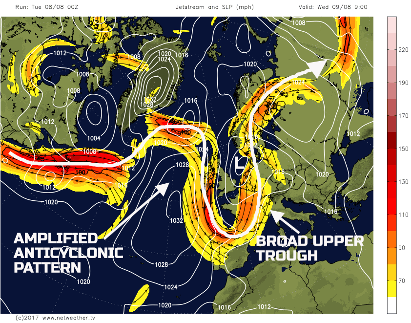
Wed 9th Aug: Overnight and into Tuesday and the UK will be beneath a broad upper trough and within its base quite a complex cyclonic development. This cyclonic development will manifest itself as an area of low pressure located just to the E of the British Isles. Frontal zones associated with the surface low pressure, along with some elements of convective activity, will maintain a risk of some significant precipitation across parts of SE England through the day. More on that shortly. The pattern upstream, to the W of the British Isles, will, however, be far more amplified, albeit embedded in a general mobile flow. This ridge and more amplified pattern will be approaching the UK, from the W, through the day. As a result, a distinct E and W split in conditions will develop across the British Isles through the day as a cyclonic N or NE’ly flow persists across E and SE areas of England, while a more anticyclonic N’ly flow arrives across many N and W areas.
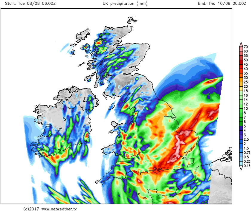
Through the course of Wednesday marked forcing, along with some convective elements will maintain a risk of showers or longer spells of rain across parts of the Midlands, E Anglia and SE England in particular. When the rainfall of Tuesday and Wednesday are combined, then some locally large rainfall totals are to be expected. Some localised flooding is possible, with perhaps more than 60mm in some instance within a 24 to 36 hour period.
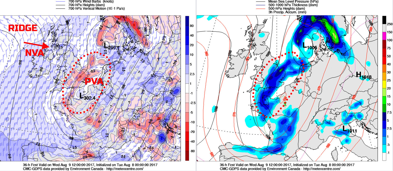
In complete contrast though will be much of Scotland and Ireland initially, where a chilly start is possible but with some sunshine. These predominantly anticyclonic conditions will then move down into N England and Wales through the course of Wednesday afternoon. As a result, many N and W areas of the UK will have a decent period of weather, especially compared with of late, with bright or sunny spells and variable cloud. The wet weather across SE England will, eventually, clear away towards the end of the day and then many areas will have clear spells and unusually chilly night on Wednesday for the time of year. The 00Z GEM model highlights this evolution well, noting a marked region of PVA across SE England, while NVA, in association with the ridged pattern, arrives across many N and W areas.
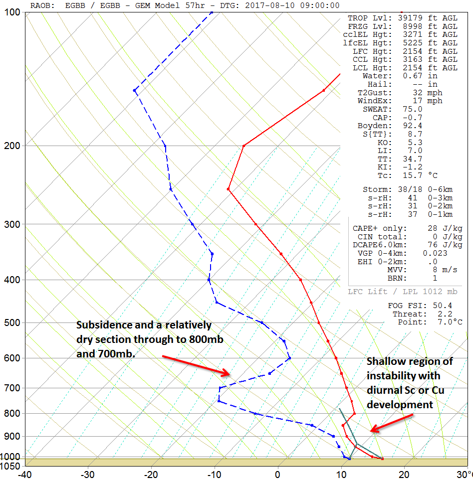
Thu 10th Aug: On into Thursday and, finally, after some considerable time much of the British Isles will be beneath anticyclonic conditions as the ridge topples down across the country. It will be, for early August a chilly start rurally, especially across Scotland and N England. Through much of Thursday, high pressure will maintain fine and settled conditions. Some small scale convergence zones may develop through the day, perhaps W Wales for example, which may lead to a few isolated light showers. However, for many areas of the British Isles anticyclonic conditions prevail with a dry day and with bright or sunny spells in a well-subsided atmosphere. The forecast sounding, for midday, for Birmingham highlights the anticyclonic, subsided profile well.
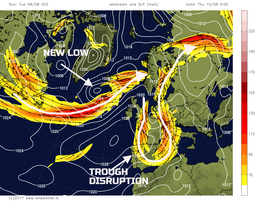
It is worth highlighting, however, that the overall pattern across the N Atlantic, despite the transient ridge, will be progressive. Some trough disruption is forecast to take place to the E and SE of the UK through the day, but at the same time a more zonal, potentially diffluent trough pattern will be allowing for cyclogenesis to take place to the NW. As a result, this will be a precursor to more unsettled conditions through into Friday, especially across more N and W areas of the British Isles.
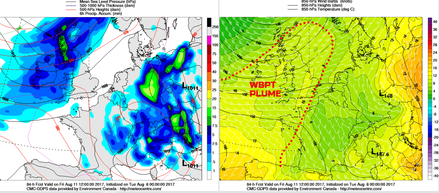
Fri 11th Aug: The working week is forecast to end, with a good model agreement between the 00Z ECMWF, GFS, GEM and the UKMO for the new developing low to then pass to the N of Scotland through Friday. This low pressure brings a return to more cyclonic conditions across much of the UK, along with some WAA as well, so a warmer and more humid day for most, especially across England and Wales. The frontal zones associated with the surface low pressure, at the moment at least, look to lose contact with the primary forcing and vorticity. However, quite a pronounced WBPT plume is forecast, then some marked orographic enhancement is predicted, with W hills of Scotland, England and Ireland perhaps experiencing the largest rainfall totals through the day.
The 00Z GEM model is a useful guide at the moment, but it is worth highlighting there are some uncertainties still over how quickly the associated frontal zones will progress SE through the day. Many S and especially SE areas of England may well escape with another predominantly dry day on Friday, with the rain not arriving here until evening. However, for many N and W areas then it will be an overcast, and damp day, some extensive low cloud and hill fog is possible within the WBPT plume as well, while a noticeable W or SW’ly wind develops in the N.
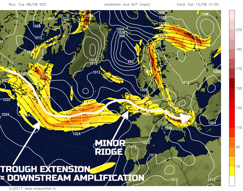
Sat 12th and Sun 13th Aug: So, we move into the coming weekend and with any residual frontal zone activity finally clearing away to the SE of England first thing on Saturday. Following on behind will be a Pm air mass, but this will come under the influence of an increasingly anticyclonic environment through the day. A minor ridge within the overall flow across the N Atlantic will lead to a mainly dry Pm NW’ly air mass, rather than a convective one. Apparently, some showers can’t be ruled out, but given that the flow will be more anticyclonic than cyclonic, then, overall, Saturday will be mainly dry for many with some bright or sunny spells and variable amounts of cloud.
The 00Z GFS highlights the minor ridge approaching from the W and, equally, of importance is the development of a trough-extension within the far W Atlantic, just E of Newfoundland which will aid to amplify the pattern once again, downstream, into the UK.
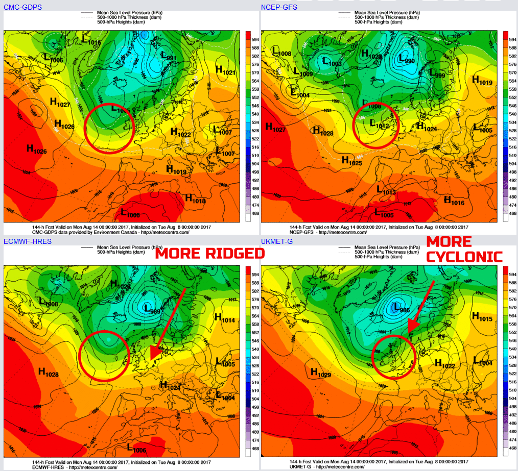
As a result by the time we get into Sunday, and there is some model agreement for a transient ridge to be moving E across many areas of the British Isles. However, as has been the case for many weeks the overall flow across the N Atlantic does remain progressive. As a result, just like is the case on Thursday, the ridge continues to move E away to the E of the UK to end the weekend. At the same time, cyclonic developments then take place to the W, in association with the trough extension, leading to another frontal system approaching. The 00Z UKMO, GEM, GFS and ECMWF are in reasonable agreement for this development. There is, however, some degree of divergence of how much of a ridged pattern will take place ahead of this evolution. The 00Z UKMO, for example, is far quicker to bring in more cyclonic conditions by the end of the weekend, then compared with the ECMWF which has a more pronounced ridge still in place by 14th 0000Z
Overall, both Saturday and Sunday don’t look like being too bad, as a result. Yes, it certainly won’t be a warm and summery weekend that many are now looking for, but equally, many areas should be dry for much of the weekend with some sunshine. However, by the end of it, wet weather may well be spreading into western regions, notably Ireland, but perhaps W Scotland, W England and Wales too by late Sunday onwards.
Medium and Longer Term 14th Aug onwards:
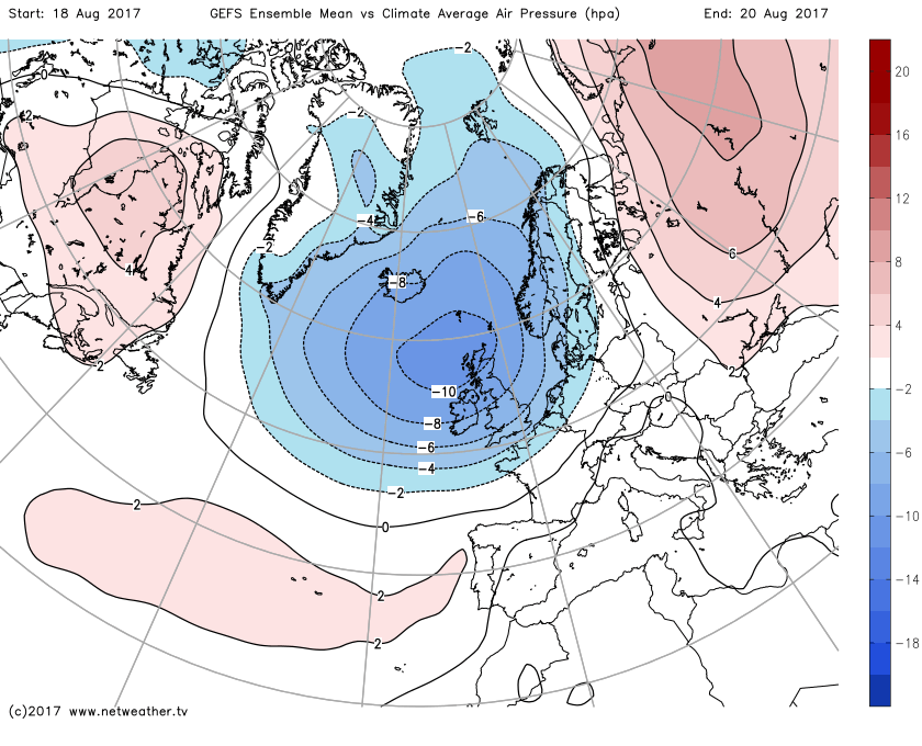
Looking further ahead, into the beginning of next week and there is low-confidence in the details. However, a rather changeable few day’s are possible into next week. However, and unfortunately, the overriding feature of the medium and longer term guidance, particularly the GEFS, EC EPS and the EC Monthly is for a potentially very cyclonic period around and just after mid-month, as exampled by the GEFS ENS Mean v Climate Average Air Pressure between the 18th and the 20th. It highlights a particularly pronounced signal for yet more low pressure and unsettled conditions. The outlook, for those hoping for some sustained summer weather, is, as a result, not good. We’ll perhaps have more on the longer term in an extended Synoptic Guidance later in the week.


.png?w=1200)


