With High pressure heading over the UK this weekend, there will be a lot of fine, settled but chilly weather around. However, the high pressure almost rolls over the UK rather than stopping in place. Early on Saturday there will be a northerly flow with showers for Lincolnshire and East Anglia. Clusters of showers will lurk close to the far southeast later on Saturday, over Kent and through the Strait of Dover and by Sunday morning there could be heavier bursts for Suffolk, Essex, around the Thames estuary and for Kent. Other parts of eastern England could also see some showers off the North Sea in the cool N/NE breeze.
Overall this weekend there will be a lot of sunny and calm weather but it isn’t a completely dry picture for the whole of the UK.
We have seen rain from cold fronts sweeping southeastwards recently but these bands soon pass by over Wales and England, where many areas remain in drought. In southern England, reservoir stocks continue to decline, there is ongoing pressure on rivers and groundwater with a continuing rainfall deficit. A dry weekend won't help. The Guardian reported
“Businesses could be barred from non-essential water use amid supply threat - Golf clubs, private schools and car washes may face tighter rules from water companies as England’s drought continues” 14th October.
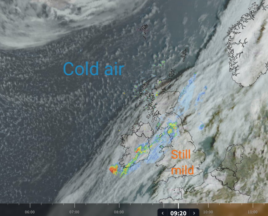
Netweather Radar (and satellite) showing the cold front rain on Thursday
We have one such cold front working its way down the UK today and through Friday morning, bringing rain. It links to an incredible low pressure, a storm which hit Iceland on Wednesday, and was analysed at 12Z on the UK Met Office chart (below) at 931hPa. Iceland may have measured a new October minimum pressure record as we await confirmed observations. Behind this cold front, we will be in a northerly flow later on Friday ahead of the High pressure.
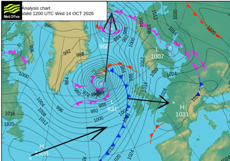
ASXX Weds 12z showing movement arrows by Friday 12z. The low centre away to the Arctic, slow moving cold front clearing English Channel and incoming High pressure from the Atlantic.
Friday night will be dry, clear and cold. There will still be the odd shower along the North Sea coasts of England, and for Pembrokeshire into north Devon with more cloud and a bit of a stirring breeze. Inland temperatures will fall with a frost on the grass, some pockets of mist and fog and an air frost in places.
Saturday
A cold but sunny start for most. There are those showers for eastern England with a cold breeze from the north. Daytime temperatures will be 12C for the Central Belt in Scotland and for Belfast. 13 or 14C for the Midlands in England and 14 for Bristol, Manchester and Cardiff. London and Hampshire could see 16C but the breeze will make it feel colder, especially along the North Sea coasts.
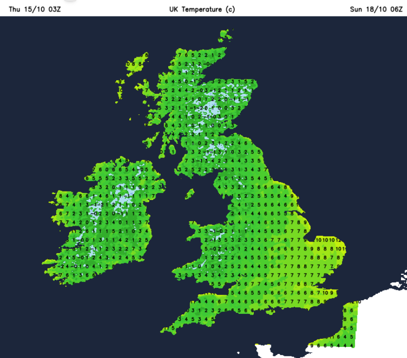
The breeze off the North Sea will save temperatures from falling too far in East Anglia and Kent. Elsewhere it will be another chilly and calm night with a frost in places.
Sunday
There will be a fine start on Sunday with more sunshine away from the showers in the southeast and from the North Sea. A few may reach further inland over Britain during Sunday but there will be plenty of fine weather around. A new frontal band will be approaching the Western Isles for the end of the weekend. This will throw high cloud ahead of it and eventually rain, but that might be after dark. The S/SW winds will also freshen during the day over the Islands.
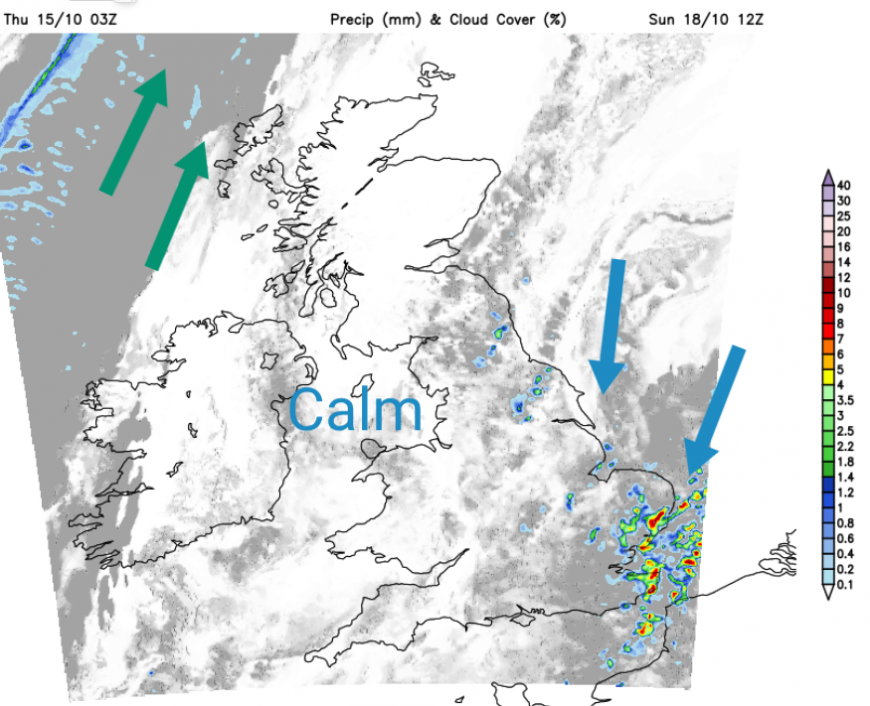
The high pressure will be heading over Scandinavia, resulting in a northeast then easterly steering flow for the showery cluster that will lurk close to East Anglia and Kent all weekend. So it could move towards the Humber and North Yorkshire Moors on Sunday night.
At the weekend, if you are caught in these showers, with more cloudy skies and this breeze off the sea it will feel cold and damp. Where it is dry and sunny, perhaps frost it will also be chilly but one of those glorious autumn days for appreciating autumn leaves and woolly knits.
Loading recent activity...