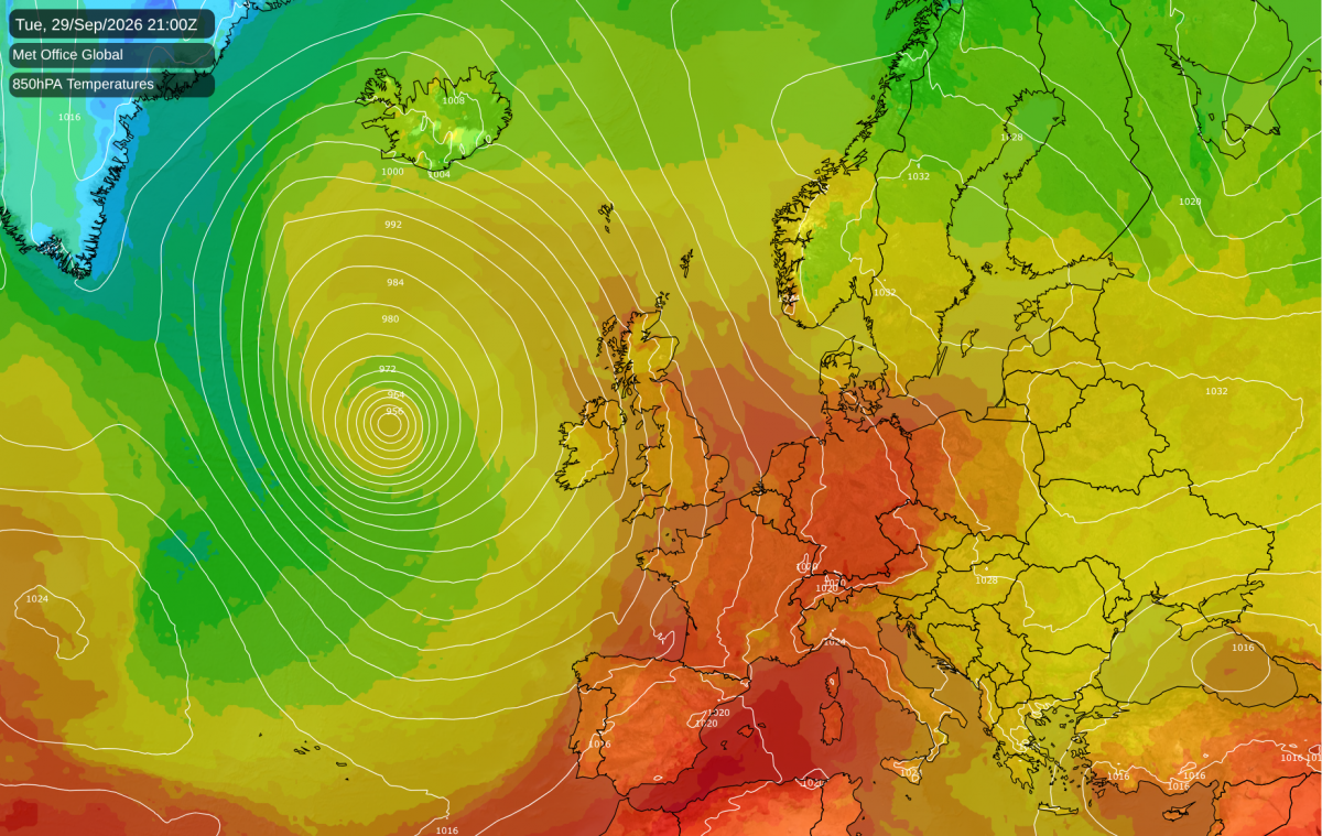
This September is set to be what I often think of as "an inconspicuously warm month", with temperatures about 2C above the long-term seasonal average on most days. It results in the monthly mean being exceptionally high, even though individual days don't seem particularly warm. In addition, most of the warmest days relative to the seasonal norm are being concentrated towards the end of the month - which, as temperatures typically cool as the month of September progresses, means that we avoid getting highs in excess of 30C at any point during the month.
It is looking increasingly probable that we will get a very deep depression tracking to the west of Britain around 29 September, bringing some very warm air for late September into Britain on its eastern flank. It looks probable that it will be quite cloudy and windy for most of the country, and so daytime maximum temperatures are forecast to peak at around 25C in southern England. But the night time minima look set to be more exceptional - some places may get no lower than 17 or 18C on the night of 29/30 September.
There is also potential for some thundery activity to develop ahead of a frontal system approaching from the west, particularly up the eastern side of England. There may also be some thundery activity embedded in the frontal system, most likely in western Britain. Such late season thundery activity is fairly unusual but not unheard of: October 2022 had several days with widespread thundery activity over much of England and Wales, also mainly associated with southerly winds. It is relatively common for south-western Britain to see thundery activity in early to mid-autumn: 2006 was a particularly stark example of a September and October which had frequent thunder in parts of the south-west.
Overall, September 2026 is looking set to be a top 5 warmest September over large areas of the country, and possibly locally the warmest.
The Central England Temperature series shows starkly that the rate of warming of the British climate is currently faster than it was when I was growing up in the 1990s. For January to September 2026, temperatures have been running about 1.8C above the most recent 30-year average ending in "0" (1991-2020). January was slightly colder than average, but every other month has been considerably warmer than average. During the 2020s so far, only 2021 has come out close to the 1991-2020 average, and every other year has been warm.
When I was growing up in the 1990s, the standard comparison point was the 1961-1990 average. Although the 1990s was regarded as a remarkably warm decade at the time, no years came in more than 1.1C above the 1961-1990 average. 1990 was running about 2C above from January-May, but although early August brought record temperatures, June and September 1990 were on the cool side and brought the anomaly for January-September down. One year - 1996 - was cooler than the 1961-1990 average, while 1991 and 1993 were both very close to the average.
We will need to get a substantially cold October, November or December for the Central England Temperature anomaly for 2026 to drop close to 1.1C above the 1991-2020 average. With the record El Nino event in the Pacific, where strong El Nino events are typically associated with mild and wet weather in November and December, this is looking unlikely.
As in many recent years, the Arctic sea ice extent was running at near record lows until July, but the melt rate slowed during August and early September, and the September minimum extent came in around 10th lowest for the period 1979-2026. Temperatures have been near or rather below normal near the North Pole during the past fortnight, which has helped to prevent further substantial melting.
In general, the September minimum sea ice extent in the Arctic declined substantially between around 1990 and 2012, but the trend has flatlined since the early 2010s. The Arctic sea ice extent for 2012 was above that of many recent years until July, but it set a record low due to remarkably rapid melting during August 2012, which has not been repeated in recent Augusts. However, the decline in Arctic sea ice extent up to 2012 was faster than was generally projected by climate models, and the recent stall in the reducing trend has served to bring it more into line with model projections.
Loading recent activity...