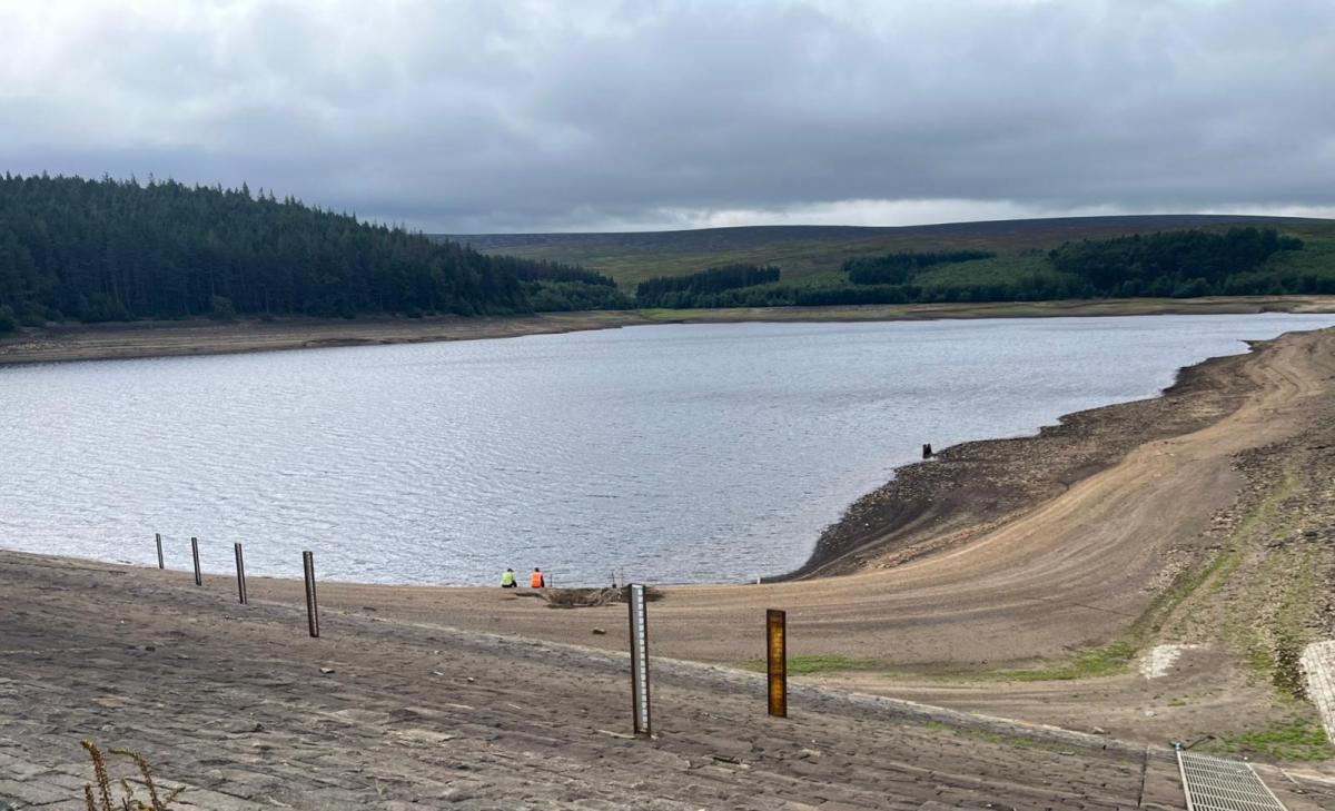
Droughts and significant water scarcity continue across Britain with autumn rain and showers mostly reaching northwestern parts of the UK. The weekend starts off unsettled with showers in the north but high pressure builds our way next week which means more dry weather. What might happen in the coming months is being researched and discussed to try to protect our precious water supplies.
There has been a meeting this week of water companies in England, the Environment Agency and Government officials to update the National Drought Group on winter plans. What can be done to prevent England remaining in drought until next spring. Above average rainfall would be needed to end the drought by April 2027 as water efficiency measures continue.
“Public water supply was the focus of the latest National Drought Group meeting with water company chief executives, called to give updates on their leakage reduction plus autumn and winter preparedness.” Gov.UK
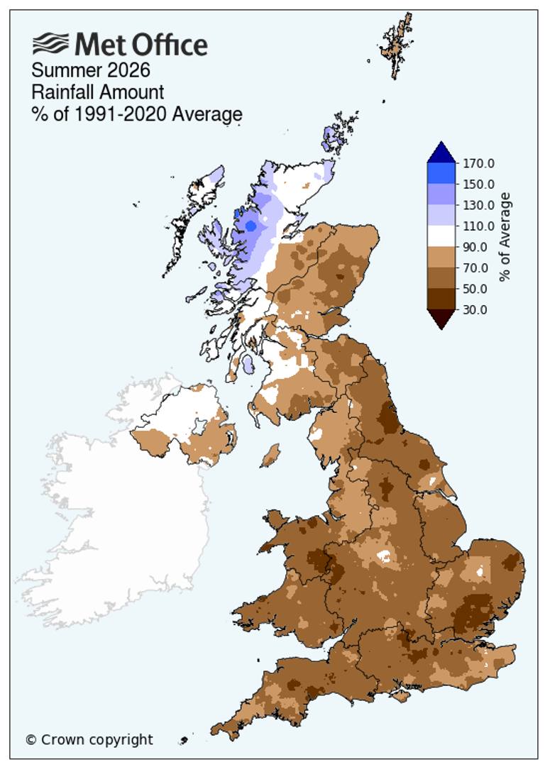
Almost three-quarters of England remains in drought after an exceptionally dry (and hot) spring and summer. Drought is only over when rivers, groundwaters and reservoirs are back to normal levels and it is going to take a lot of rain over many months to come out of drought.
“The National Drought Group, which includes the government, Met Office, regulators, water companies, farmers, Canal & River Trust, anglers, and conservation experts, is now meeting weekly to monitor the situation and coordinate action as part of the heightened incident response.”
The Environment Agency presented data looking at potential rainfall scenarios over the coming seven months.
1.MOST LIKELY SCENARIO SEPT TO MARCH: (Based on the Met Office three-month outlook and seasonal indications)
There remains a geographical divide with the north moving to recovery, followed by the Midlands and then finally parts of the south. By February, most places are back to normal. The East and West Midlands plus Thames Valley are in recovery with Devon & Cornwall and East Anglia remaining in drought, a traditionally dry time of year. Not great to start with water deficits. The outlook for wetter weather in autumn is set to bring some relief to most drought-hit areas. However, even in the most likely weather scenario, Devon & Cornwall and East Anglia are expected to still be in drought by the start of April 2027.
2.AVERAGE RAINFALL SEPT TO MARCH: (100% of average rainfall)
There would be a patchy recovery beginning next month, … Most areas would stay in drought for the rest of this year but January could see everywhere except East Anglia in either recovery or back to normal.
3.DRY SEPT TO MARCH: (80% of average rainfall) (Around a one-in-four likelihood of occurrence)
A fragile recovery could begin in November, with all four northern areas…By January, they would be back to normal status. Drought conditions would remain across the Midlands and the south for the rest of 2026… East Anglia, Lincolnshire & Northamptonshire, Thames Valley, Devon & Cornwall, Wessex (covering Dorset, Somerset, Wiltshire, and south Gloucestershire) Solent & the South Downs and the West Midlands would still be in drought by the start of April 2027.
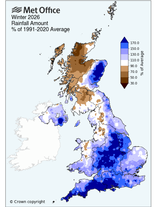
“For context, between September 2025 and March 2026, England received 130% of its typical rainfall, leading to recovery from last year’s drought.” This helped England through the dry spring of 2026; however, the summer was astonishing and has resulted in a very difficult harvest for farmers, with impacts on fish stocks, bird populations, and wider ecosystems.
Wales
14 September Natural Resources Wales “Wales remains in drought- while rainfall in recent weeks has slowed the worsening of impacts, we have not had enough as yet to change our drought status. In Wales, the July-August two-month period combined received 41% of expected rainfall. The Welsh summer was the hottest on record."
As of 8th September, Wales had seen 32% of September’s rainfall so far. Some river levels had returned to normal flows for the time of year after recent rainfall; however, many rivers have seen very little impact from rainfall, and remain exceptionally low for the time of year. Some groundwater sites remain exceptionally low for the time of year. Groundwater reserves take longer to recharge following even sustained rainfall.
Across the UK, there is a risk that the ‘drought conditions could increase the risk of localised flash flooding when significant rainfall returns. Hard, dry ground can lead to rapid run-off during intense storms and rainfall, leading to localised surface water and small watercourse flooding.’
These sudden deluges aren’t always that helpful. Flood water is very difficult to store for public water supply because it arrives so quickly and often just ends up flowing to the sea. Also, as it runs off the land, it can be high in sediment and nitrates.
Scotland
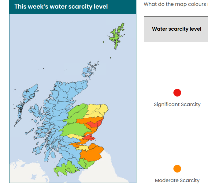
In Scotland, eastern areas have had months of dry weather, and although there have been showers in autumn, the region still has significant concerns with impacts for abstractors. Currently, there isn’t the huge demand for residential or industrial water in Scotland as there is in the southeast of England, for example. Droughts are identified when the water reserves and forecast rain don't balance with the current usage and expected demand. However, these water scarcity reports from the Scottish Environmental Protection Agency show a stressed picture that needs to be considered for future planning and policy.
“Four areas remain at Significant Scarcity, and further four areas are now approaching the same level, meaning up to eight areas could soon be at Significant Scarcity. While recent showers brought some temporary improvement, river flows, groundwater and soil conditions across much of eastern Scotland remain under pressure. Sustained and widespread rainfall will be needed for lasting recovery”. SEPA
This weekend
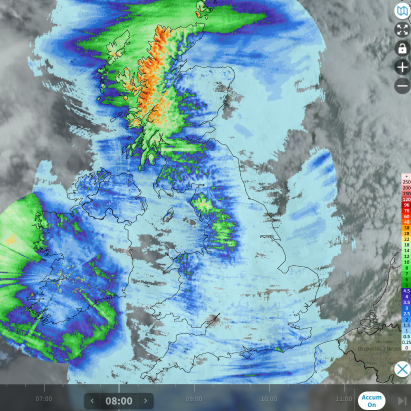
24 hours rainfall accumulations until Friday 18th 8am from Netweather Radar
At the moment, the UK is stuck in an overall westerly flow where frontal bands are arriving from the Atlantic with low centres closer to Iceland. These bands of rain are making their way south and east across Britain but tend to fade and break up once they reach southern Britain. Heavy showers are wrapped up around these lows, but again they are mainly piling into northwest Scotland, with just a scattering moving over other parts of the UK.
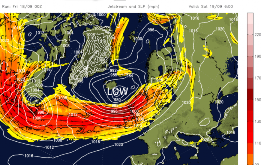
We have seen a strengthening jetstream as the high latitudes lose daylight and the air in the north becomes colder. This is a common theme in autumn as the temperature contrast builds with warmer air still over mainland Europe and the mid-Atlantic.
We have frontal bands sweeping across Ireland and then Britain on Friday with blustery winds and outbreaks of rain. Gwynedd, Cumbria into the Pennines, western Scotland and Northern Ireland will all see rain, but elsewhere it will be light and patchy at most. There will be warmer air mixed up with this system.
The low pressure to the north of Scotland means it will be a windy day on Saturday. The fresh to strong westerly winds will bring a host of heavy showers across Scotland with sunny spells in between. Elsewhere, it will be a blustery day but drier and brighter for most. Around the Bristol Channel there will be more cloud and damp weather extending over Devon (particularly the north) and Somerset where winds will be lighter. It will feel warm for southern Britain with temperatures into the low 20sC.
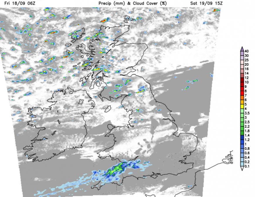
This line of rain will extend towards London later on Saturday but it's never much and the band will fade into the night. It will turn cool overnight for northern Britain.
Sunday sees the showers in the far north easing away as pressure builds over SW Britain. It will remain blustery for northern and eastern Britain until the afternoon but southwestern areas will have light winds and fine weather. Overall, it will be a better day with more sunshine but still a lack of rain for those areas that need it.
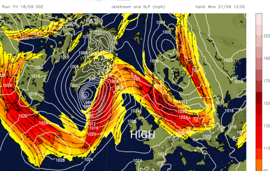
Although frontal bands will graze Northern Ireland and the northwestern half of Scotland, there will be a lot of dry weather next week with high pressure close by.
El Nino
And there is the supersized El Niño to add to the picture. For the UK, it could bring a greater risk of wet and stormy weather this autumn. But again, would that be low pressures battering NW UK, or managing to bring rain to eastern England?
Previous El Niño winters have been associated with a greater chance of wet and windy conditions in late autumn and early winter, and colder, calmer conditions later in the season. This is not dealing with certainties; it is looking at historical patterns.
“The latest Met Office seasonal September to November outlook points towards the increased likelihood of a warmer and wetter than average autumn, with the signal for unsettled, wet and windy weather becoming stronger later in the season. This means there is a greater chance of periods of heavy rain and strong winds during October and November than we would typically expect at this time of year.” Head of Environment and Energy at the Met Office, Sarah Davies.
Environment Agency Chief Executive Philip Duffy “The drought situation remains very serious, and we cannot underestimate the challenge ahead over the coming months.”
“Water supplies are limited, and we continue to balance the needs of agriculture, public water supply and our environment. A few weeks of rain cannot reverse the deficit we face from the very dry spring and summer. We still need everyone else to use a little less water to speed up the drought recovery."
Saving water and valuing this precious resource has to become part of our everyday lives.
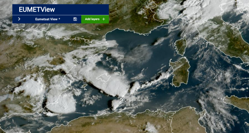
As our climate changes, these extremes continue: lengthy dry spells and heatwaves, periods of heavy rain leading to flash flooding all leading to impacts on people, businesses, communities and the environment.
This week there has been torrential rain and devastating flooding in eastern Spain, as a British man died when his car was swept away in floodwaters in Olivella, west of Barcelona. Flash flooding submerged and closed roads as flights were disrupted. Amber warnings for heavy rain and thunderstorms remain on Friday for the Balearic Islands, including Ibiza and Mallorca and yellow warnings for SE mainland Spain, including the Costas. Conditions are set to improve slowly through the weekend.
National Drought Group and Actions by the Government
Loading recent activity...