September has been a changeable westerly month over north-western Europe so far, but still generally warmer than average, thanks to exceptionally high sea surface temperatures following a record breaking hot summer. There has been a prolonged hot spell over Spain and Portugal which has extended to France at times, but Britain has seen only limited imports of hot weather due to the strength of the prevailing westerlies. Last Sunday, when a marked hot plume pushed eastwards through a large part of Europe, the Met Office confirmed a high of 28.6C at Northolt. But the southerly flow was too short-lived to give Britain much chance of seeing temperatures of 35C and above for the fifth consecutive month.
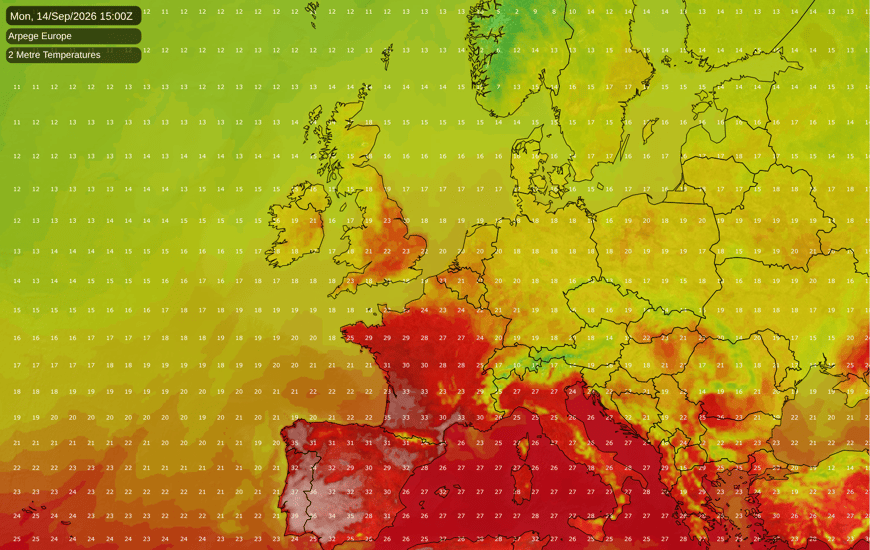
The heatwave is set to continue in Spain and extend to Portugal for another three days, with temperatures forecast to exceed 40C in some places, especially in inland parts of southern Portugal and in south-western Spain. Temperatures in south-western France may reach around 36-37C in some places. However, much cooler air will spread from the north-west into these regions around next Wednesday. Temperatures over western and south-western Europe then look set to be far less remarkable, though still generally above the long-term seasonal average due at least partly to the high surrounding sea surface temperatures.
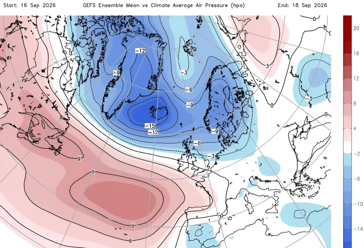
The outlook for Britain for the rest of September is for a continuation of the changeable west to south-westerly type, but with a strong signal for high pressure to build to the south during the last third of September, which may ridge into the southern half of Britain at times. Currently the medium range forecast models disagree as to how far north this high pressure will extend, but a north-south split looks probable with drier and more settled weather developing over southern Britain and continued wet weather for much of Northern Ireland and northern and western Scotland.
This build of high pressure has potential to bring about a resumption of unseasonably warm weather in Spain and Portugal, extending into France at times, as highest pressure looks set to become centred over central and western parts of Europe, potentially drawing up some hot southerlies from north Africa. Due to the uncertainty regarding how far north the high pressure will push, it is not clear how much of this hot weather will reach the British Isles, but there is certainly potential for some unusually high temperatures for late September to arise towards the end of the month, particularly in the south.
A number of Septembers during the early stages of major El Nino events have had spells of predominantly dry sunny weather for much of Britain, including those of 1997 and 2015. September 2015 was also notably cool by recent standards, with a high frequency of northerly winds, while September 1997 saw warm days partially offset by cool nights for much of the country. September 2026 is set to end up rather warmer and more unsettled overall.
With a record breaking El Nino event developing in the Pacific Ocean, global temperatures have now become inflated to the point where they are setting new monthly records again. According to Copernicus, which bases their results on the ERA5 reanalysis, August 2026 was the warmest August on record globally. In terms of the absolute temperature, it was the joint warmest month on record globally along with July 2023. Sea surface temperatures have become particularly exceptional overall, boosted strongly by the developing El Nino event, while land surface temperatures have been less remarkable, but still record warm.
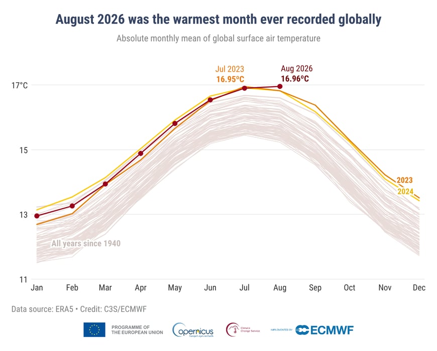
According to Climate Reanalyzer, temperatures have remained record warm globally into early September, with the sea surface temperatures across Earth continuing to be particularly remarkable. It may well be "touch and go" as to whether September 2026 ends up the warmest September on record globally, as September 2023 was particularly warm globally during the second half of the month. I expect that with El Nino continuing to develop, we will probably see a record warm October, November and December globally.
Meanwhile, Britain's remarkable warmth from February through to August, and a relatively warm first third of September, has meant that in the Central England Temperature series from 1659, temperatures for the rest of 2026 need to average 0.2C below the old 1961-1990 average for 2026 to avoid being the warmest year on record. Given that 1961-1990 averages are close to 1C below the 1991-2020 averages, and that the El Nino conditions favour mild and wet weather in November and December, it looks highly unlikely that the rest of the year will be anywhere near cool enough to prevent the record from being broken. Persistently high sea surface temperatures off western Europe have potential to accentuate mild and wet weather over Britain as we head through late autumn and into early winter. During the 20th century, the mean annual Central England Temperature averaged around 9.5C, but 2026 could well breach 11.5C for the first time.
Generally 2026 has so far been much warmer relative to normal over England and Wales than over Scotland and Northern Ireland, so a record warm year in 2026 is looking less certain for Scotland and Northern Ireland. But over both England and Wales, another record warm year looks extremely likely.
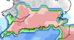
2 hours ago, Iceaxecrampon said: You mean runs like this….. Aye at least it'll stop them crying about the M4 🙄
The ECM 18hrs run is still underwhelming and wildly different from the GFS and UKMO at T144hrs. The troughing to the nw looks pretty angry so just a matter of time before that topples the high . It is however colder at day 6 than its earlier run...
Light to moderate rain again now.
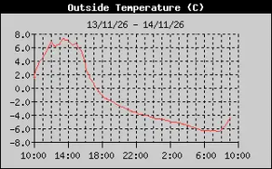
Was a few days ago, apologies for late report but it was Friday night into Saturday morning. Today's Low Temp -6.4°C at 7:29 Friday night into Saturday morning for clarity. We have had a few sub-zero temperatures in November but they only reached...
TWO's third and final winter 2026/27 update before their official seasonal forecast at the end of the month. https://www.theweatheroutlook.com/weather-news/8027/winter-2026-27-outlook
Had plenty of rain here this evening.