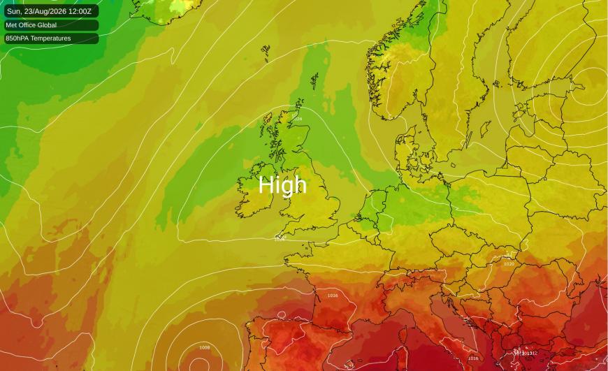
Summer 2026 is looking highly likely to surpass 2025 as the hottest summer on record for much of the UK, especially England and Wales, which have especially been affected by repeated heatwaves. However, while high pressure will dominate the weather this weekend and during Monday as well, it will not be particularly hot, as we currently have an Arctic air mass occupying the British Isles, which moved in yesterday. Instead of it being hot and sunny, we can expect broken cloud cover, some sunny spells, and temperatures close to the long-term seasonal average.
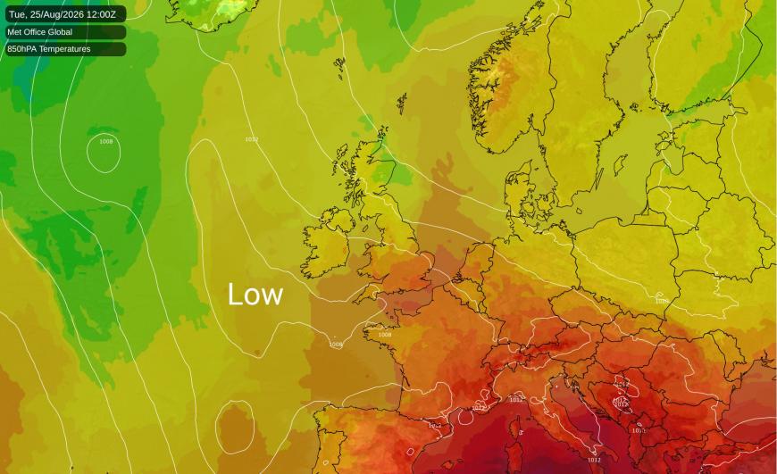
Low pressure looks set to take over from Tuesday/Wednesday next week and last through to the end of August, which is set to ensure that August will be nowhere near as dry as July was in the southern half of Britain. However, rainfall for August as a whole still looks likely to come out below normal for many regions, due to a very dry first half of the month.
With some warmer air coming in from the south-east, it looks probable that as the low pressure takes hold, temperatures will mostly be above the long-term seasonal average, with potential for the mid to high 20s Celsius to be reached widely across England between Tuesday and Thursday. This won't be on a par with the heatwaves that we saw during late May and on and off during the summer, but it will further increase the chances of this summer ending up as the new record warmest summer.
Also, the Central England Temperature series (roughly representing the English Midlands) has seen such sustained warmth from 1 January to 20 August that temperatures only need to be 0.16C above the old 1961-1990 average for 2026 to end up as another record warm year. As the climate has warmed by roughly 1C since 1961-1990, this looks highly probable. The likelihood is further increased by the upcoming El Nino, as historically strong El Nino events have been linked with Britain seeing mild, wet and windy weather in November and December.
Normally there is a lag between El Nino conditions developing in the Pacific Ocean and rising global temperatures - typically a strong El Nino event temporarily adds 0.2-0.3C to the global mean temperature, which is superimposed on the long-term warming trend and results in record highs. 2023 was an unusual case in that the global temperatures rose to record highs just as the El Nino was developing. The 2026/27 has begun in a more normal way from this point of view, with global temperatures having not yet reached record highs up to July.
According to Climate Reanalyzer, which uses the ERA5 reanalysis, global sea surface temperatures have risen to record highs since June, but the temperatures over land masses have lagged behind, which is typical with oncoming El Nino events. The land temperatures have so far prevented the overall global temperature from setting record highs. But provisionally the global mean temperature - including land masses as well as over the oceans - has reached record highs towards mid-August. Thus, I reckon that we can expect to see a succession of record warm months globally starting in August or maybe September.
The El Nino is forecast to be the strongest for over a century, which has potential to result in a particularly warm year globally in 2027.
As in many recent years, according to the National Snow and Ice Data Center (NSIDC), the Arctic sea ice extent was running at close to record lows during June and July, but during August, the melt rate has dropped well below what we saw during 2012, the year of the record low minimum. Thus, a record low Arctic sea ice minimum extent in September is looking increasingly unlikely, although it will still be well below the 1981-2010 average.
.png?w=870)
The Antarctic sea ice extent has swung the other way. During June and July, it was below average but not close to record lows, but in early August there was a pause in the seasonal increase in Antarctic sea ice extent. As a result, it is now running at close to record lows, although currently still higher than the record low levels in August 2023.
Loading recent activity...