It’s been a hot week and a hot Friday. Temperatures have again risen above 30C with the hot weather adding to other issues on the railways today. There will be a warm night in store for much of the UK but a cooler prospect for one side of the country this weekend.
Wisley in Surrey reached 35.5C on Thursday, the highest temperature in England this week so far. As cloud bubbles up this afternoon it might be interfering a little with the rise in temperatures, just blocking some of that heating sunshine around the observation enclosures. On Thursday, Scotland reached a high of 29.3C in Charterhall. 31.3C for Cardiff Bute Park in Wales and Northern Ireland reached 27.5C in Killowen, Co. Down.
The record for the most 34C days in a year has been broken, with the eighth day of 2026. This beats the previous record of seven days in 1976 and 2020.
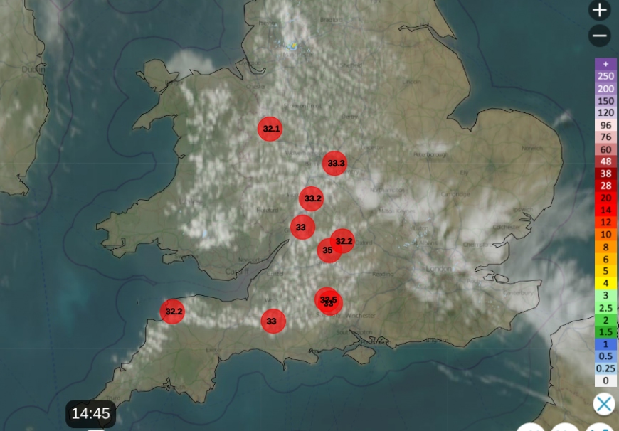
Netweather Radar with top ten temperatures before 3pm
There has been a little bit more cloud around today, over parts of England and the high ground of Wales with a weather front, a cold front over northwest Scotland. This is bringing rain to the NW Highlands and Orkney with temperatures around 13 or 14C. Imagine that if you are suffering in the heatwave at 33C
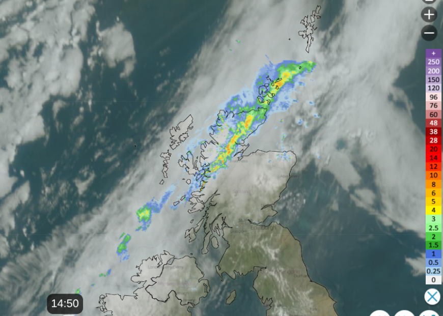
Frontal cloud and rain showing on the Netweather Radar on Friday afternoon
There is instability in the medium levels giving the lovely Altocumulus Floccus clouds in the top photo. The front in the far north will be around at the weekend with more cloud and outbreaks of rain for northern and eastern Scotland on Saturday with an important wind shift. The only other front to watch out for will be a warm front on Monday from France heading towards SW Britain. Temperatures over the weekend could ease a touch but hotter air could return from the south early next week.
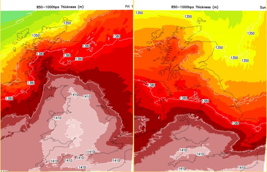
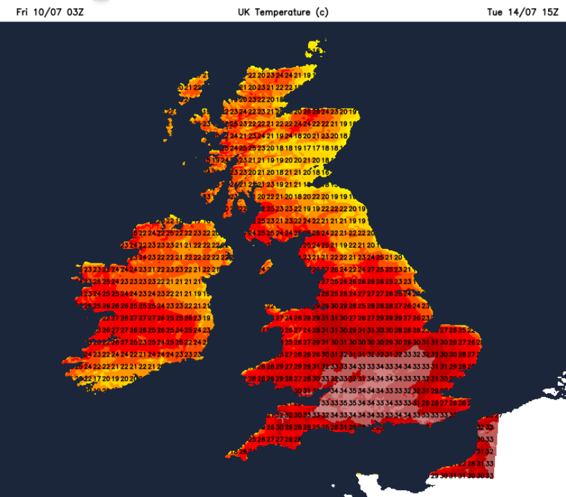
Very warm air over the UK on Friday 10th but easing from northeast Britain by Sunday 12th
A northeast to easterly breeze off the North Sea will lower the temperatures for eastern Britain at the weekend but it will remain particularly hot for SW Britain.
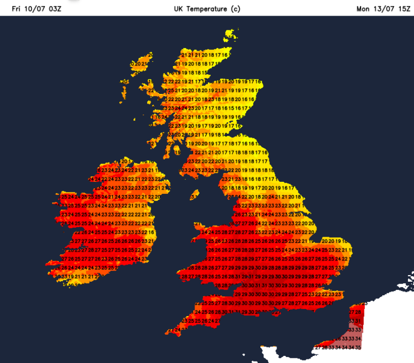
There is a gradual easing of the temperatures into Monday but they look to them rise again for the middle of next week. They could move up into the mid 30sC once more. There is some uncertainty linked to the frontal zone in the southwest and how any showers or even thunderstorms develop for the start of the new working week.
It’s a fair way off but there is a signal on the forecast models for next weekend to be cooler and fresher. And that is a long way off if you don’t like the heat.
Water companies are asking us to really think about our water usage and “Love every drop”. The risk of fire spread is increasing as shown on the map for England and Wales. Fire & Rescue teams are also reminding the public to take care and think if out in the countryside, no naked flames, campfires or discarded cigarettes.
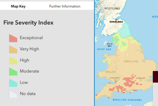
England and Wales CROW Access Fire Severity Index Maps - Sunday 12th
This heatwave although not yet as extreme in terms of peak temperatures and humidity is becoming notable for its longevity. And as this is Heatwave3 there are these cumulative impacts of drying, electricity use, water consumption and fire risk.
Copernicus: Record heatwave brings hottest June for western Europe during second-warmest June globally
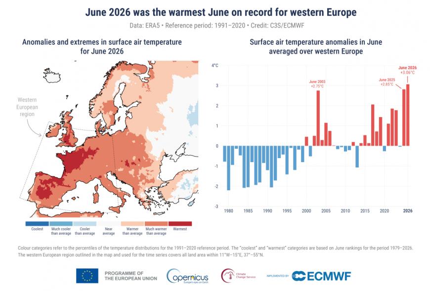
Above (Left) Map showing anomalies and extremes in surface air temperature for June 2026. Colour categories refer to the percentiles of the temperature distributions for the 1991–2020 reference period. The extreme (“coolest” and “warmest”) categories are based on June rankings for the period 1979–2026. (Right) Bar chart showing monthly surface air temperature anomalies in June averaged over western Europe (11°W–15°E, 37°–55°N). Anomalies are relative to the June average for the 1991-2020 period. Data source: ERA5. Credit: C3S/ECMWF.
“The succession of heatwaves illustrates the growing challenge posed by increasingly frequent and intense heat extremes across Europe and the globe” as our climate warms.
There was also widespread dryness combined with the extreme heat which contributed to wildfire activity. Drought conditions have also begun to develop, even though Iberia had a very wet winter.
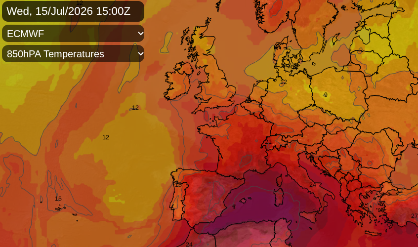
More heat over Europe by the middle of next week
“June 2026 underscored how profoundly the climate is changing. Western Europe recorded its warmest June on record, and continued record warmth in the global ocean. Together, these records reflect a climate system continuing to accumulate heat. The result is increasingly intense heatwaves, a persistently warm ocean, and growing risks for people, ecosystems and infrastructure across Europe and beyond.”
Samantha Burgess, Strategic Lead for Climate at ECMWF
Loading recent activity...