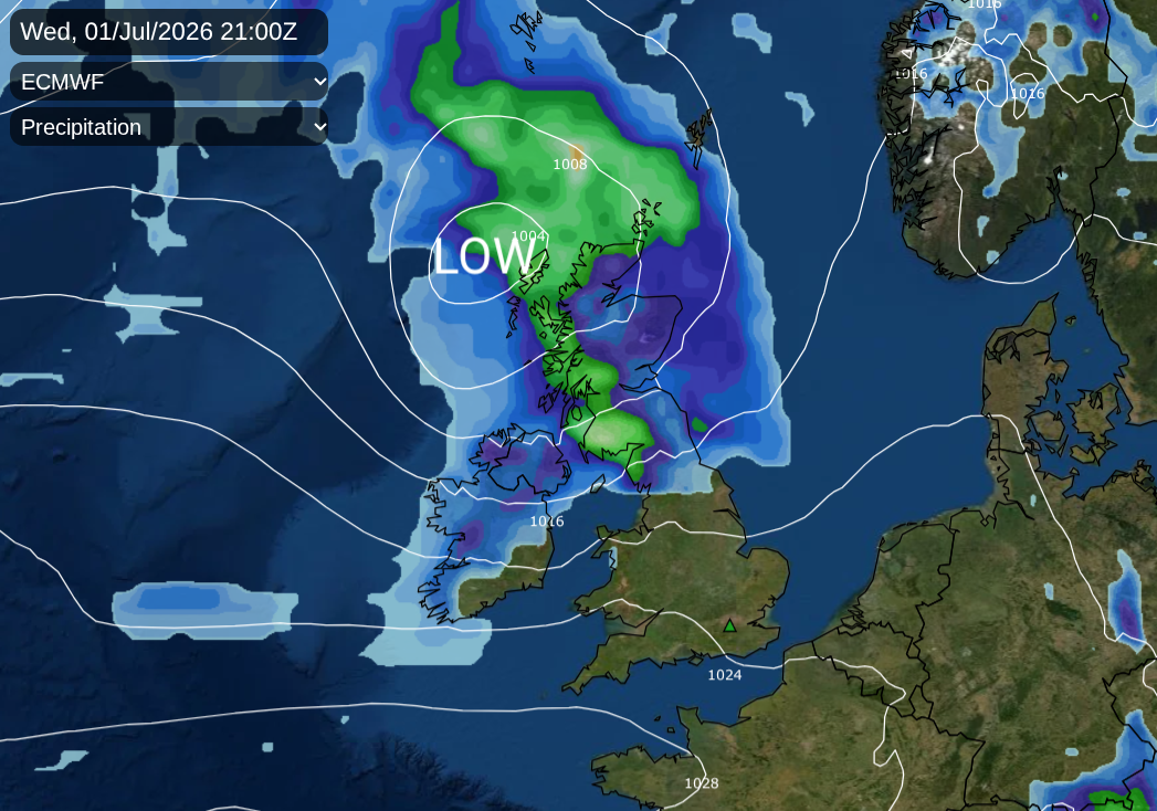
This week will be warming up, potentially hotter by the middle of next week. The grass pollen is very high at the moment. There is also nettle pollen in the air, so you may be extra sneezy or have itchy eyes as we experience a peak in the grass pollen season. There will be a spell of wet and windy weather during Wednesday night, which will sound lively for northern parts of the UK
Dry weather continues this week, for southern Britain for the start of July. The National Drought Group met a few weeks ago, on June 18th, before Heatwave2 of 2026. Maybe we do need to name these heatwaves as well as our storms?
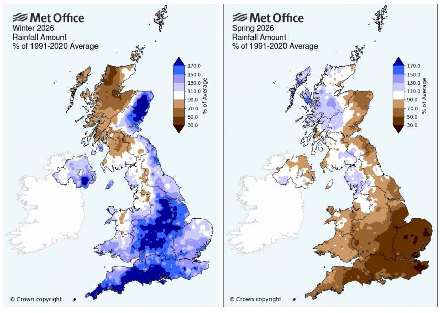
Met Office Head of Environment & Energy Sarah Davies said: “The weather in recent months highlights the variability we can experience, with a notably dry spring followed by a much wetter start to June, and more settled, drier conditions returning more recently.”
SE Water introduced a Temporary Use Ban TUB for customers in their Kent region during the last heatwave, a hosepipe ban, with other areas also seeing some restrictions.
The National Farmers Union highlighted how irrigation is vital for the growth of many crops. Our national food security depends on farm businesses functioning in a profitable way by “having reliable access to the water needed to produce food for the nation.”
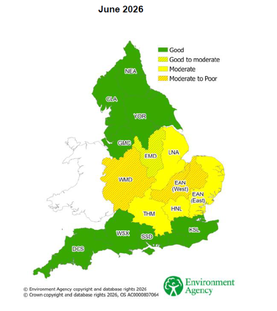
Conditions are projected to be Moderate to Poor for abstractors in parts of East Anglia and West Midlands after the dry spring. The irrigation prospects reflect the water situation using current river flows, groundwater conditions, the latest available weather forecasts and Met Office seasonal outlooks.
National Drought Group chair and Director of Water at the Environment Agency, Helen Wakeham, “While many of us enjoy the hot weather, we ask everyone to be mindful of their water use. Every drop saved leaves more available for farmers, our local rivers and wildlife.”
This week will be warming up, not yet back to the high heat and humidity of late June but reaching the high 20sC, possibly passing 30C by the weekend. Next week could be hotter. Heatwaves cause significant peaks in water demand, which can lead to public supply outages, so another potential hot spell will be watched carefully.
Western and northwest Scotland will see a fair amount of rain over the next few days as a series of low pressures rattle in from the Atlantic. High pressure is building in from the southwest, and this will allow the dry weather over much of England and Wales to continue. The first week at Wimbledon couldn’t be better. No need for the roof. Luckily the Atlanta stadium in Georgia does have a roof and air-conditioning as England play DR Congo at midday (5pm BST) today. Atlanta is under a Heat advisory with temperatures in the 90s Fahrenheit (the mid to high 30sC), feeling more like 105F.
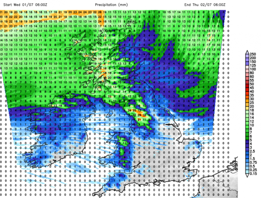
There will be a wet and windy spell of weather in the north later today and overnight. The frontal rain will arrive for the north coast of Northern Ireland on Wednesday afternoon and set in for western Scotland. This rain will spread across more of Scotland, with heavy rain overnight for the Cumbrian Fells, western Pennines, Yorkshire Dales, even reaching Eryri National Park (Snowdonia). There will be some rain for northeast Britain, but still a rain shadow effect. Eastern and NE Scotland now have water scarcity alerts, with East Lothian standing out at Moderate scarcity.
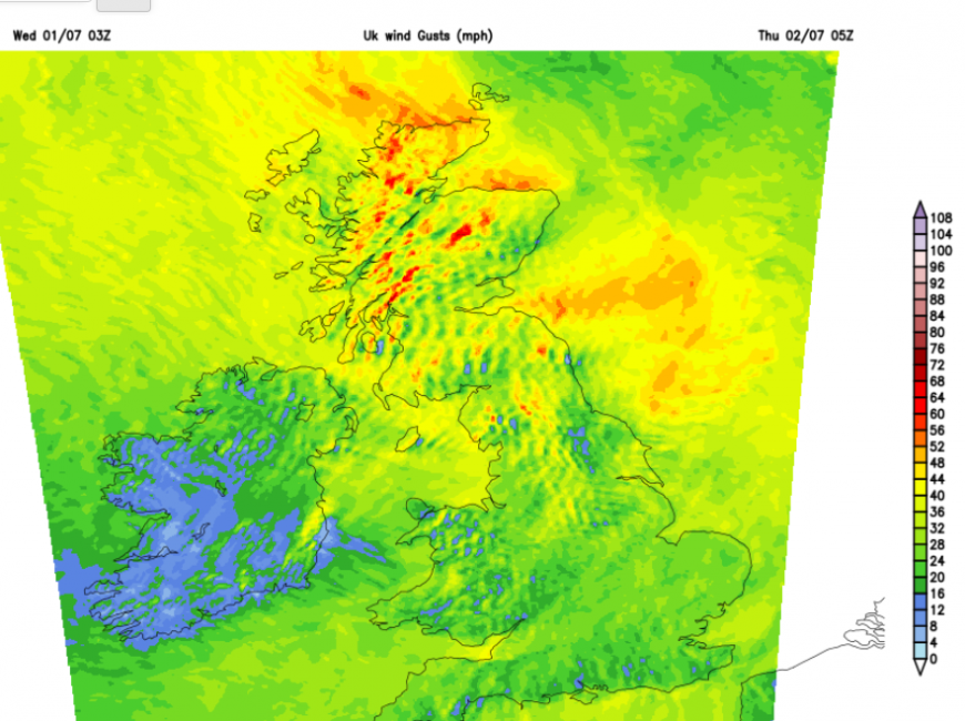
As the main frontal rain clears away over the North Sea, gusty winds will wrap around the Low centre and bring showery rain to western Scotland. For exposed coasts and hills in Scotland, there could be gales tonight. The trailing weather front will move southeastwards over the rest of Wales and England during the small hours.
Thursday morning could see more cloud and a few showery outbreaks of rain over southern counties of England and London from that trailing weather front. It’s not much rain, just a change. Northern and western parts of the UK will have a fresher feeling day on Thursday, but the southeast will warm up again. The strong gusty winds will move away from the Northern Isles later on Thursday.
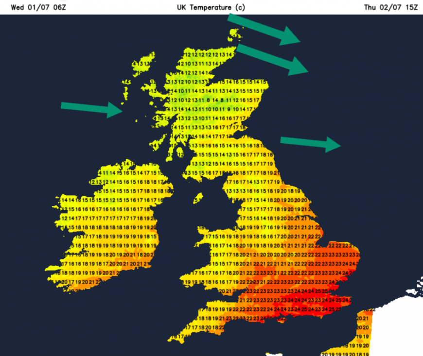
Northern Britain will have a cool Thursday night but very warm air will surge up from the southwest on Friday. Belfast up to 21C, Bristol and Birmingham around 25C and London around 28C. This is not the same as the heatwave of last week, but is an increase on the low 20sC that we have seen this week. A new warm front will bring rain into western Scotland with more cloud ahead of it. To the south of this, it will be warm and sunny.
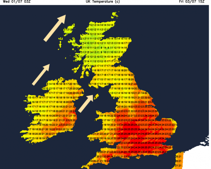
Further pulses of rain will arrive from the Atlantic along the trailing weather fronts. There will be more cloud over northern Britain and Northern Ireland with showery outbreaks of rain from the west. Further south, the high pressure will be doing its job, keeping things dry and settled, although western Wales could also see more cloud and a bit of rain on Saturday. It could be a breezy day with a moderate westerly wind.
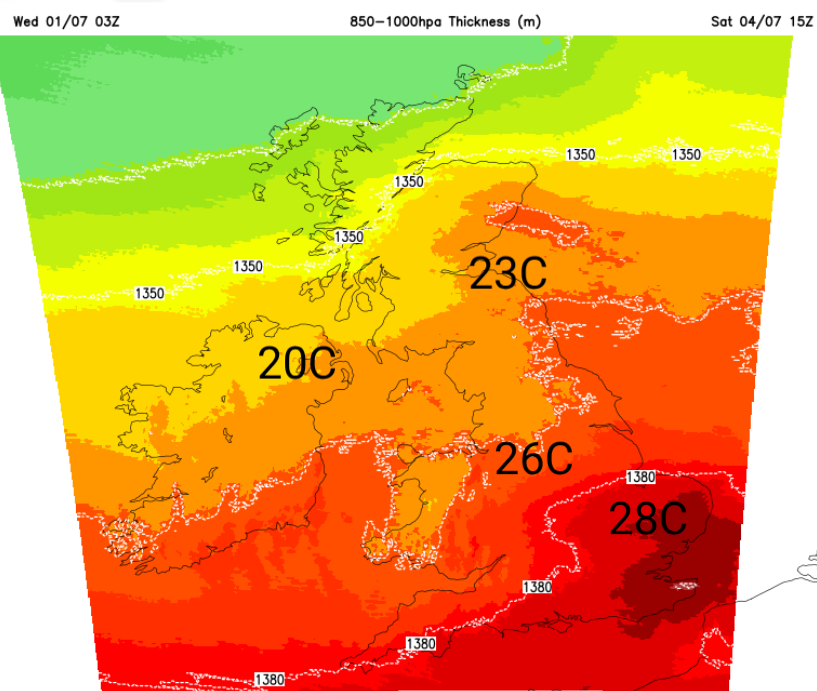
Aberdeen and Newcastle could see 23C and for East Anglia, London and the Home Counties, temperatures will be in the high 20sC, perhaps reaching 30/31C in a few spots.
It looks cool in the far north overnight with more rain and cloud on Sunday. More of England will be feeling very warm with temperatures in the high 20sC with lighter winds with lots of sunshine for Wales too. There looks to be a surge of heat up through the UK by the middle of next week, so we will see how that develops.
Loading recent activity...