Two weeks after an unprecedented heatwave for May, Europe is being hit by another early heatwave, with temperatures forecast to reach 40°C in southern Spain and even western France on Sunday and Monday. The hot air pushing north across Spain is expected to spread north and east over much of Europe over the coming few days and will reach as far as southern Scandinavia and the Balkans by early next week, with southern, central and eastern areas of England also seeing some of this hot air arrive from tomorrow.
Intense heatwave will grip large parts of Europe and southern UK over the next 6-7 days at least
It’s turned hot and humid today under clear skies across southern, central and eastern areas of England, Southend-on-Sea in Essex has reached 31C, several stations in London and East Anglia reaching 30C, despite brisk southwesterly wind.
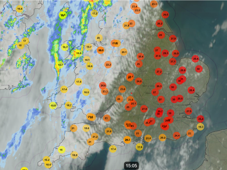
Not as hot on Saturday with more of an easterly breeze off the North Sea, which will bring a cloudy start in the east. But the heat is back on Sunday and through much of next week across southern, central and eastern areas of the UK, with models now agreeing on the heat intensifying, as high pressure over mainland Europe builds further north, allowing temperatures to rise further.
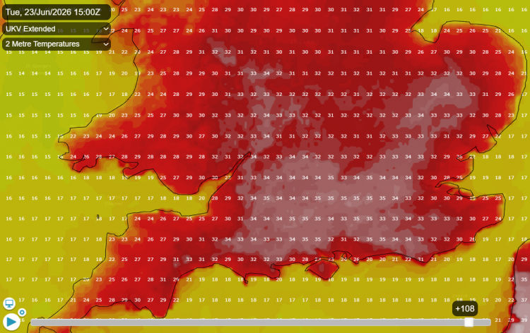
Some models are indicating temperatures reaching 35-36C on Monday and Tuesday across southern England, which will challenge the long-standing June maximum temperature record of 35.6C last set on 28th June 1976. But the heat looks to continue across large parts of England and Wales to the end of week, with temperatures reaching 30C everyday next week in parts of southern and southeastern England.
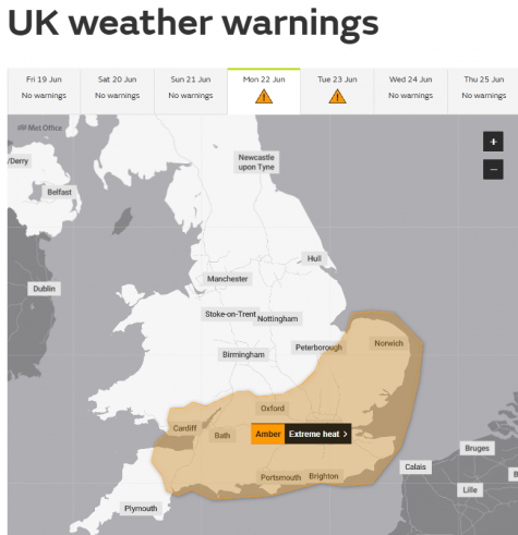
The Met Office have issued an Amber Extreme Heat Warning for large parts of southern England and Southeastern Wales for Monday and Tuesday for impacts to people and infrastructure, with water safety a particular concern. Heat Health Alerts have also been issued for parts of England, with Amber Alerts for SE England, London, East of England and Southwest England. There are also Yellow Alerts for the East Midlands and West Midlands.
A large upper-level ridge expanding north and northeast across western and central Europe from North Africa will persist for the next 7 days, eventually expanding north and west over the UK through next week. On the western edge of this strong high pressure system, a south to southwesterly flow will pull in very hot air from NW Africa, with temperatures on the rise through the weekend over Spain and France, where the mercury is expected to reach up to 40°C in some spots, but it will also be hot in southern England, the Benelux countries, Germany, Switzerland, northern Italy, and beyond.
In France, the national weather service Météo France has issued orange weather warnings for heat for Today onwards across large parts of the country, including Paris. They forecast widespread temperatures between 34°C and 38°C, with values approaching 40°C in several regions in the west and centre of the country over the weekend. Sunday and Monday perhaps among the hottest days ever recorded in June.
Across Iberia, more used to these extreme temperatures, but still exceptional for so early in the summer and well-above average, the Spanish weather service AEMET mentions several days from Sunday with temperatures reaching the mid-to-high 30s widely, locally 40C in the south, with 40-42 ºC in the Guadiana and Guadalquivir valleys of southern Spain, and the possibility of 44 ºC in localised spots on Tuesday.
There will be a risk of thunderstorms daily on the northern periphery of the heat dome. Like yesterday, heat and humidity but weaker heights and cooler air aloft across northern France, the Low Countries and northern Germany will create a highly unstable atmosphere during peak heating in the afternoon. Breeze convergence and a few upper disturbances moving northeast on the edge of heat dome will trigger afternoon thunderstorms over these areas, some of which could be severe.
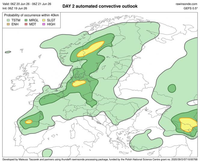
The UK will escape this risk of thunderstorms today and over the weekend, but on Monday we could see some thunderstorms break out across parts of Wales, central and southern England. Ingredients are there for severe thunderstorms across the south. ECMWF high resolution model, for example, has over 2000 j/kg CAPE over quite a wide area. However, there needs to be a trigger to break the cap caused by subsidence of air under strong upper level ridging, so relying on breeze convergence and high temps to pull the trigger. If it does go, strong deep layer shear is forecast thanks to strong westerly flow aloft and winds backed towards the surface - so potential for large hail, frequent lightning and intense rainfall (PWAT of 1.67 inches or 42mm).
Localised thunderstorms can’t be ruled out for the rest of the week, plus the odd shower here and there, but generally it’s looking a dry picture for most of the UK from this weekend, even the north that’s been cloudy and wet, once today’s rain across northern and western areas clears east. This is because the upper level ridge over mainland Europe will expand north across the UK while high pressure builds at the surface too.
Loading recent activity...