After a showery day today, with temperatures reaching 18-20C across the south this afternoon in any sunny spells, it will turn drier and temperatures will be on the rise through the rest of the week across all parts of UK, as high pressure builds north and a plume of warm air spreads up from Spain.
By Friday we could see temperatures reach 28C across eastern England and widely in the low to mid 20s elsewhere, with potential to reach 28C or higher over the Bank Holiday Weekend too, which would meet heatwave criteria. A heatwave is officially defined by the Met Office as a period of at least three days when the temperature stays above a certain threshold. In London, this threshold is 28C.
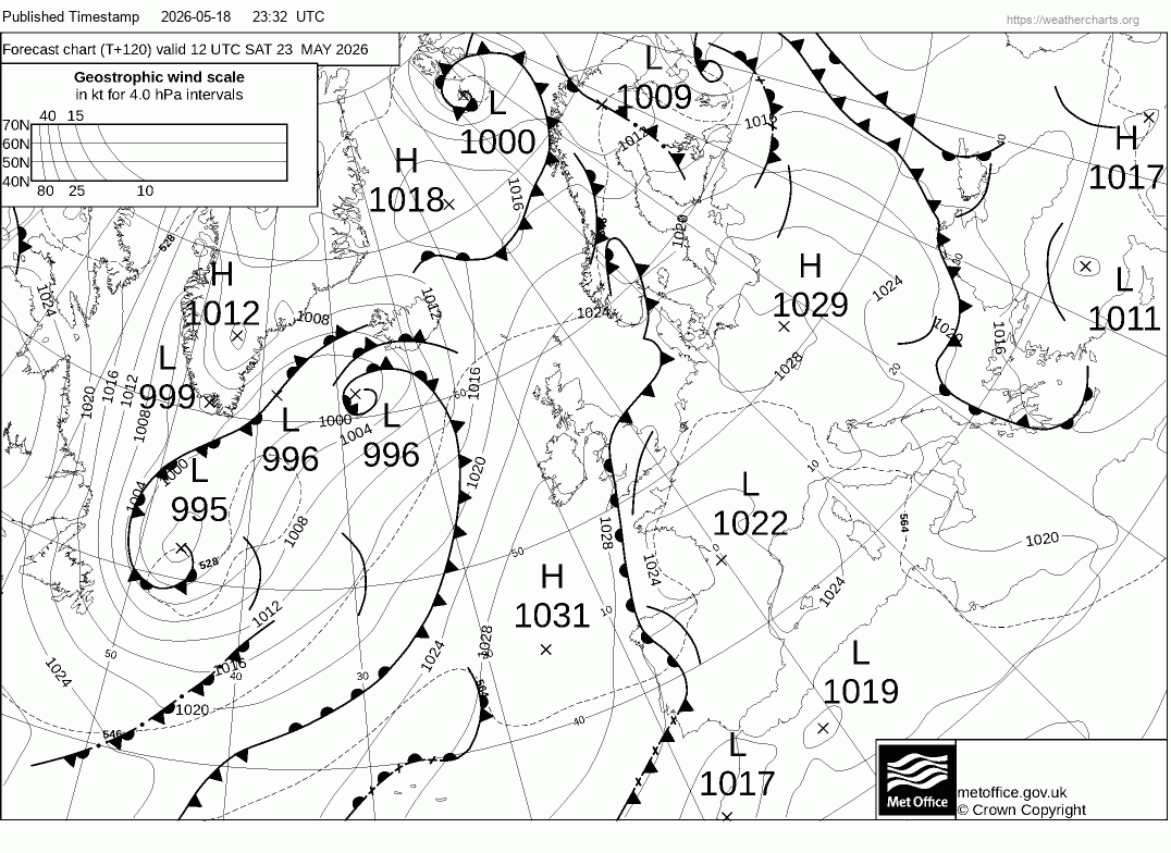
However, there are differences between the weather models over how warm it will be over the Bank Holiday Weekend, particularly on Saturday, due how the models handle an upper trough and surface cold front moving in from the west and whether it clears through on Saturday, clearing the very warm southerly plume and introducing cooler air from the west.
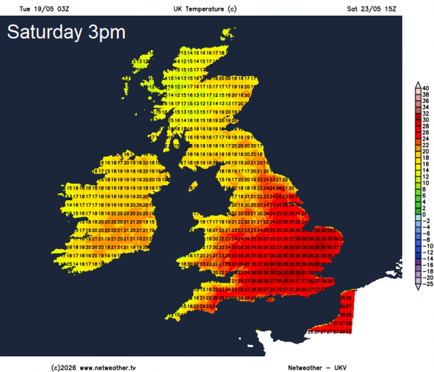
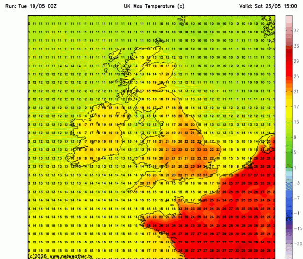
The model differences can be seen on their temperature projections for Saturday. 03z UKV shows temperatures reaching 31C in the afternoon across SE England and East Anglia, while 00z ECMWF shows 25C at best in SE England, 00z GFS shows temperature lower still in the low 20s at best in SE England.
UKV model shows 31C on Saturday
... but GFS not quite as warm
This is because both models bring an intact trough off the Atlantic eastwards across the UK, with a surface cold front parallel to the trough also moving east, introducing cooler air from the west, cloudier skies and also a risk of heavy showers and thunderstorms developing ahead or along the front.
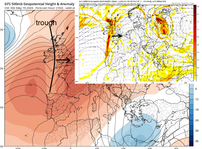
Previous runs of ECMWF and GFS slowed this upper trough to the west and disrupted it into a cut-off low. 00z ECWMF does disrupt the trough to the west still, but sends a shortwave trough east across central / northern UK, with a cold front, weak on its southern extent, clearing east on Saturday - introducing cooler air from the west for a time. 00z GFS brings a more intact trough east and then disrupts the trough further east over the continent, so is keenest on bringing in cooler Atlantic air on Saturday behind a surface cold front.
Potential for a few thunderstorms in the south on Saturday ahead of a cold front clearing east - which could introduce cooler air for a time, however, uncertainty on timing of any cold front clearing through, this will determine how hot it gets on Saturday
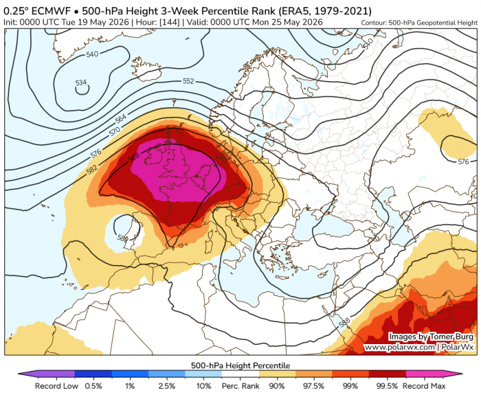
Still a few days off this being resolved. But whether the trough pushes through or not, all models indicate a rapid rise in pressure and heights from Sunday, with an unusually strong upper level blocking high developing over or near the UK. So strong are the forecasts that Percentile ranks of 500 hPa heights are close to record values for May. This strong blocking high driven by large scale subsidence of air deep through the atmosphere from near the top of the troposphere. This subsidence of air causing warming of the air at the surface, so we could see temperatures build rapidly again on Sunday and Bank Holiday Monday in dry and sunny conditions, perhaps into the high 20s celsius. UKMO shows 29C on Monday in southern England.
00z EC showing potentially record-breaking 500 hPa heights over the UK on Monday with blocking high deep through troposphere
So heatwave criteria could well be met if Saturday as well as Friday turns out hot in the end, with Sunday and Monday looking potentially hot across SE England.
Loading recent activity...