It’s been a cool start on Monday; chilly and even sub-zero for some where the skies have been clear overnight. There have been wintry showers over the hills and mountains of northern Scotland, giving occasional white patches, and a tricky mid-May frost to keep gardeners and growers on their toes. This week, temperatures will remain at or below average with a cool N/NW flow.

This cooler than average week wil bring more chilly nights and so a risk of frost. There looks to be a shift to something warmer next week. At this time of year, the sun is strong, and if you are in a sheltered, sunny spot, it can feel pleasantly warm with high UV, but in the shade or with a breeze, it feels noticeably cooler, especially in the evenings. When we have warmer air from the south, you don’t need to keep taking a jumper or coat on and off.
There is high pressure out west over the North Atlantic, which keeps the flow from the north or northwest over the next few days. This high will slip southwards towards the Azores later this week, which could interrupt the chilly flow. Around this high, there will be frontal bands from the northwest bringing rain to parts of Scotland and Northern Ireland, but they fade as they nudge over Britain. There will be showery outbreaks of rain, but no persistent heavy soaking episodes to help the dry ground. Wednesday does look particaualrly showery.
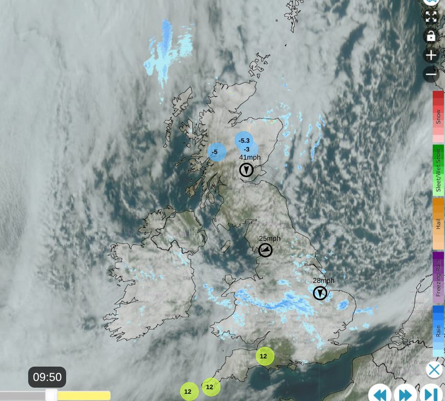
Netweather Radar and satellite imagery showing the cold front over southern Britain wth rain and cloud extending to Netherlands and over Ireland. Still sub-zero for the Scottish mountain tops and pinks of snow showers over the Grampians
The radar image from this morning shows the cold air over the Scottish mountain tops with snow showers heading for the Cairngorms. The band of cloud with outbreaks of rain stretching across Wales, the Midlands into East Anglia is a cold front moving southwards. Behind that there is more broken cloud with bright or sunny spells and a few showers for eastern Britain. The air is cold and there is a light northerly wind. To the south of the frontal band there has been some sunshine lifting the temperatures but the cloud will increase.
The band of cloud and showery rain will move over southern Britain during lunchtime and this afternoon with clusters of heavier showers for Hampshire and the Isle of Wight as damp weather trails back over Dorset and Somerset. Elsewhere, there will be a lot of fair, often bright weather. It just will feel cool.
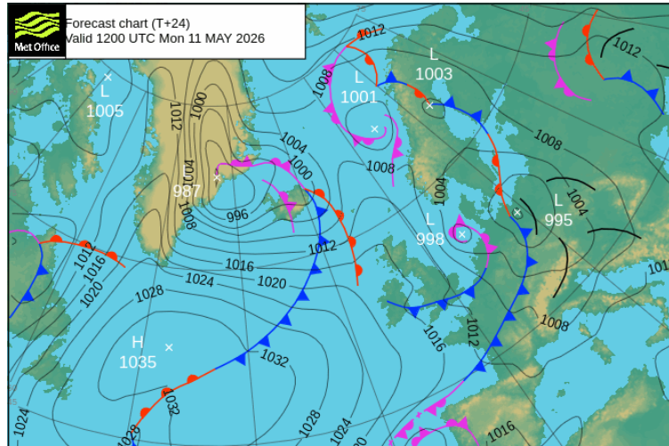
There is another weather system which will topple in from the northwest later today, bringing rain and cloud to the Scottish Islands and overnight to northern and western Scotland. Ahead of that there will be clear skies and again the risk of a touch of frost, for England and Wales but the frontal cloud will reach over northern Britain by dawn.
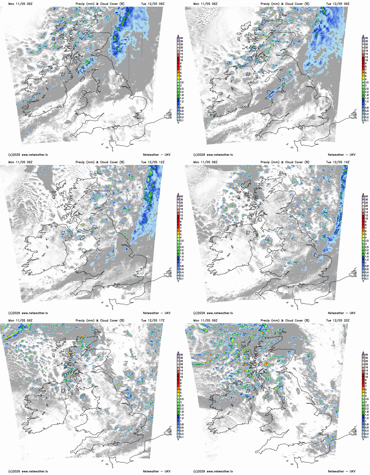
The frontal bands will bring more cloud down through the UK on Tuesday. The frontal rain will turn more showery in the daylight hours with a sunny, but chilly start for southern Britain. A host of rain showers will follow over Scotland on Tuesday morning with snow over the mountain tops. Northern Ireland will also see some showers in the morning, towards the northeast. The shower activity will become subdued by lunchtime across the UK as the frontal band swings away from The Wash. There will be plenty of frontal cloud lingering over southern Britain but fine, even sunny weather to the north. Temperatures will be 12 to 16C but it will feel cooler in the NW wind. The winds will be very light for London into Surrey.
By teatime on Tuesday there will still be a few showers running down the east coast of England, a scattering for Kent and SE England but a new rash heading into NW Scotland with a more wintry mix over the high ground.
A rash of showers will develop into Tuesday night for the NW quadrant of the UK, including some heavy downpours. Again there will be clear skies over the southern half of the UK but with a westerly flow, it won’t be as chilly. NE Britain will have light winds and the showers further west will reach across the country through the night.
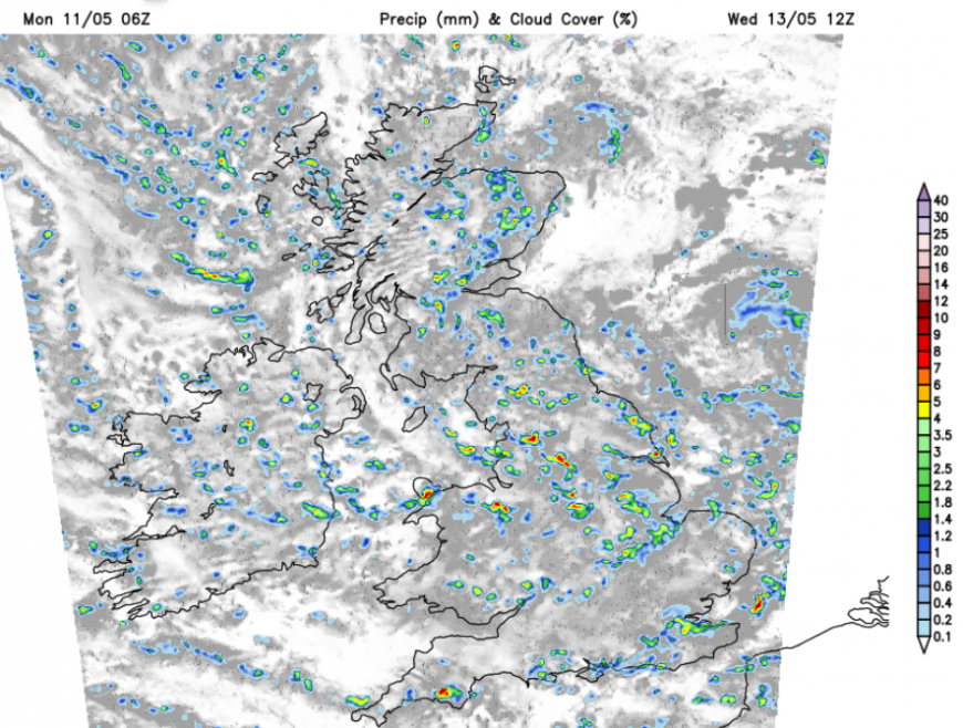
Rash of showers on the UKV model for Wednesday
By dawn on Wednesday a low pressure will be to the northeast of Britain, with bands and clusters of heavy showers swinging around this low across the UK. There will be bright spells in between but a much higher chance of seeing a downpour in the middle of the week. Northern Ireland, Wales and SW England will feel a cool NW wind on Wednesday. Wednesday night looks chilly for northern and eastern Britain.
Loading recent activity...