The weather is set to stay mostly fine and dry in the coming week as high pressure dominates, though there will be some exceptions. A few isolated showers are possible in the far north today, while Monday will see showery rain moving south across northern and eastern areas, perhaps turning thundery over eastern England. Thursday may see showers arrive across the southwest, which may then spread north across western and northern areas on Friday. Otherwise, it’s largely fine and dry with sunny spells after any early cloud clears.
High pressure generally in control through the coming new week, though its influence fades over the BH Weekend, with risk of more unsettled conditions taking over
It will be warm today and tomorrow across the south, temperatures reaching the low 20s degrees celsius, reaching the mid-teens in the north. However, as high pressure centred just to the west today drifts east to be centred over the North Sea towards mid-week, a brisk easterly wind will develop. This will bring maximum temperatures down into the low-to-mid teens towards the east, highest temperatures towards the west where they may reach the high teens with shelter from high ground - such as western Scotland and west Wales. Warming up again across the east later in the week, as winds turn southerly, with temperatures back in the high teens or low twenties.
Looking ahead to the Bank Holiday Weekend, still some uncertainty, but there continues to be a signal for more unsettled conditions to develop between high pressure to the west over the Atlantic and high pressure over eastern Europe. By no means a washout, but there could be showers or longer spells of rain for some during the long weekend.
For now, best of the sunshine today across southern, central and eastern England, though it will become hazier with patchy high cloud. More in the way of cloud across Scotland, northern England and Wales, thick enough to bring a few mainly light showers in the north and later in the west, but also some sunny spells possible too. Temperatures reaching 17-19C, perhaps 20C in the southeast. Cooler in the far north of Scotland.
Monday will see an upper level low drop south across northern and eastern areas, this will support thicker cloud and showers to develop across Scotland and northern England before spreading south across eastern England during the afternoon and early evening - where they may turn heavy and thundery. Western and southern areas generally dry, sunny and warm, showers arriving in the southeast later. Temperatures reaching 14-17C in the north, 18-21C in the south.
High pressure builds northeast across northern Britain on Tuesday, a cloudy start with some showery rain possible in the far south in the morning before clearing, otherwise a mostly fine and sunny day. But a brisk easterly wind across southern areas of Britain, gusty around coasts, making it cooler than of late in the east. Highest temperatures could be across central and western Scotland with lighter winds here.
Similar conditions on Wednesday, high pressure centred over the North Sea by then, but still a gusty easterly wind across the south, perhaps gusting to 40mph along coasts, calmer in the north, generally dry and sunny though. Highest temperatures in the west. Potential for a few showers to clip Cornwall later in the day.
Strong easterly wind developing in the south from Tuesday making it cooler in the south and east
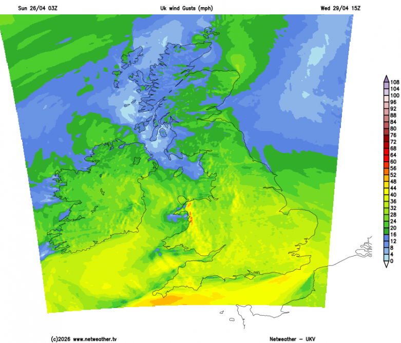
Largely dry and sunny on Thursday, though still a strong easterly wind in the south. An area of low pressure looks to drift north just to the southwest of Ireland later in the week, this could introduce some showers across the far southwest of England, southwest Wales and Ireland on Thursday, then perhaps a wider chance of scattered showers across western on Friday, but some uncertainty on this. Eastern areas of the UK staying largely dry and sunny on Friday and warmer too, with the easterly wind turning southeasterly or southerly by then.
Some uncertainty over detail for the Bank Holiday Weekend, but low pressure to the southwest may move northeast - bringing outbreaks of rain or showers across England and Wales at some point, drier and perhaps sunnier across Scotland - with high pressure holding on here.
Loading recent activity...