Wednesday saw the UK's warmest early April day in 80 years, with 26.6C reached at Kew Gardens in London. The warmth became confined to SE England yesterday, with Frittenden in Kent reaching 23.4C, but elsewhere westerly winds behind a cold front sweeping east brought cooler conditions with temperatures at or below normal. This sets the feel for today and through the weekend, with temperatures close or a little below normal. It will turn windy tonight and over the weekend, with rain clearing east tomorrow morning followed by the classic April showers, though with sunny spells in between.
Most of the UK is now in a cooler westerly flow Friday morning, eastern areas of Britain staying dry and bright today, but a deepening area of low pressure to the west of Ireland will introduce strengthening southerly winds, increasing cloud and rain across the west this afternoon, some heavy rain possible for N.Ireland, gales developing too across coast of western Ireland, N. Ireland and through the Irish Sea and adjacent coasts. Temperatures only reaching the low teens at best this afternoon, after we saw 20C or more in the southeast yesterday.
Turning windier and more unsettled into the weekend, as deep Atlantic low moves in slowly towards the north
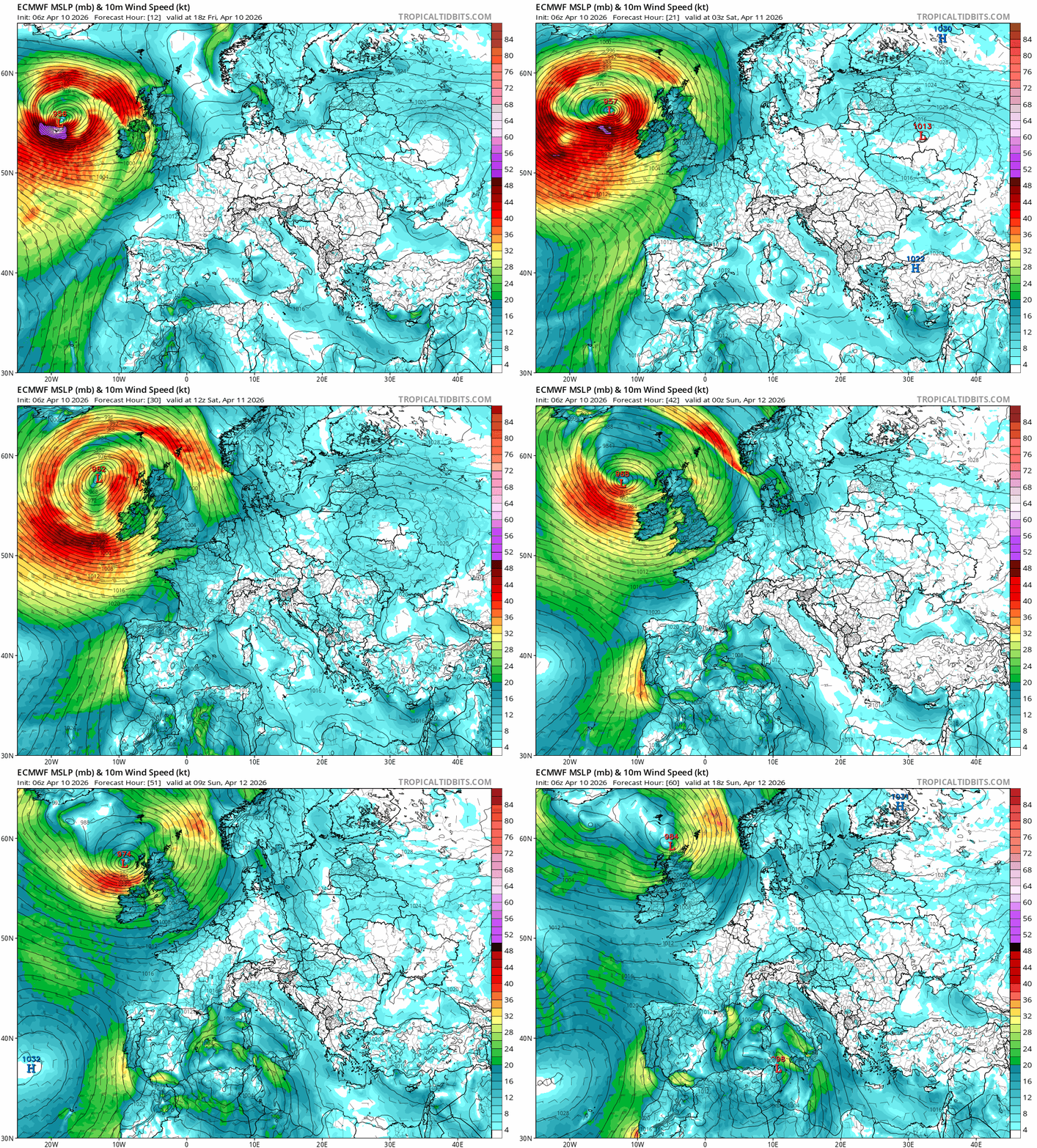
Windy with a band of rain moving in across the west overnight, gales across western coasts. Drier towards the east tonight, before the band of rain clears eastwards across mainland UK Saturday morning, followed by sunny spells and blustery showers, which will be mostly in the west and locally heavy and thundery with hail and wintry over mountains. Parts of eastern England may stay dry with the best of the sunshine. A windy Saturday, with coastal gales in the west. A cool day too, temperatures reaching 10-13C at best, but the wind making it feel colder.
Sunshine and showers the order of the weekend once band of rain clears Saturday morning

Sunday remains breezy or windy, with sunny spells and further showers, most of the showers across the west initially, but perhaps developing further east across central and eastern England - where they could turn heavy and perhaps thundery. Temperatures ranging from 11C in Edinburgh to 14C in London, about average for the time of year.
The weather looks to remain changeable next week, but steadily turning warmer. Sunshine and scattered showers around Monday, a drier and sunny Tuesday, rain at times for the north and west Tuesday night and Wednesday, a mixture of dry and bright or sunny spells and some showers around for the rest of the week. Does look fairly dry for southern and eastern England through the week, just the odd chance of catching a shower here while turning warm by the end of the week, perhaps reaching 20C.
Changeable next week ...
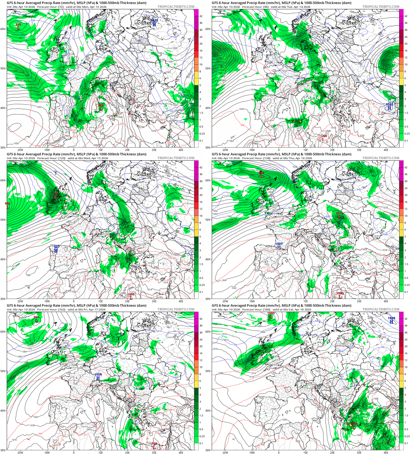
... but turning warmer in the south at least, especially later in the week

Winds will ease on Monday, as the isobars move further apart, mostly dry and sunny initially, but scattered showers look to develop - which could be locally heavy, slow-moving and perhaps thundery, sunny spells in between, parts of eastern England and the south coast may stay dry. Feeling a little warmer with lighter winds, temperatures reaching 11-15C.
A brief ridge of high pressure looks to build in for Tuesday, bringing a mostly dry and bright or sunny day for many, the exception will towards the far west, with strengthening breeze and rain spreading in across the island of Ireland and perhaps SW England and Wales in the afternoon. Temperatures ranging from 12C in Edinburgh to 16C in London, so a little warmer.
Cloudier with areas of rain spreading northeast at times across northern and western areas Tuesday night and through Wednesday, locally heavy towards the northwest, drier towards the southeast, but even here it may cloud over with some patchy mostly light showery rain for a time. Temperatures reaching 13C in the north to 17C in the south (with any sunshine).
Drier, sunnier and warmer Thursday and Friday southern areas, though a few showers can’t be ruled out. Most likely windier and more changeable in the north, with Atlantic fronts passing through bringing more in the way of cloud, lower temperatures and a chance of rain both days.
Loading recent activity...