




The Met Office has a yellow warning of snow for Tuesday morning. There has been a slight adjustment of the area covered by this warning, but it is worth understanding what the marked yellow area shows. This is not the limits of any snowfall, it could snow elsewhere and there is some uncertainty in the forecast.
The Met Office issues warnings by looking at likelihood, and the potential impacts, of severe weather. These are compared on a matrix, which results in a colour for the warning of yellow, amber, or red.
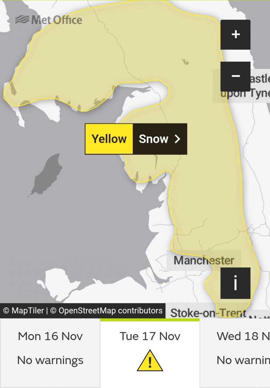
Met Office snow warning from midnight until 11am Tuesday
This wet and wintry (and for some windy) weather will be across northern England and parts of Scotland by around 6/7am as people head out to start their day. Inclement weather occurring in morning rush hour can bring more impacts than the same weather at 2am on a Monday night.
"Snow may cause travel disruption over higher ground early Tuesday." Met Office
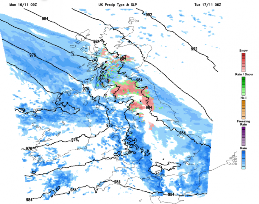
The UKV model showing hill snow at 6am on Tuesday and wider rain
We have cold air in place, milder conditions approaching from the southwest and a frontal band of rain. This is the first snow warning of the 26/27 winter season, although the Scottish mountains have seen some snow already this month. So part of this warning will be a reminder to those who live or commute over higher-level routes like the A66 or A69 to prepare before heading out early on Tuesday. To take warm clothes, a full charged mobile phone and to leave extra time for your journey.
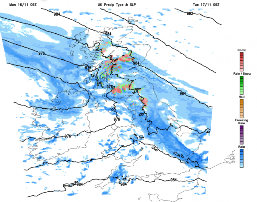
The 9am UKV precipitation shows further snow over the hills and mountains of Scotland and northern England, but elsewhere a lot of rain
For Tuesday morning, there will be a fresh easterly wind over Scotland with outbreaks of rain and hill snow. Northern Ireland will start the day with wet weather and a fresh SE wind. The southern Pennines, the Yorkshire Dales and the Peak District could see settling snow overnight into the early hours of Tuesday. The lying snow risk will be further north around dawn for the northern Pennines, the Southern Uplands and the Cumbrian Fells and perhaps for the highest parts of the M8. There will be a fresh to strong southeasterly wind on Tuesday morning to accompany this wet or snowy weather, adding to the difficult conditions for NW England and SW Scotland.
“Where snow does accumulate, depths of 1-5 cm are likely; some locations above 300-400 m could see 5-15 cm.” Met Office
Behind the main frontal band and the risk of sleet and snow, there will be a band of heavy rain and clusters of thundery showers. The wet weather continues for a time over Wales and then England, reaching London around 8/9am as even more people are on the move. It will be milder in the south, but there could be difficult conditions on the roads due to surface water and spray.
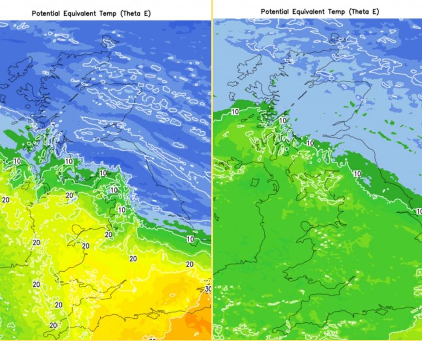
Mild air over southern Britain and Ireland on Tuesday, with cold air to the north. Not such a contrast by Wednesday but note the cold air away to the far northeast.
This week, the UK sits between cold Arctic air to the north and northeast and milder Atlantic flow over southern Britain. Tuesday will feel much milder for southern England in the sunshine. By the end of Tuesday, as temperatures reach the mid-teens inland, it will be hard to think of the northern hill snow mentioned in the forecast. It’s just worth watching a wave to the south. This will bring rain to northern France on Tuesday afternoon but could edge further north and spoil your journey home as well. Central parts of England could feel warm in the sunshine but this waving front brings uncertainty for the coasts of Sussex and Kent
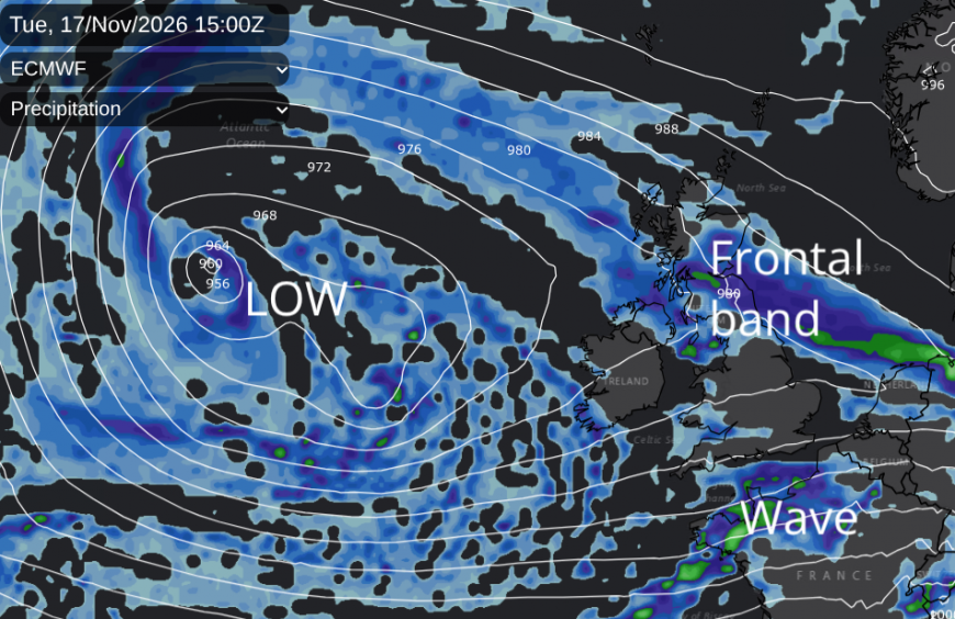
The low pressure will sit to the west of Ireland through the middle of the week, bringing showery outbreaks of rain but plenty of bright or sunny spells. There will be further rain overnight into Wednesday. There is more chance of seeing some sunshine over southern Britain but still with scattered showers, in a W/SW wind.
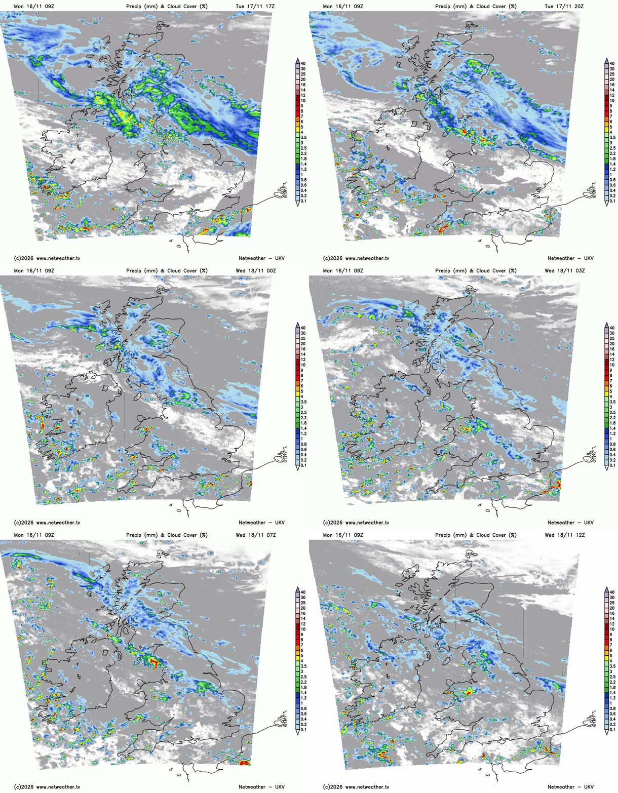
Further north there will be more cloud, outbreaks of rain and a lighter easterly breeze off the North Sea. Western Scotland will feel chilly in the brisk easterly. The far north of Scotland will be sunny, dry but cold.
Gradually, the colder Arctic air will reach southwards for the end of the working week. There will be some milder air holding on for Thursday over SW England with a line of heavy downpours, welcome rain but still showery in nature.
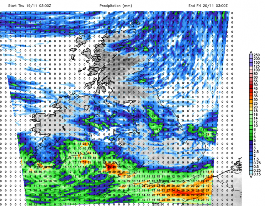
Much needed rain for southwest England
“We’re continuing to see the benefits of wetter weather after months of exceptionally dry conditions. There’s still a long way to go to rebuild our storage heading into next year... Thank you to everyone who is already saving water. Even when it’s raining, the water households and businesses save today helps ease pressure on supplies now and leaves more water in reserve for next year. Please keep using only what you need.” Richard Stanbrook, South West Water’s Drought Programme Director
Skies will clear from the north, with a frost for northern Britain by Friday morning and looking potentially frosty for much of the UK for the start of Saturday. It depends on how quickly the next Atlantic frontal system arrives from the west. Currently, there is a ridge of high pressure showing over Britain for Saturday morning, with a settled but chilly start to the weekend.
Loading recent activity...








