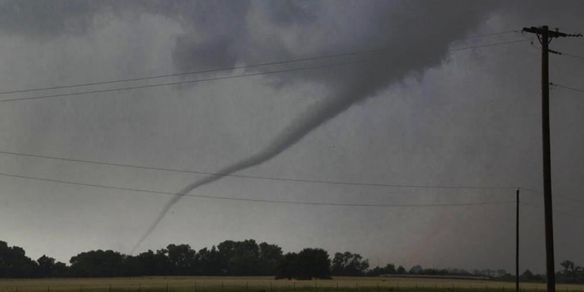
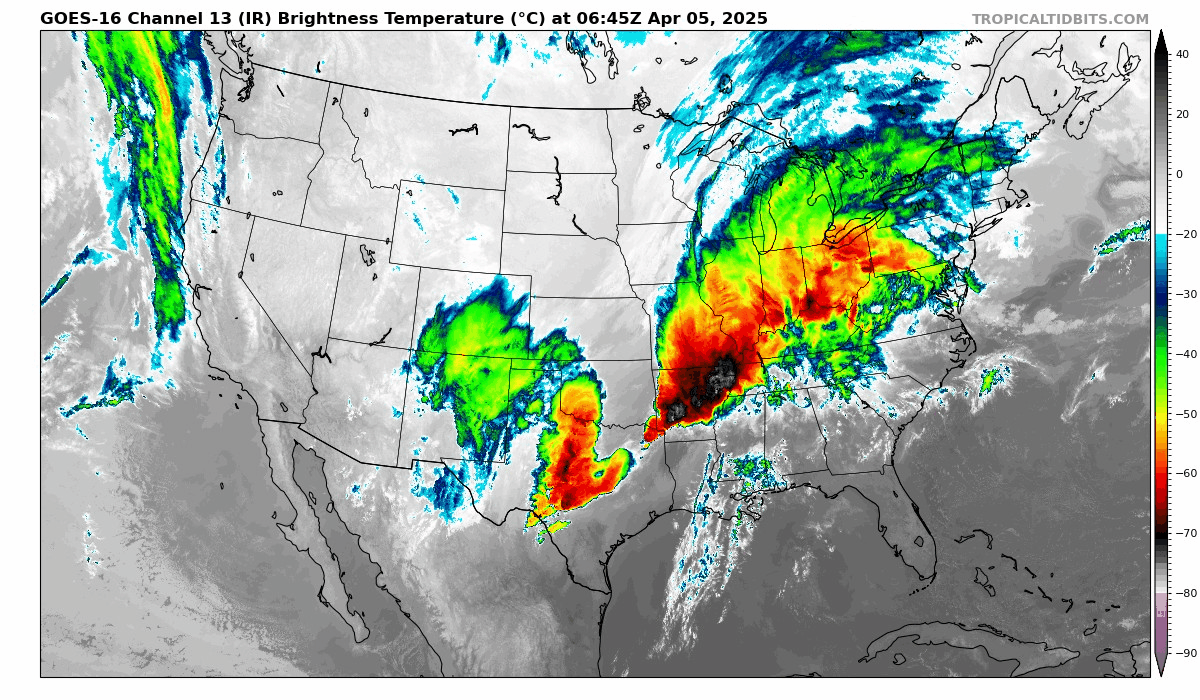
A stationary storm system over southern and central USA since mid-week has brought severe thunderstorms from Texas to Indiana which have unleashed deadly tornadoes and will now bring a historic flooding event across the same areas as flash floods continue over the weekend.
Severe thunderstorms, fuelled by a stationary atmospheric river, unleashed tornadoes, large hail, damaging winds and flash-flooding since Wednesday night from Arkansas in the Deep South to Illinois in the Mid-West. The storms with tornadoes rampaging across the central United States and mid-South destroyed homes, collapsed commercial buildings and flipped vehicles.
This is the Short Range Public Discussion from the US National Weather Service and details the pattern causing the severe storms and flooding over several days over the same areas:
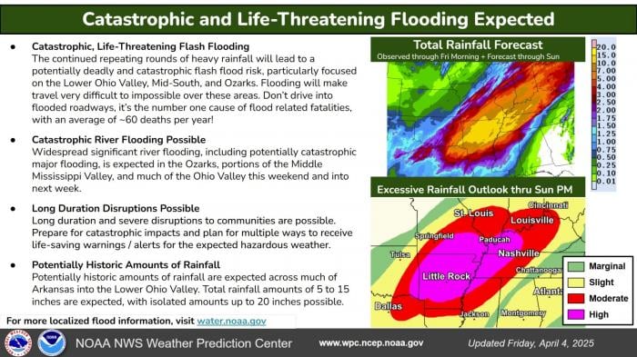
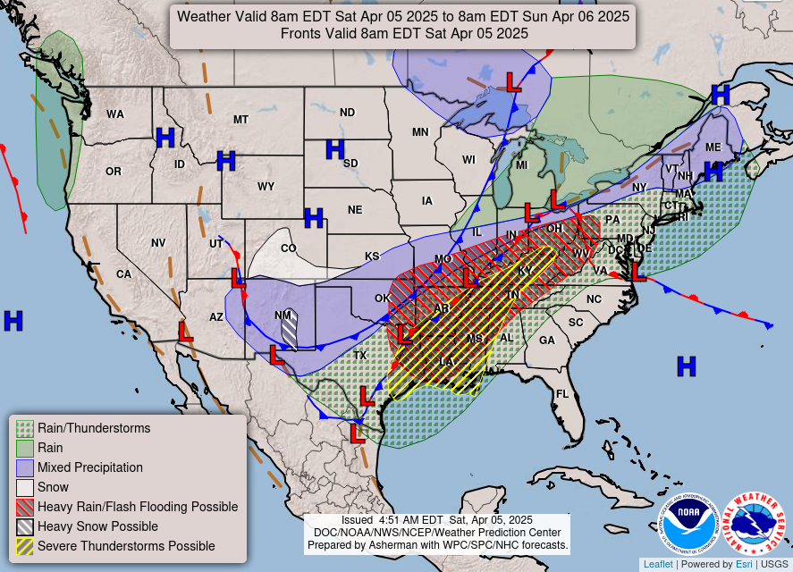
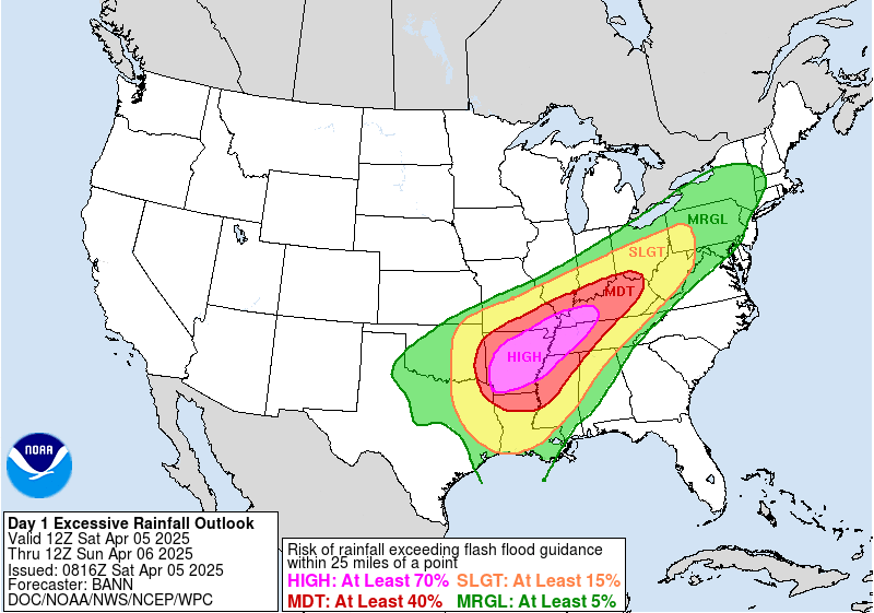
Several waves of low pressure acting on a nearly stationary frontal boundary will continue to be the focus for life-threatening flash flooding from the Lower Ohio Valley to the Mid-South to the ArkLaTex through Saturday. Deep moisture pooling along the front combined with impressive dynamics will set the stage for persistent rounds of intense thunderstorms capable of producing torrential downpours throughout the region. This will especially be the case for the Ozarks and Mid-South, where the best moisture, instability, and forcing overlap. Storm initiation and movement roughly parallel to the boundary will continue to lead to repeated rounds of heavy rainfall over the same hard-hit areas, leading to significant to extreme, potentially historic, rainfall totals over increasingly saturated soils. A High Risk (at least 70%) of Excessive Rainfall remains in effect through Saturday, highlighting an increasingly dangerous and life-threatening situation. Outside of the High Risk, Moderate and Slight Risks also continue to be in place over broader areas of the Ohio Valley into the south-central U.S. where scattered to numerous instances of flash flooding can be expected. As has been said repeatedly for the last several days, this has the makings of a catastrophic, potentially historic heavy rainfall and flash flood event, with some locations potentially seeing rainfall amounts as high as 10-20" when all is said and done. The repeating rounds of heavy rainfall will also likely cause many rivers to exceed their banks, with the potential for catastrophic major flooding across the Ozarks, portions of the Lower/Middle Mississippi Valleys, and the Lower Ohio Valley. Unfortunately, the risk of major river flooding will likely continue into early next week, long after the last drop of rain has fallen. The stalled frontal boundary finally begins to move late Saturday into Sunday, taking the axis of heaviest rainfall along with it. With the front on the move, the focus for heavy rainfall shifts eastward into parts of the Southeast on Sunday.
The storms have claimed the lives of at least eight people so far, with another round of severe thunderstorms, bringing tornadoes, large hail and flooding forecast for Saturday across the Deep South from east Texas across Arkansas, Louisiana, Mississippi to Tennessee.
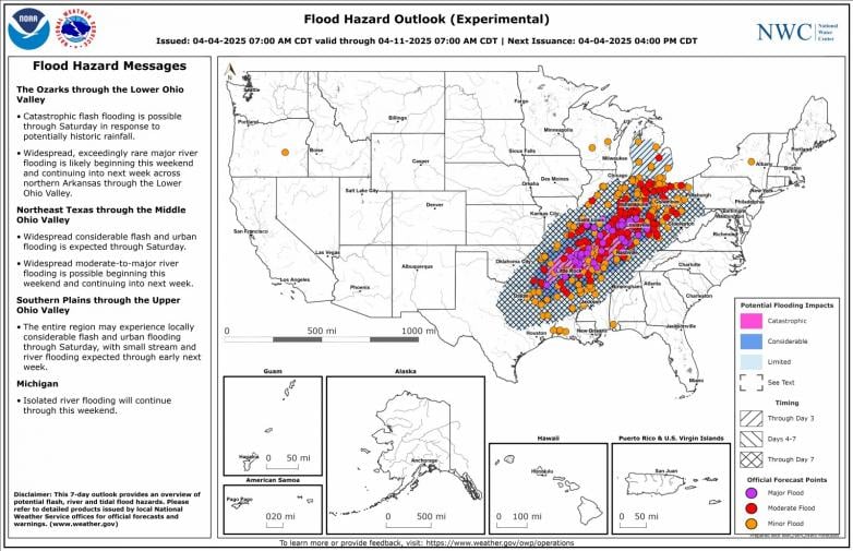
Some locations could potentially see rainfall amounts as high as 10-20 inches through the weekend, before the system moves out Sunday. As a result, the US National Weather Service is warning about "life-threatening, catastrophic, and potentially historic" flash floods across the Lower Ohio Valley and Mid-South to the Lower Mississippi Valley. Areas at risk include parts of northeastern Texas, southeastern to northwestern Arkansas, southeastern Missouri, southern Illinois, western Kentucky and south-central Indiana.
Round after round of heavy rains are expected in the central and southern U.S. through Saturday and could produce dangerous flash floods capable of sweeping away cars. Widespread thunderstorm activity is expected in the lower Mississippi Valley and into the lower Ohio Valley, with hail up to 2 inches, damaging winds and also a couple of strong tornadoes across Louisiana, SE Arkansas, eastern Mississippi and western Tennessee.
Atmospheric River of heavy rain and storms along stalled frontal boundary across southern and central US over recent days
On Saturday, the high-risk area for flooding will be larger than it was on Friday covering Arkansas into western Kentucky. Cities most likely to experience flooding from Saturday into Sunday morning include Little Rock and Jonesboro in Arkansas; Memphis in Tennessee; Poplar Bluff in Missouri; Paducah in Kentucky; and Evansville in Indiana. Louisville and Lexington in Kentucky, and Nashville in Tennessee, are also at a moderate risk for flooding.
Four months' worth of rainfall could fall in just five days across a 1,000-mile swathe of southern and central USA, resulting in numerous rivers and other watercourses bursting their banks. The amount of rain forecast to fall over these areas would exceed the 500 to 1,000-year average.
Loading recent activity...