After a cold start to 2025, with snow, widespread ice and the coldest January night since 2003, milder air is on its way. However, prepare for the return of anticyclonic gloom as cloud and fog replace the cold.
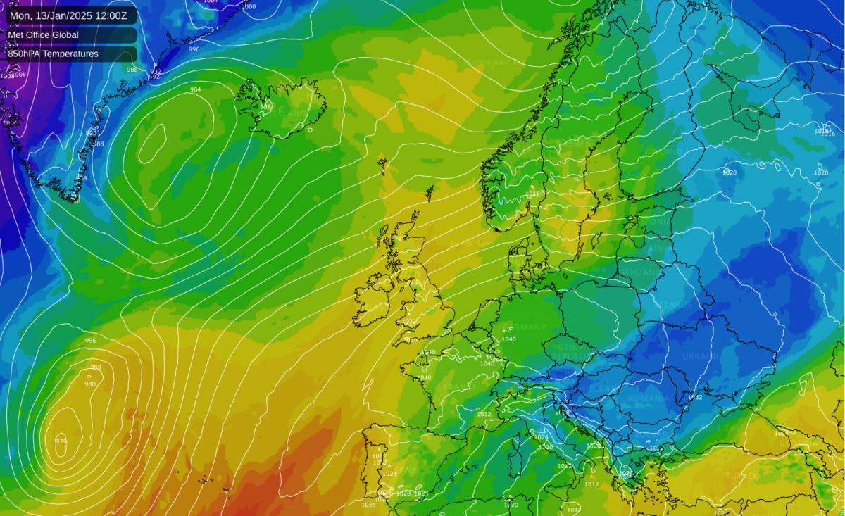
Many of us have had another cold night and cold frosty start, with some fog patches in places, but milder air is on its way. High pressure will remain close by, mainly centred to the south of Britain, allowing a relatively mild and moist west to south-westerly airflow to establish by next Tuesday. The milder air will start to push into most areas by Monday. It is forecast to be cold again tomorrow, though probably not as cold as today, especially overnight.
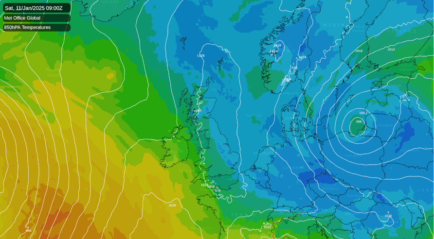
The change will probably bring about plenty of anticyclonic gloom, especially in the south of Britain, because the air mass will be very mild at high altitudes but not so much near the surface, which will tend to result in low cloud trapped underneath an inversion. Fog may also be quite widespread at times in the south. However, with a mainly west to south-westerly airflow during next week, some sheltered eastern areas, especially in eastern Scotland and north-east England, can expect to see a fair amount of sunshine, as the cloud sheet will tend to break up in the lee of high ground such as the Pennines and the Scottish Highlands.
High pressure is forecast to drift further north towards next weekend, probably transferring the cloudy weather into north-eastern areas and bringing temperatures close to the seasonal average.
Ice has been widespread for many regions during the past week. For areas affected by snow cover, ice has resulted widely due to the wet nature of the snow - many areas had a mix of sleet and wet snow, resulting in slushy conditions - followed by sharp night frosts. When snow cover undergoes a thaw, turns slushy, and sharp frosts follow, it turns the snow cover to ice. Ice was less of an issue for many during the very cold spells in January and December 2010 and in January 2013, because the snow events of those months were often relatively dry and powdery due to the snow falling at temperatures around or below freezing. As a result, the snow was less inclined to turn to solid and slippery ice even when frosts followed.
Locally where I was, there was no sustained snow cover, but there was flooding nearby and puddles formed quite widely in areas of undulating terrain, due to a mix of heavy rain, sleet and snow last weekend and into early last week. Where the flood waters were shallow, they froze over mid to late week, resulting in very icy and slippery conditions on roads and (especially) paths. Some of the overnight frosts have also resulted in white ice forming widely. Often, though, black ice is the most dangerous because it is harder to spot, and there has been some of that as well.
Global temperature records have been coming in during the past week and have unanimously been giving 2024 as the warmest year globally in records going back to the mid to late 19th century. 2025 is not forecast to be as warm globally due to the lack of an El Nino event and potential for a weak La Nina, but it is still expected to be third warmest after 2023 and 2024. For the UK as a whole, and for Central England (in the Central England Temperature series from 1659), 2024 was not as warm as 2022 or 2023, but it was generally in the top five warmest years.
I have been thinking that in some of the areas where snow cover turned to solid ice, particularly in the north of England, it may have ended up less icy had this cold spell happened a few decades ago, because in that case the precipitation would have fallen more exclusively as snow and at lower temperatures, resulting in drier and more powdery snow that would not have turned as readily to ice during the subsequent frosts. However, during our less intense cold spells, it can also work the other way, and we may sometimes avoid icy conditions in cold snaps or spells today that do not produce sharp frosts to the extent that they did in the past.
Last night officially saw a minimum temperature of -18.9C at Altnaharra in Sutherland, which was equal to the lowest temperature recorded in the UK in January 2003.
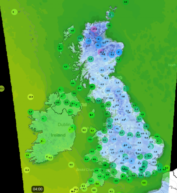
Since 1988, only 2010 has produced a lower minimum temperature in January, although February 2021 saw the temperature fall to -23.0C at Braemar during a cold easterly spell. This reflects the relative lack of intense cold spells during January in recent years, as well as the long-term warming trend in the climate.
Milder weather starting on Monday or Tuesday will reduce the extent to which the first half of January as a whole turns out exceptionally cold. However, overall temperatures are forecast to not rise far above the seasonal average next week, and some areas of the UK, and maybe the UK as a whole, look likely to end up with their coldest first half of January since the exceptionally cold first half of January 2010.
Loading recent activity...