We're set in a very stable pattern as we head into Christmas, with high pressure to the south of the country, keeping Atlantic fronts at bay for the majority, and drawing up very mild, but moisture laden air across the country.
With the mild air in place, this Christmas is shaping up to be one of the warmest on record, certainly for parts of the UK. Northern Ireland has seen its warmest Christmas Eve on record, reaching 14.3C at Magilligan on County Londonderry, beating the previous record of 13.9C, set in Armagh in 1942.. Meanwhile, the highest temperature today of 14.5C, reached at Aberdeen Dyce early this afternoon, is a degree lower than the warmest Christmas Eve on record for the UK - which currently stands at 15.6C, measured at Gordon Castle in Banff and in Craibstone, Aberdeenshire, in 1931.
To be the warmest Christmas Day, somewhere will need to beat the current record of 15.6C reached at Killerton in Devon, way back in 1920. The record high for Scotland for Christmas Day stands at 15.1C in Dyce, Aberdeenshire in 2011 and Urquhart, Ross and Cromart, in 2016.
Tomorrow will be another unseasonably mild day, temperatures widely reaching low double figures, perhaps not as mild as today, but temperatures still reaching 11-12C widely. Locally reaching 13-14C, particularly to the lee of high ground like today, such as NE Wales, NE England and eastern Scotland, with the foehn effect of the mild southwesterly wind descending the mountains towards the coast causing temperatures to rise. Though it looks like we won’t beat the Christmas Day record of 15.6C, some places could see temperatures some 5-6C above the average high for late December.
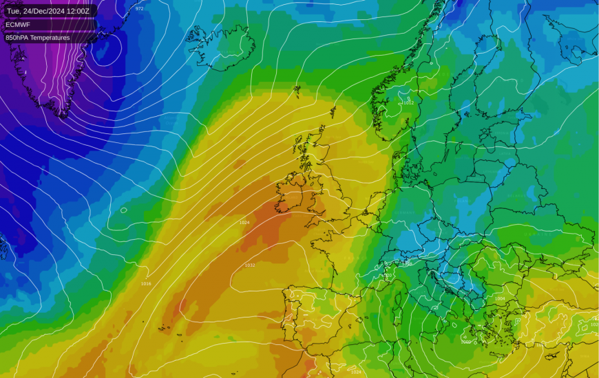
The very mild air across the British Isles at the moment is being drawn from way way to the southwest from the sub-tropical mid-North Atlantic to the southwest of the Azores. The air warming further locally in the lee of high ground as the air descends and warm katabatically (aka the foehn effect) - bringing temperatures a few degrees higher than elsewhere.
As well as the bringing mild air, the long-draw southwesterly flow will bring a lot of moisture, so it will be cloudy and murky for many on Christmas Day, cloud thick enough for some drizzle in the morning, while NW Scotland will be windy with spells of rain. The cloud will lift to allow some brightness or glimpses of sun across central and eastern areas of the UK into early afternoon. With many staying dry in the east.
The generally quiet weather, with high pressure in charge close to the south, will continue on Boxing Day. England and Wales will be mostly dry if rather cloudy at times, but some breaks again may allow some sunny spells across southern and eastern areas. Scotland and N. Ireland will see a weakening cold front slip south bringing some patchy rain, before the front moves back north again.
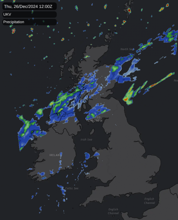
Friday looks to see a waving frontal boundary over Scotland reinvigorate with heavier spells of rain developing along it across the west before the front moves back southeast again on Saturday, eventually bringing thicker cloud and patchy rain across England and Wales, though little if any rain reaching the southeast. Turning windy and unsettled in the north on Sunday - perhaps with spell of heavy rain and gales moving through Scotland. Drier with sunny spells in the south.
Turning colder across Scotland later on Sunday and this could set the stage for north-south divide as we see out the year and welcome in the start of 2025, with cold arctic with a risk of snow at times affecting Scotland and perhaps N. Ireland and northern England early next week, while the south remains milder with spells of wind and rain a times. A chance the colder air may move further south across all parts through the week, bringing the threat of snow further south, but uncertainty over this. Northern areas favoured for cold and wintry weather next week, the south perhaps staying mild. But we will keep you updated on the possibility of wintry hazards spreading south next week.
Loading recent activity...