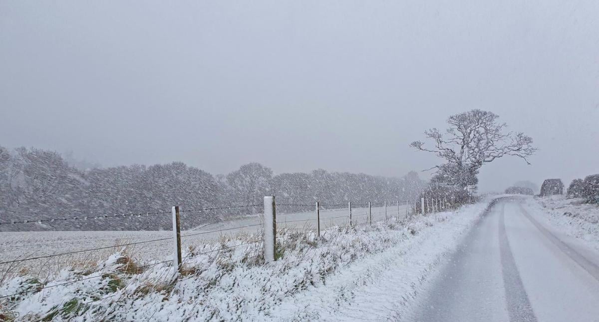
A northerly wind will develop on Sunday and into early next week, bringing down cold arctic air across the British Isles. There will be a temporary milder blip on Monday across southern areas, as an area of low pressure moves southeast across central areas later in the day, bringing outbreaks of rain and windy conditions to Wales, southern England, Midlands and East Anglia. But on the northern flank of the low, sleet and snow is more likely as the system bumps into the cold air filtering down from the north.

The exact location of the boundary between rain and snow may shift further north or south, but the Met Office has yellow warnings in force for snow and ice across southern parts of Scotland and northern parts of England between Monday 1000 - Tuesday 1000. Snow will settled mainly over the hills, but may temporarily at lower levels too Monday night.

Also there is a separate yellow warning for snow and ice across northern parts of Scotland between Sunday 1600 - Monday 1100. Here sleet, hail and snow showers will become frequent from Sunday evening, accumulation mostly over higher ground by day, but may settled at lower levels overnight.
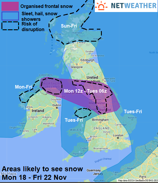
Once the low and its rain, sleet and snow moves away east, all parts will be back into an increasingly cold northerly or northwesterly flow for the rest of the week. It will be mostly sunny but cold inland, with a risk of widespread overnight frost, but across northern Scotland and along windward coasts of N. Ireland and western parts of Scotland, England and Wales - there will likely be scattered sleet, snow and hail showers throughout the week. Perhaps merging into longer spells with any troughs in the flow. Again accumulation most likely over hills but temporarily at lower levels too away from immediate coasts.
As we head into the colder months, one thing can be relied on is the appearance of some eye-opening and sometimes misleading tabloid news headlines about snow. A favourite of these news article headlines is to mention the amount that will fall on an exact date.
Yesterday’s Birmingham Mail had a headline of ‘UK faces 18 inches of snow with foot and a half being dumped’. A few days ago, the Daily Express had a ‘200-mile snow bomb unloads on Britain’. Yesterday the Express had ‘Met Office pinpoints exact areas where snow could fall this weekend - full list‘.
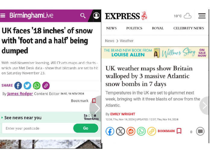
The media know news about snow draws in the views and gets people talking, so often use eye-catching headlines to grab reader attention, often referred to as ‘clickbait’ if the article is online, as the excitable headlines entice people to click on the thumbnail or link to go to the page to find out more. Words often used are ‘snow bomb’, ‘100/200/500 mile wall of snow’ or ‘the exact date snow will fall’.
But the complexities of forecasting snow, especially at long ranges, means that these kinds of headlines mentioned above can often be misleading or downright wrong.
British people tend to approach weather forecasts of snow with a combination of excitement and trepidation. Snowy scenes, especially in the run up to Christmas, conjure up the Charles Dickens scenes we see on Christmas cards, get people feeling more festive and also snow can be fun for children to play in and brings out the child in some adults too.
But also there is the inconvenience of snow that often occurs in the UK, as often we aren’t prepared to deal with more than a few inches – so there is the inevitable disruption to travel along with the risk of falls on ice and accidents on roads when the snow compacts and freezes overnight. Elderly are particularly vulnerable to icy conditions and also the cold that comes with snow can take its toll, particularly now many pensioners will not receive the winter fuel payment.
Forecasting snow is tricky in Britain, with any predictions of where and when it will fall tending to be uncertain, even a day before or sometimes on the day itself. If you are an adult and have been fascinated by snow since a child, you may go to bed excited by forecasts for snow to fall overnight to make a wintry wonderland only to wake the next morning greeted by rain, green and grey outside.
There are a number of factors that can cause make forecasting snow tricky and make the fine line between snow or rain a challenge to forecast
Airmasses
The UK’s weather is influenced by its geographical location and the surrounding seas. In the colder months of the year (November to April) - the UK is often a battleground between cold, northerly, or easterly winds and milder westerly winds. This creates an unpredictable winter climate compared to interior continental countries well away from the influences of warmer seas. So UK weather forecasters must consider these competing airmass to predict snow accurately. The variability in weather patterns makes it difficult to predict snow confidently, leading to uncertain forecasts.
Local geography
Local geography also plays a significant role in snow forecasting. Areas with higher altitude tend to experience more snowfall due to colder temperatures higher up. Coastal regions, influenced by the relatively warm seas when the air is cold, might see less snow due to the moderating effect of the sea surface temperatures on air temperature. Predicting snow in the UK requires a detailed analysis of these local climatic variations.
Heaviness of precipitation
Precipitation lowers the air temperature through a process known as evaporative cooling. The heavier the rain the more the temperature drops. Heavier rain is more likely to turn to sleet than snow, than lighter rain, if temperatures are only a few degrees above freezing near ground level.
Wind
When the situation is very marginal for snow to fall, with temperatures a few degrees above freezing when precipitation arrives, wind or lack of can make a difference between rain or snow. Light winds or calm conditions favour faster evaporative cooling, as the air is not mixed out by less cold air like it would if it is windy.
Temperature amd moisture profiles
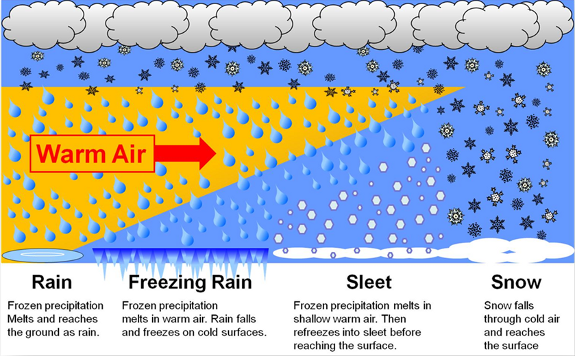
The air at ground level needs by 0C or below for snow to settle, but snow can fall with air temperatures a few degrees above freezing, but the air needs dry enough for snow to fall, with the dew point ideally at or below 0C. If it is 1C or above, rain or sleet is more likely to fall. Also, for snow to fall from the clouds and not melt on its way down, temperatures need to be below freezing above the surface layer. If there is air above 0C higher up, then rain will fall. If this rain falls into a surface layer that is 0C or below, then there is a risk of freezing rain.
Boundary between cold and mild airmasses
There’s often a fine line between who see snow and who see rain, particularly when frontal boundaries are involved, which is one of the reasons forecasting snow can be difficult. It can only be a difference of a few miles from a milder airmass and rain over the boundary into a colder airmass and snow. Forecasting exactly where this boundary is at particularly times in the day, when often the boundary can move, can be challenging. So. often forecasters err on the side of caution if there is uncertainty about positioning of boundaries.
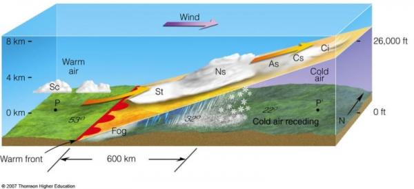
Because of these competing elements, accurately forecasting a specific snow event more than a few days in advance is a tricky task.
Loading recent activity...