November is the wettest month of the year on average across large parts of the UK, but like now, high pressure can hang around for a few weeks bringing a dry weather but sometimes grey skies. But it's not often it happens.
No sun, no moon!
No morn, no noon
No dawn, no dusk, no proper time of day.
No warmth, no cheerfulness, no healthful ease,
No comfortable feel in any member
No shade, no shine, no butterflies, no bees
No fruits, no flowers, no leaves, no birds!
November! - Thomas Hood (1844)
The above poem was written by the British poet Thomas Hood in 1844, and with the anticyclonic gloom recently and throughout the coming week, many will probably share his sentiments about this often gloomy month.
At the time the above poem was written, the gloom of a cloudy and chilly November day was probably more noticeable than it is now, with our well-lit and well-insulated centrally heated homes and offices – which allows to distance ourselves from the outside world. Back in 1884, it was a different world with no electric light and central heating, instead they relied on oil lamps, candles and wood or coal fires to keep light and warm.
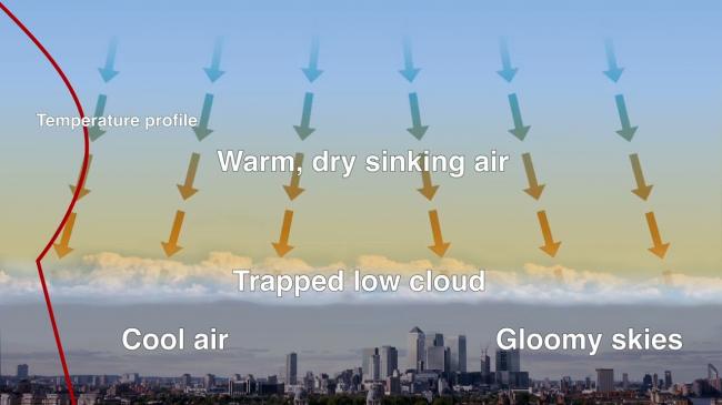
The end of October and the first five days of this month have been particularly gloomy for many, thanks to a blocking high pressure system trapping a layer of moist air under an inversion. This where there is a layer of mild air aloft and subsiding air from high up, which also warms the air aloft, preventing air from rising trapping moist but cool air at the surface which forms a layer of cloud between it and the milder air above. And with little in the way of wind to stir the air and break up the cloud and not enough energy from the weaker sun now to burn off the cloud, as it does in summer, with cloud stubbornly holding on all day in many areas.
 Source: Royal Meteorological Society (RMetS)
It is quite unusual for November to be quiet and still under the influence of high pressure. November is more likely to be wet and windy than any other month of the year. In fact, for many locations, November is the wettest month of the year, and in the UK as a whole, on average – just beating October and December. This is thanks to the predominance of westerly winds, with Atlantic low pressure systems moving over or close to the UK.

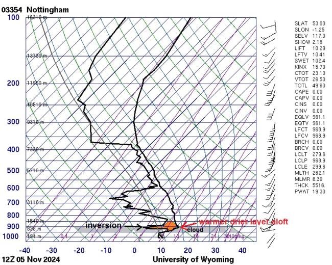
Nottingham (Watnall) radiosonde baloon ascent at midday today shows an inversion above 950 hPa (above roughly 500m high) - which traps cool and moist air below relatively warm air aloft - creating blanket of cloud.
In some places there is now twice as much sun in November as there was a century ago. London has seen an increase from 30 hours on average to 74. A large part of this is down to a reduction in smoke pollution from heavy industry and many homes burning coal in cities before the widespread introduction of gas central heating in homes and also a decline in heavy industry. The Clean Air Act 1956, which was an Act of the Parliament of the United Kingdom enacted principally in response to London's Great Smog of 1952, helped clean the air in cities. But also there was a change in weather patterns since the mid-1960s, with an increase in clearer northwesterly or northerly winds and decrease in easterly or southerly winds in November.
The most recent mostly anticyclonic and dry November was in 2021, much of southern Britain had a dry month with high pressure more often than not in charge, though it was wetter at times in the north closer to high pressure. The UK saw 63% of the average November rainfall, though much of southern and southeastern England saw less than a quarter of the average rainfall, while England saw 45% of the overall average November rainfall.
2013 saw a dry November, though it was cold and sunny too, England and Wales saw 61% of the average November rainfall, while sunshine was 123% of the average.
2011 was a dry but warm November. England and Wales recording 53% of the November average rainfall, though it was particularly dry in parts of eastern England, with Bridlington recording only 11mm all month.
1988 saw a particularly dry and anticyclonic month across much of the UK, parts of southern and southwestern England seeing less than quarter of the average rainfall. The month was often cold at night with frequent fog.
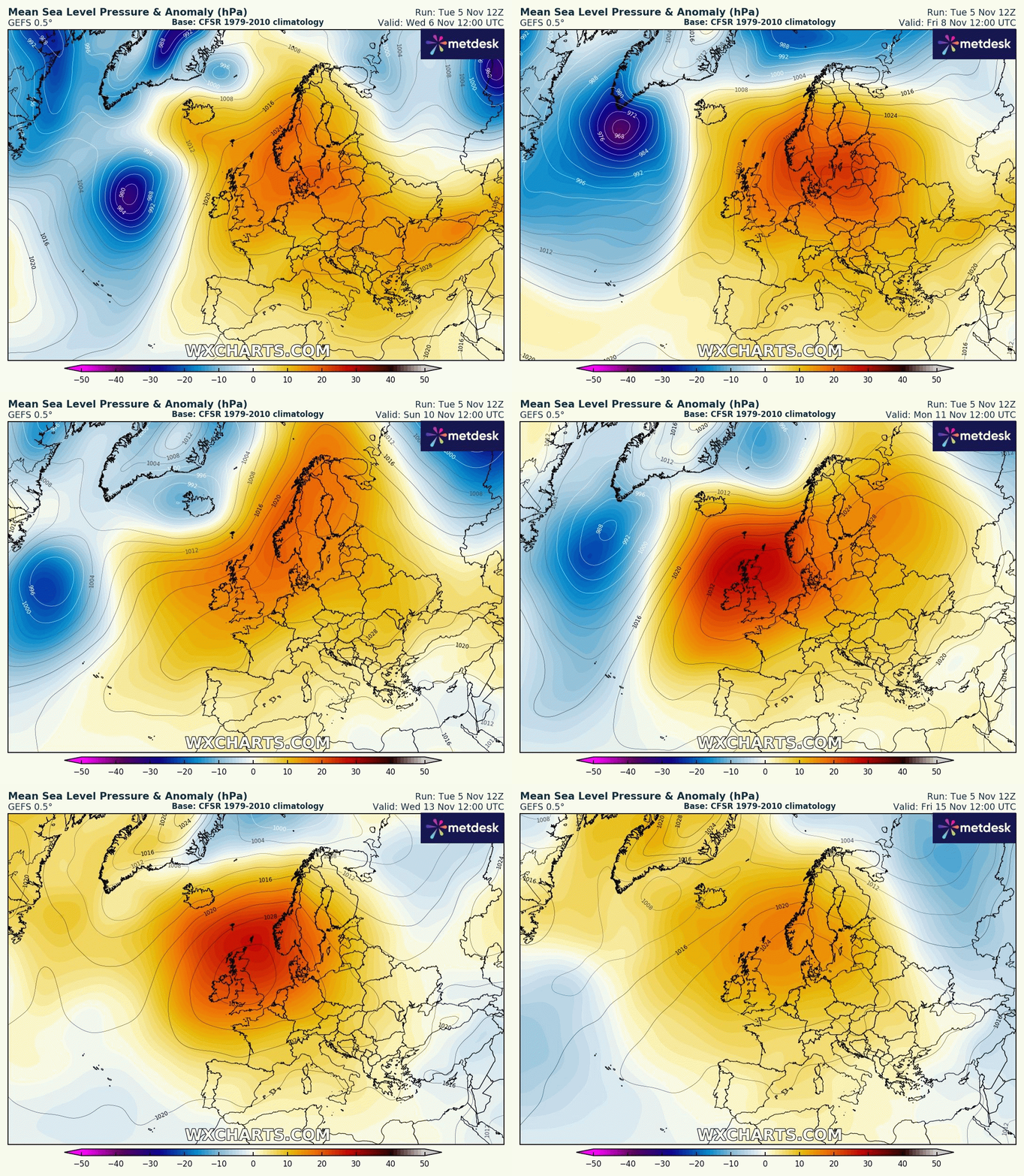
No real sign of a pattern change out to at least mid-month. High pressure looks to remain close by for the rest of this week and through next week too. However, it will often be cloudy, though there will be some breaks allowing some bright or sunny spells, as we have seen in parts of southeast England and Scotland today and yesterday.

Over the weekend, Atlantic weather fronts moving in off the Atlantic look bring some rain into western areas on Sunday, before fronts move east and weaken, bringing thicker cloud and some patchy light rain or drizzle. Then into next week, high pressure looks to build back in, bringing mostly calm, dry but possibly cloudy weather for much of the time, depending on where the high positions. Drier air may be drawn in across parts of the UK - which would allow clearer skies. But uncertainty this far out. If skies do clear at night, there is a risk of fog.
Loading recent activity...