Tropical hurricane Milton closes in on Florida for Wednesday night. Ex-hurricane Kirk (now an extratropical low) drenches France leaving a cold northerly wind behind for the UK.
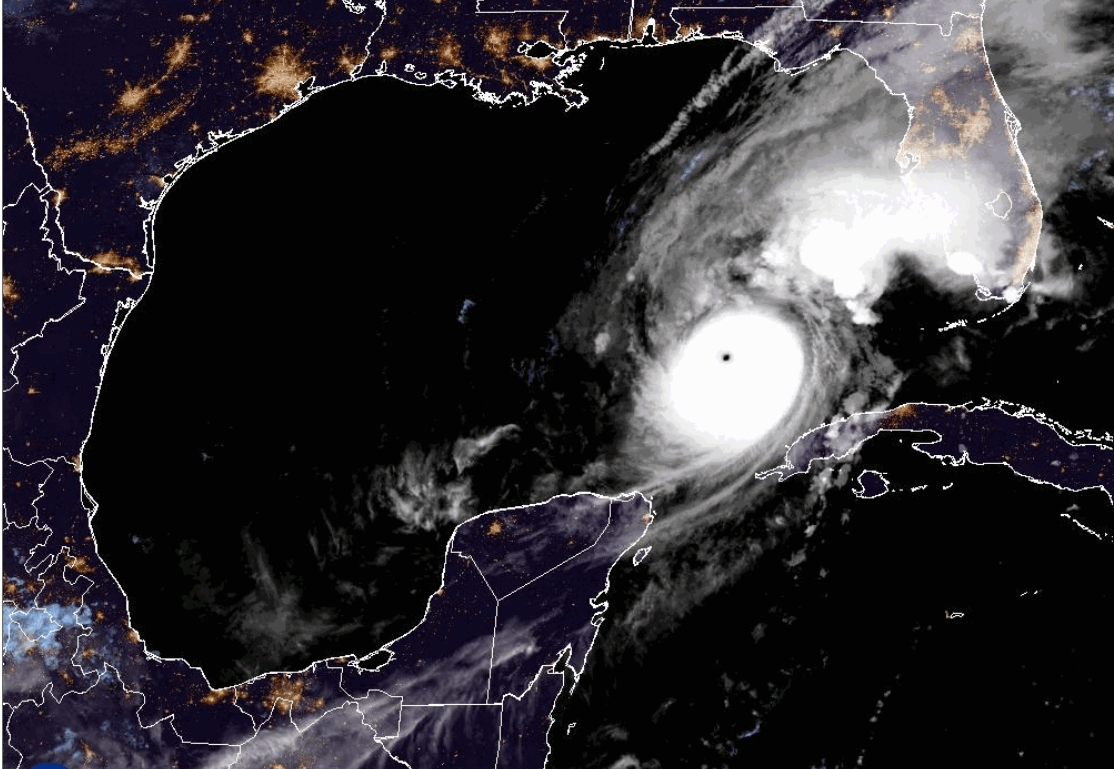
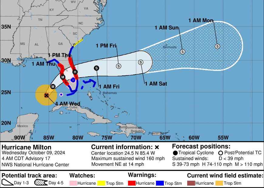
‘Hurricane Milton’ is in the Gulf of Mexico heading straight towards Florida. Even across the Pond, there has to be a sense of dread and foreboding as this monster churns towards The Sunshine State. It is hard to imagine how the people under evacuation orders have been faring. This has been a busy week and people were warned to leave before today.
"Milton has the potential to be one of the most destructive hurricanes on record for west-central Florida." NHC “MILTON is forecast to make landfall on the Gulf Coast of Florida late tonight as a dangerous Major hurricane…weather conditions are expected to begin deteriorating this afternoon.”
An extremely dangerous hurricane, it has fluctuated between a Category 4 and the top level Category 5. The Saffir-Simpson Hurricane Wind Scale starts with wind speeds of 74 mph and looks at wind strength impacts. However, there are other significant impacts. Heavy rain can also cause widespread flooding and landslides, tornadoes are produced, and the storm surges from these beasts can be more lethal than anything else.
Recent Activity
The Atlantic season sprung into life in recent weeks. Hurricane Helene arrived in the northwestern part of Florida, bringing devastation inland after exceptional rains and flash flooding that carved away roads, villages, and other infrastructure. The southern Appalachian region is still a mess and the States affected would be places that people from northern Florida usually flee to. Closer to Tampa Bay and Floridians continued to load up debris from Helene’s wind and storm surge damage as they were being told to evacuate for the next hurricane.
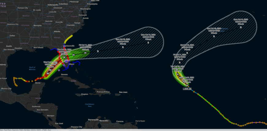
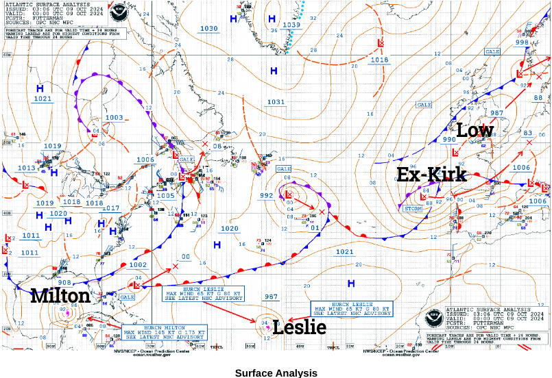
Hurricane Leslie is swirling away out in the mid-Atlantic but isn’t troubling anyone. It might send some wet and windy weather over the Azores early next week but for now, Leslie can be ignored.
‘Associated with the Kirk depression (low), heavy and lasting rains in the Pays de la Loire, the Paris region and Champagne-Ardennes. Very strong southerly wind over the west of the Pyrenees and Lyonnais, which can sweep across the plains and into the valleys.’ Vigilance France
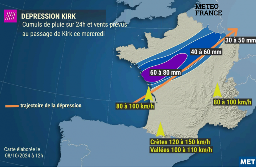
In Europe, ex-hurricane Kirk is moving over the Bay of Biscay. Meteo France has a rash of warnings for heavy rain, flooding and high winds for Wednesday into Thursday. A week ago there were concerns that this low pressure could impact the UK with wet and windy weather but its track (after transitioning from Tropical cyclone to extratropical Low) has moved closer to NW Spain and then central France.
The UK has its own low pressure midweek which is bringing some blustery and showery weather but a cold northerly flow will follow. There certainly won’t be anything tropical in that wind by Thursday morning. As Ex-Kirk heads off over the Low Countries towards the Baltic Sea a brief nose of high pressure will bring fine autumn sunshine to offset the cold air in the UK on Thursday. There will be a few showers about but more by Friday for Scotland including snow over the mountains.
What next for Hurricane Milton?
It has taken an unusual track, moving eastwards toward the west coast for Wednesday night, throwing torrential rain and a storm surge at the northern coast of the Yucatan peninsula, Mexico. It is forecast to forge its way right across Florida. There will be immense hurricane-force damaging winds. Torrential rain will cause flooding but it is the angle of approach, the existing saturated ground, the building decisions and topography, the likely boost from Climate Change, that pave the way to what could be a historic landfall event as the storm surge arrives. It is already the 4th strongest Atlantic hurricane on record. Already the power in the Gulf of Mexico from Milton has entranced scientists looking at Milton’s structure and development.
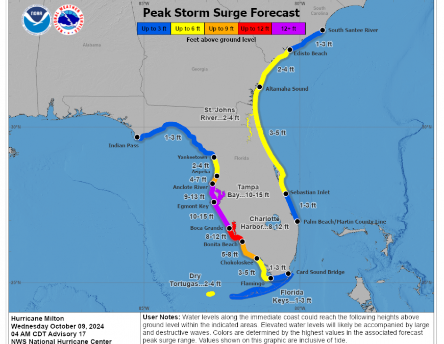
The storm surge map shows the coastal regions where this wall of water could arrive, there are variations depending on high and low tides but also coastal susceptibility variations. Imagine packing up your home, family and pets to evacuate. Looking out into the ocean as you leave, the sea that will come tonight and tomorrow to submerge the houses, shops, businesses, schools and roads that you are familiar with. Retreating to leave mud, sewage and widescale severe damage.
Hurricane Milton Netweather community forum.
Loading recent activity...