Heavy rain and storms associated with storm 'Boris' have left catastrophic flooding from Germany to the Balkans, with the Czech Republic, Yugoslavia, Romania, Hungary, Austria and Poland in particular declaring national emergencies. Several people have already been killed, with many missing under torrents of water that have washed away property and bridges.
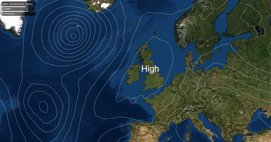
Fortunately for northern and western Europe, including the British Isles, we have much higher pressure, with a large anticyclone 'smack bang' over Britain today giving lots of fine, dry weather for the start of the working week. But later in the week, the anticyclone transfers to the North, letting in some of those showers from the nearby continent. These will chiefly affect the southern half of England and Wales, while further North, closer to the anticyclone, it should stay mostly fine and dry.
Vestiges of yesterday's rain over central parts are still giving cloud across southern areas, but this will soon move away. Then, with a large anticyclone dominating the scene, much of the country can expect to be fine and dry today. There'll be a fair amount of warm sunshine, although Northern Ireland, particularly towards Donegal, will see cloud increasing on a southerly breeze, but most of the province should stay dry. A northerly breeze towards Kent could also bring the odd passing shower.
It's a chilly start for some, with a touch of grass frost in rural valleys of East Scotland and towards the Scottish border. Only 2C first thing at Eskdalemuir and Redesdale Camp. There's also some mist and fog to get rid of, especially around the Welsh marshes, but this will soon clear in the still quite strong September sunshine.
Mostly light winds will make it feel pleasantly warm by the afternoon, with maximum temperatures ranging from 15 to 18C in the North and 20 or 21C, locally 22C, in the South.
The Western Isles and the far North of Scotland will see some rain or drizzle after dark, making it misty, with some hill and coastal fog. But skies will break across Northern Ireland to leave a dry night here. Elsewhere, it remains dry after a fine early evening, with clear spells overnight. Light winds allow mist and patchy fog to form again towards dawn, but with a North or North Easterly breeze developing across the South East that may bring some cloud later in the night, especially towards North Sea coasts.
Lowest temperatures 5 to 8C, but lower than this in some rural valleys of the North and West, perhaps giving a touch of grass frost again briefly around dawn.
Much of the country remains fine and dry towards mid-week, but later and more particularly towards the weekend, the threat of showers from the South becomes more acute. An East or North East wind will also freshen, bringing quite gusty conditions and variable amounts of cloud to the East and South.
Loading recent activity...