31.9C at St James's Park in London remains the highest temperature recorded in the UK so far this summer, which could be broken locally in the Eastern England perhaps today but more likely tomorrow. This is because a deep trough in the 'jet stream' just to the west of our shores is allowing a plume of hot air from Iberia and France to move in across England and Wales around a depression moving north to the west of Ireland.
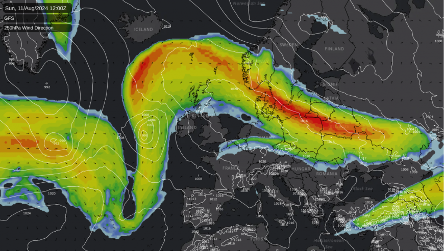
The heat also coincides with one of Alexander Buchan's warm spells. Buchan, a renowned 19th-century Scottish meteorologist, took a keen interest in weather events that tend to occur about the same time most years. But this particular singularity will be short-lived, with a thundery breakdown overnight and tomorrow across the North and West. Tuesday brings more heat to the South East, with the rest of the week still warm towards the South East but breezier and more unsettled.
For large areas of the country it'll be a fine summer's day with lots of sunshine. Apart from a few showers or storms that may break out later across Northern Ireland and in the far West, it'll stay dry.
Top temperatures 19 to 23C over Scotland and Northern Ireland, but only 15 or 16C in the far North. But in central and southern parts you'll notice it turning increasingly humid, as temperatures reach a hot 25 to 28C quite widely, with 29 or locally 30C possible to the north and west of London. A south-easterly wind will freshen a little across Northern Ireland, with an east wind developing in the South.
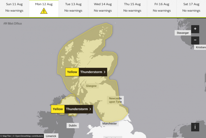 Met Office warnings issued for Thunderstorms overnight and into Monday
In a difficult night for sleeping across England and Wales, temperatures may not fall below 20C across some parts of the South, with 16 to 18C a more general minimum. But here, apart from a few perhaps sharp showers in the West, it should stay dry with clear spells in an east or south-easterly breeze.
Over Scotland after some clear spells in the East and across Northern Ireland, a freshening south-easterly wind will be bringing an increasing number of showers as fresher air begins to move in from the West. Thunderstorms, some severe, will give local torrential downpours and gusty winds bringing the risk of 'flash' flooding, although not everywhere will see them. Lowest temperatures 13 to 16C.
In stifling heat, the new working week sees sunshine across East Anglia and the South East lifting temperatures to a sizzling 33-34c or maybe even as high as 35C to make it the hottest day of the year. Most parts stay dry, although Norfolk may see the odd shower or storm later. Apart from the odd sharp shower over Wales and the North Midlands, the South should also stay dry, with fresher weather moving into the West later.

Elsewhere showers with embedded thunderstorms are more likely, giving gusty winds, local torrential downpours and the risk of 'flash' flooding. But across Northern Ireland, a west or south-west wind will give a fresher day of sunny spells and the odd shower, before rain and freshening winds move in from the West after dark. Elsewhere showers and storms move away from the North and East to give a fresher night for most, but it remains warm and humid towards the South East.
Loading recent activity...