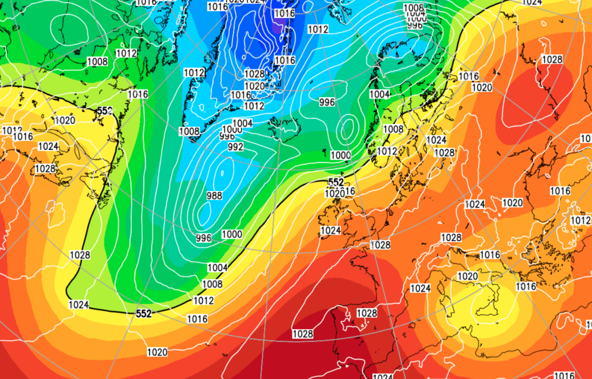
Storm Kathleen is with us this weekend, but into next week, the jet stream is set to shift. High pressure will build to the south of the UK, changing the pattern.
The jet stream has often been running to the south of its most common position in recent months, hence the frequent rain for most of the UK. At the same time, the almost unrelenting train of depressions has prevented the southerly tracking jet from allowing much in the way of cold northerly and easterly winds to penetrate south of northern Scotland. However, this is set to change during the coming week, with high-pressure building to the south and south-east of Britain and the jet stream moving to a more traditional position, with low-pressure systems tracking to the north of Scotland. This means that for most of the country it will become drier and more settled, especially towards the south-east. Conversely in north-west Scotland, which has often been relatively dry and sunny recently, it will often be wetter and windier than of late.
For now, though, Storm Kathleen is upon us, bringing strong winds, especially to western parts of Britain, where there will be gales around exposed south and west-facing coasts and hills. The depression will also trigger a plume of unusually warm air for early April, coming up from the south and especially affecting France and then spreading into central Europe on Sunday. Eastern England will lie on the western edge of this warm air mass, which means that it is probable that 20C will be exceeded, particularly in East Anglia.
A band of rain will swiftly move eastwards through Wales, Scotland and northern England during the rest of this morning and the early afternoon, but it will fizzle out as it moves eastwards, so some parts of eastern Scotland and north-east England will see no rain from it. Following behind will be a mix of sunshine and scattered blustery showers, with Northern Ireland and western Scotland collecting the majority of the showers. The frontal system and associated high cloud will make only slow progress through central and southern England. Still, it will push into East Anglia during the afternoon, resulting in the weather generally clouding over. A scattering of sharp showers is also expected to develop around the English Midlands during the afternoon.
During the evening, some outbreaks of rain, heavy in places, will spread north-eastwards through south-west England, Wales, and into northern and western England. These will continue on and off overnight tonight, while other places will become mainly dry. Temperatures will consequently hold up well above freezing, falling no lower than 7C for most parts of the country and falling no lower than 10 or 11C in south-east England.
Temperatures will be above the seasonal norm for early April in most parts of the country. It will be warmest in East Anglia, where some places will reach 20 or 21C, and highs of 22C are possible locally. In Scotland, Northern Ireland, Wales and western England, highs of around 15C will be more typical, which, for many, especially in the north, is still a bit above average for the time of year. Away from East Anglia, eastern England will generally see highs of between 17 and 19C.
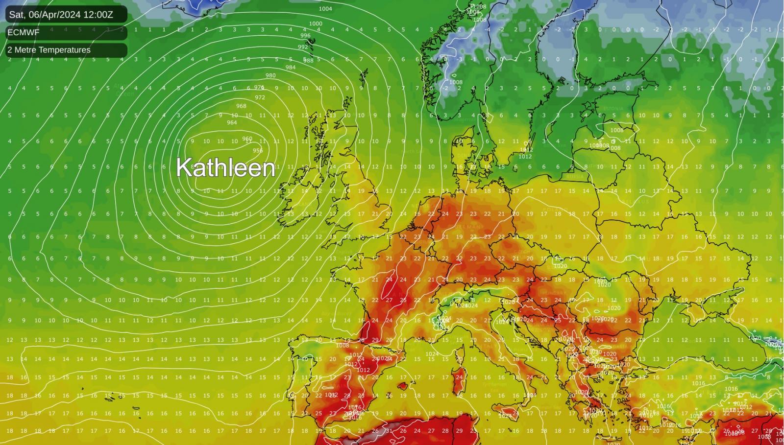
But the most exceptional temperatures will be found in France today. South-western France is forecast to reach around 30C, while a large part of central and eastern France, including Paris, is expected to see maximum temperatures of 25 to 28C. Southern Germany will also be unusually warm for the time of year, with some places reaching around 25C. This follows a general trend in recent years of France being especially susceptible to plumes of warm/hot air from northern Africa, which has been associated with numerous summer heatwaves with temperatures widely exceeding 40C. With it only being early April, today's temperatures will not be that excessive.
Sunday will remain windy, and there will be some showers and longer outbreaks of rain, again, particularly through Wales and southern and western England, and some of these will be heavy. There will, however, also be some sunshine for most, and many parts of East Anglia, south-east England and eastern Scotland will have a predominantly dry and sunny day. A mix of sunshine and blustery showers will continue to affect Northern Ireland and the western half of Scotland. Temperatures will be down on today's, and for Scotland, Wales, Northern Ireland and western England, they will generally reach between 11 and 13C. However, it will remain on the warm side for eastern England, and in East Anglia, many places will reach 17 or 18C.
It will again be more unusually warm in continental Europe. Sunday's warmth is forecast to be especially concentrated over central Europe, with southern and eastern Germany and Czechia seeing maximum temperatures in the mid to high 20s Celsius. Parts of eastern France may also reach around 25C, although in France, it will generally be cooler than today.