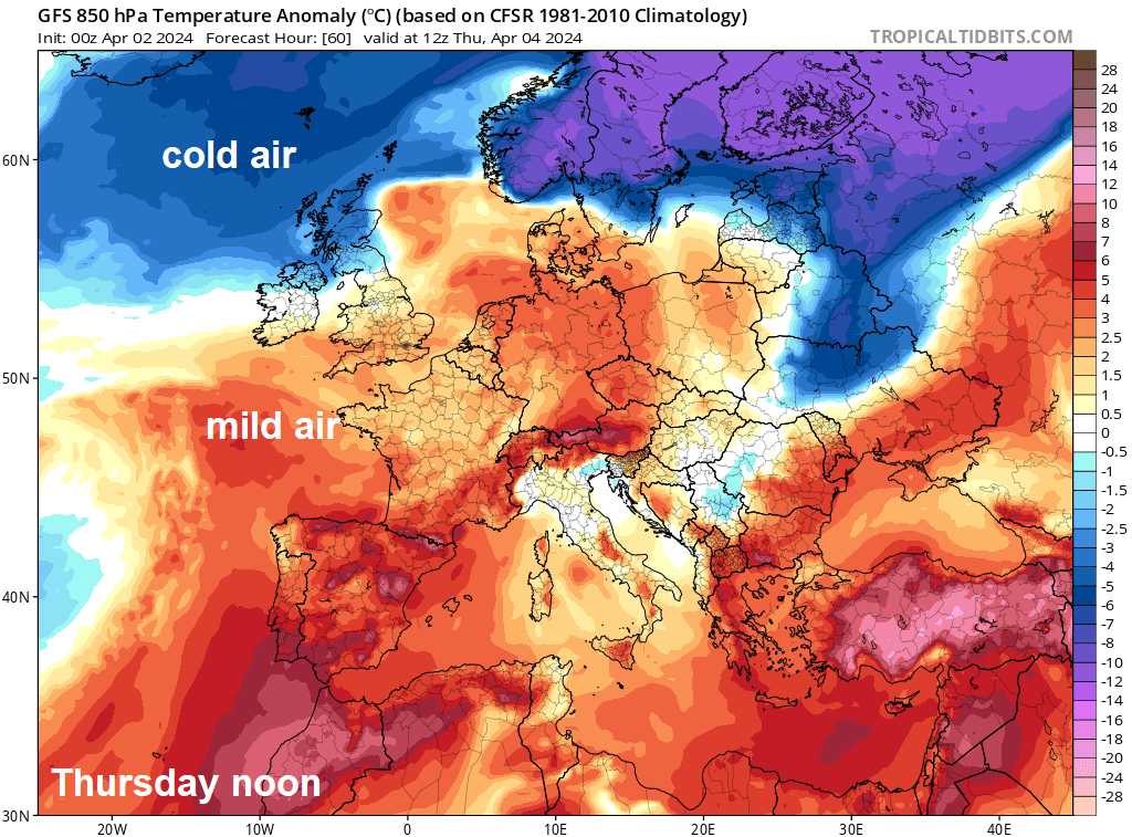
Low pressure will remain in the driving seat for the rest of this week, bringing further spells of rain or showers, increasingly windy later in the week too. Scotland will be in colder air, which will mean snow over the hills at times, rather mild for England and Wales.
Low pressure will dominate our weather for the rest of this week and through the weekend too. So, unfortunately that means more rain or showers will affect all parts, though there will be some drier and sunnier spells, especially in the south. There will be a north – south contrast in temperatures through much of the week too, Scotland will be on the chilly side thanks to a persistent northeasterly wind to the north of areas of low pressure moving northeast across Britain. Temperatures struggling to get out of high single figures, with snow falling over Scottish mountains in the north as areas of rain move up from the south and bump into the cold air streaming in from the northeast. While southwesterly winds across England and Wales bring much milder air, with temperatures reaching the mid-teens Celsius.
Easter Monday and the first day of April brought classic April showers and sunny spells across many areas, more especially England and Wales. Much of eastern England managed to stay dry and sunny though, allowing the temperature to reach 16.3C at Cambridge. Scotland saw a cloudier day with outbreaks of rain pushing up from the south.
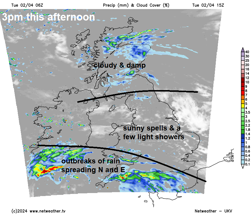
The occluded weather front bringing yesterday’s grey skies and rain to Scotland will linger through today, unfortunately, bringing another mainly grey day with patchy rain here. Further south across England, Wales and N. Ireland, a grey, misty or foggy start in places, some starting sunny, a few showers towards eastern England, but generally dry. Sunny spells should become more widespread through the morning, but the sun’s warmth will trigger scattered showers late morning and into the afternoon, though not as heavy generally as yesterday. Sunny spells and showers will be replaced by thicker cloud, outbreaks of rain and strengthening winds this afternoon across SW England and south Wales. Rain across the southwest then spreading north and northeast across England and Wales through this evening. Temperatures reaching 11-15C in the sunnier parts of England, Wales and N. Ireland, 8-10C across Scotland where it stays rather grey and damp.
An area of low pressure will move NE up through the Irish Sea tonight, wet and windy weather spreading north and northeast ahead of it across England, Wales, N. Ireland and eventually southern Scotland, before turning drier across southern areas in the early hours. Cloud, rain and hill snow affecting northern and eastern Scotland blown in by a strong northeasterly wind.
A mild but mostly grey start across southern Britain with a southwesterly breeze blowing in well-scattered showers, sunny spells eventually developing with showers tending to fade into the afternoon, with many becoming dry for a time. Outbreaks of rain across northern England and N. Ireland northwards for much of Wednesday, persistent across southern and eastern Scotland, more showery across northern England and N. Ireland. Far north and west of Scotland may stay mostly dry and bright with just the odd shower. A contrast in temperatures from north to south, chilly across Scotland in the strong northeasterly wind here, reaching just 7-9C at best, reaching 12-15C further south across England and Wales, in the mild southwesterly wind.
Heavy showers or longer spells of rain spreading northeast across much of England and Wales Wednesday evening and night with a new area of low pressure, clearing east Thursday morning to lighter more scattered showers and perhaps some sunny spells. Then more persistent rain arriving across the southwest in the afternoon before spreading northeast across much of England, Wales and N. Ireland in the evening, rain heavy in the west and winds strengthening too. Scotland mostly dry and bright or sunny during the day, though some showers in the northeast, before rain and hill snow arrives in the south in the evening.
Potential for a fair bit of snow across higher ground of Scotland Thursday night into Friday morning, as heavy rain spreads up from the south and bumps into the cold northeastely flow in place here. Snow tending to recede to higher levels through Friday, but potentially quite a wet day on Friday and feeling miserable in the cold northeast wind. Further south, a strong southwesterly wind will bring a rather mild day in contrast, showers in the west drier in the east.
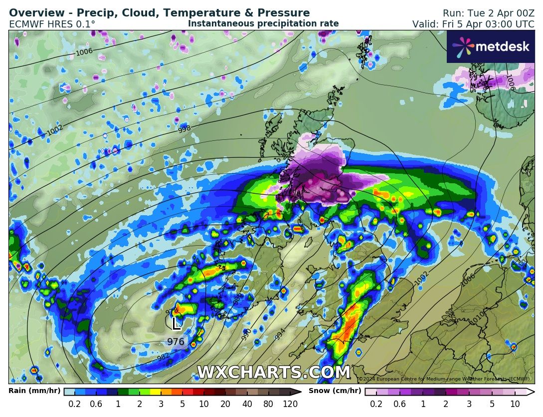 Chart from wxcharts.com
More heavy rain spreading north across many areas Friday night and becoming very windy too, especially in the west, as a deep low moves north to the west of Ireland, perhaps south to southeasterly gales developing up through the Irish Sea and over western coast and hills. Saturday looking windy with showers in the north and west, perhaps persistent rain and hill snow in the far north of Scotland, drier and sunnier for southern and eastern England – where it will feel warm in the sun, perhaps reaching 17C. Sunday is looking similar, a windy day with showers in the north and west, drier and brighter in the south and east, though temperatures perhaps a touch down on Saturday.
Top photo taken on the Isle of Skye by Malcolm Lightbody