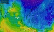
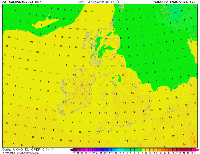
High pressure over Scandinavia at the moment has extended far enough west to hold back rain bearing fronts to the southwest of the UK over the last few days, but the brief drier spell is ending over the weekend, as low pressure over the Atlantic gets the upper hand. The weather then looks to remain changeable throughout next week too, with spells of rain moving through most areas, but also some drier and sunnier weather. But with the wind changing direction from a cool to chilly easterly to milder south or southwesterly through the week, it looks to turn milder for all. We could see temperatures reach the mid-teens later in the new week, more especially towards eastern England in any sunshine.
However, in reality, the weather may tease us with early hints of spring warmth, but the weather can flip to bring a cruel reminder of winter in early spring – even well into April. History tells us, there is always the possibility through March and indeed April, of a return of wintry conditions. Though, of course, often winter doesn’t return again until later in the year.
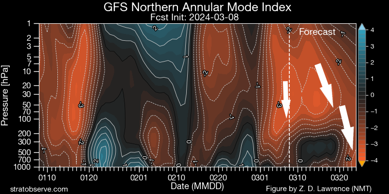
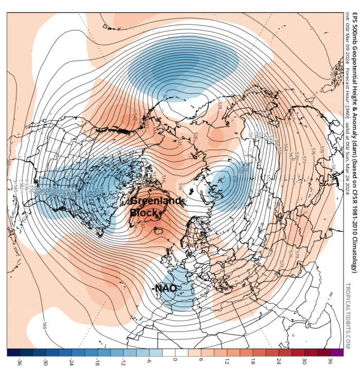
There’s no such flip back to winter showing in the models for the next 7 days at least. Though for the rest of March, we are keeping an eye on the potential impact of the Sudden Stratospheric Warming, that occurred last Monday, on the troposphere, the lower part of the atmosphere where our weather happens. There is uncertainty, at the moment, how much impact the SSW will have. There are currently signs that the reversal of winds high up in the stratosphere will reach the lower stratosphere over the coming few weeks and this may ‘drip’ down into the top of the troposphere, potentially encouraging high latitude blocking which can in turn lead to cold arctic air being pushed into lower latitudes of Europe and North America.
Reversal of winds in the stratosphere could 'drip' down into the troposphere (below 150 hPa) and induce HLB later this month ...
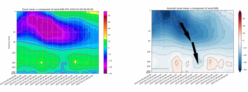
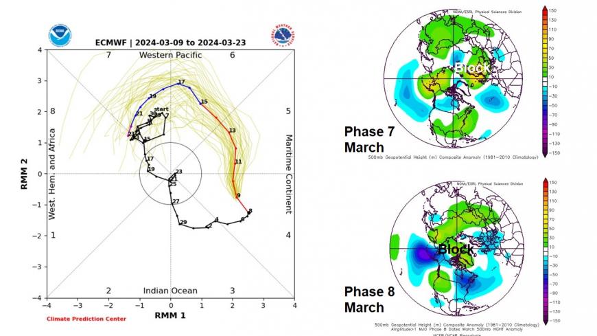
A substantial proportion of the model ensembles and the ensemble mean in the extended range have been signalling high latitude blocking around Greenland and Iceland later in the month. The high resolution runs will not pick it up for now, but may quickly flip to show high latitude blocking if the reversal working down the stratosphere drips into the troposphere. But what may be pointing the models towards high latitude blocking could be the Madden Julian Oscillation moving across the Pacific Ocean encouraging high latitude blocking too. It could be the MJO driving the signal for high latitude blocking over the SSW, as for now there is no concrete signs that the SSW reversal will propagate down into the troposphere.
00z EPS 500 hPa mean for Sun 24 March
MJO moving through phases 7 and 8 on the plot (left) may induce HLB later this month into early April (taking in ~10 day lag from each phase)
Articles have begun to appear in the media about the most recent SSW being a ‘rare’ once-in-a-250 year event ‘that could bring some very cold temperatures with it.’ It is the 3rd SSW attempt this year in as many months,
But although these articles refer to the Met Office blog mentioning it’s a rare SSW event, there are experts in the field of the stratosphere that state otherwise. Amy H Butler and Simon Lee in their tweets below, would not consider this a "3 SSW" winter because the ~14 days between this and the Feb event is simply not enough to make the two events ‘dynamically separable’.
But, this third attempt at the beginning of the week does look to have a greater chance of bringing a reversal of winds down towards the troposphere, as the reversal is forecast to be more sustained, so perhaps changing weather patterns may induce high latitude blocking. But no certainty on this outcome yet and if HLB does occur, no certainty whether it will bring a flip back to winter weather later this month or into early April.
Looking through the records over the years, the return of snow and below freezing nights is not as uncommon in March or even April as you’d think. Below are some of the more notable flips from an early taste of spring back into winter in March or April:
2021 - April was very cold and dry with frequent northerly winds. There were an unusually large number of night-time frosts, with the mean minima well beneath average. May was also generally cold but also wet, nationally it was the coldest May since 1996.
2013 – March started dry with mild spring-like days but chilly nights, Trawsgoed, Ceredigon, west Wales reached 17.5C on the 5th. However, from around the 10th, a very cold easterly flow developed sourced from Siberia. Heavy snow fell on the 11th and 12th on the south coast and even Channel Islands, further snow brought disruption to NE England and eastern Scotland mid-month. Between 22nd-24th saw the most significant snowfall, as Atlantic frontal systems bumped into the cold easterly flow, bringing prolonged and heavy snow to north Wales, northern England, SW Scotland and N, Ireland – with 20cm falling widely. Bitter easterly winds continued for the rest of the month. Snow fell on 20 days across parts of the Midlands, northern England and Scotland from the 10th.
2001 – March saw spring arrive in fits and starts. A very cold and snowy start to the month, some low sub-zero maxima in the north, -4.6C at Cassley, Sutherland on the 2nd, then the following morning -21C at Altnaharra on the 3rd. It then warmed up, with 17C at Cardiff on the 7th, mild spell lasting until mid-month, but just when it seemed like winter was left behind, cold returned from mid-month, as a bitterly cold easterly flow developed. 10cm of snow fell in Powys on the 17th, also significant snow in the south on the 20th, as Atlantic fronts bumped into the cold air.
1989 – After a warm end to March, with Canterbury reaching 20.7C on the 28th, an area of high pressure developed over Scandinavia from April 1st, which ushered in unusually cold air from the east for a few days, with London seeing snow on the 5th, 18cm of snow at Tadworth (Surrey) on the southern edge of London. There was a SSW that led to a split polar vortec late in February.
1981 – After a wet but mild March, the first half of April was sunny and warm, particularly in the north, Easter was cloudless, but soon after northerly winds set in, sweeping cold arctic air south on the 22nd. There was a maximum of only 1C on the 24th at Leeming (Yorks) and Nottingham. Significant snow fell across the Pennines, Midlands, West Country, central southern and SW England between the 24th and 26th, blizzard conditions across the Pennines with 20’ drifts across the Peak District.
1975 – March you’d expect temperatures to get progressively higher as the month wears on, but not so this year. Highs of 14-15C were recorded in England and Wales during the first week. But, by contrast, the Easter Holiday (28-31) was cold, with showers of snow, sleet or hail. There was snow cover in places during the holiday. Cold northerlies with snow showers continued during the first 10 days of April too, with lying snow in the southeast on the 9th.
1968 – A late March heatwave saw the temperature reach 25.0C at Cromer, Norfolk on the 29th, thanks to southerly winds. However, 4 days later, it was snowing in London and parts of SE England, after a cold front moved south on the 2nd of April, with a low of -10.6C recorded at Achnagiochan (Strathspey) that morning.
Of course, there are mild spring-like ends to winter, that lead into warm springs, with no return of winter, that get progressively warmer day-by-day. 2003 was a good example of this. February was mild, March and April were dry, sunny and warm on the whole – this then lead into a hot summer.
Loading recent activity...