A blustery sometimes unsettled weekend. There will be fair, even brighter spells but this is not reliable weather, a shower could appear.
There is still time to post a card, first class, today. If you are planning a Mother’s Day visit, the weather isn’t looking great, rather unsettled. A few parts of the UK could be lucky and see brighter skies but not for the whole day as showers and bands of rain move around.
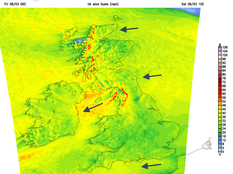
The overall pattern for the weekend has stayed the same. We have high pressure over Scandinavia and a low pressure heading to the Bay of Biscay which will drift over France by the end of the weekend. There is plenty of fair weather around for Friday evening although with a cool easterly wind and blustery lee gusts for western Britain. That wind will still be around on Saturday morning for Western Scotland and counties around the Irish Sea.
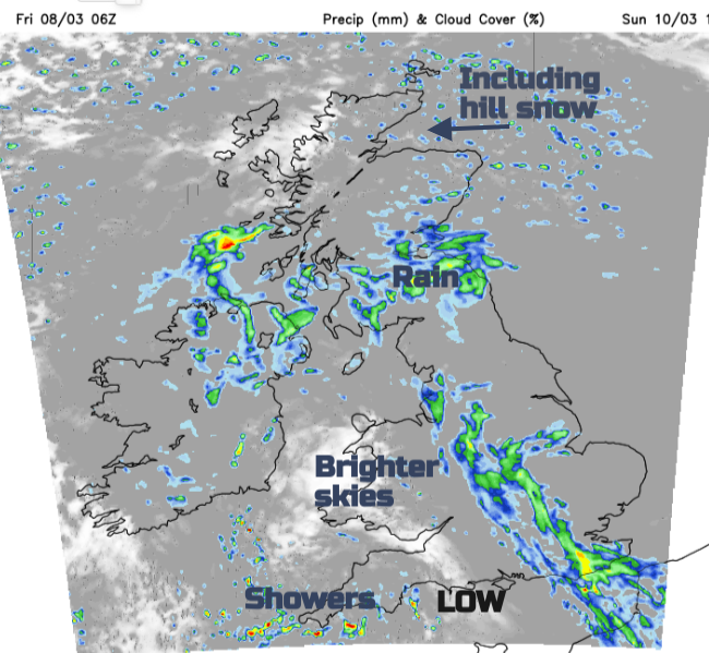
The low pressure will throw showers and bands of rain up towards the UK during the weekend. One frontal band will be reaching over SW Britain by Saturday morning reaching into south Wales, and Cardiff along the M4 and M3, so there is a bit more of an unsettled picture for some southern counties of England for early risers. The showery rain looks to soon drift over Wales, brushing the Midlands This gradually edges over the Irish Sea to Northern Ireland on Saturday morning and also dampens northern England. Meanwhile, the onshore flow off the North Sea will bring outbreaks of light rain, even wintriness over the high ground of NE Britain. Cold air continues to affect northern Scotland throughout the weekend. Later in the afternoon, there will be thicker cloud and a few outbreaks of rain for NROhtern Irelaln and much of Scotland. The far northwest and the islands look bright with sunny spells. There will be a scattering of showers, with some heavy ones, from the low pressure which will affect SW Britain. For the central parts, there will be a mixture of fair weather with bright spells but still feeling cool in the wind.
Saturday night
The precipitation gets going overnight with clusters of showers spinning up from the southeast over England and Wales. The wintry outbreaks, or just icy rain, pep up a bit over eastern Scotland too.
The forecast isn’t looking great for Sunday morning. The winds will have dropped for southern England but the easterly continues to make its presence felt further north. It will feel chilly for Scotland away from sheltered areas and along the North Sea coast of England.
Getting the details of any rain or showers at this point, maybe for a walk on Sunday morning, is tricky. Don’t rely on a timeslot from a weather app to guarantee a dry, or sunny outing. Bands of rain and clusters of showers continue to reach up from the low to the south. Daytime temperatures will vary from 7 to 12 CElsius with a few brighter sheltered spots perhaps reaching 14 or 15C this weekend. By night temperatures are dipping down to 4 or 5C with occasional clearer areas falling to zero. So take care of any plants that are gifts ready and waiting.
There are still high groundwater and high river levels in parts of England and with equinox spring tides coming up over the next few days, the Environment Agency is making plans to operate the Thames Barrier, starting at the weekend. These are some of the highest tides of the flood season.
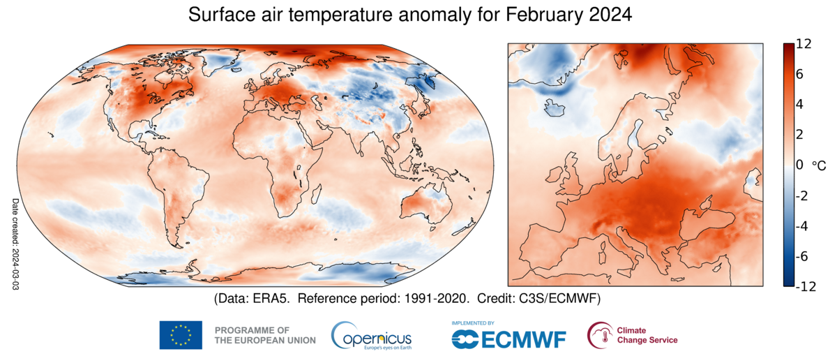
It has been the warmest February on record for the world as Global Sea Surface Temperatures hit record highs. Copernicus ECMWF. This is the ninth month in a row that was the warmest on record globally, for the respective month of the year. England and Wales saw their warmest February on record with the main driver of such warmth being human-induced climate change.
As we think about the generation before us on Sunday and generations to come, sobering words from Carlo Buentempo, Director of the Copernicus Climate Change Service (C3S):
"February joins the long streak of records of the last few months. As remarkable as this might appear, it is not really surprising as the continuous warming of the climate system inevitably leads to new temperature extremes. The climate responds to the actual concentrations of greenhouse gases in the atmosphere so, unless we manage to stabilise those, we will inevitably face new global temperature records and their consequences.”