Out of the breeze this weekend, it will feel okay in the south but cold air remains in the north, especially chilly in the east wind. Six Nations weather too.
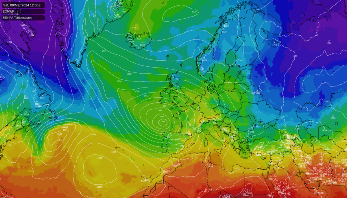
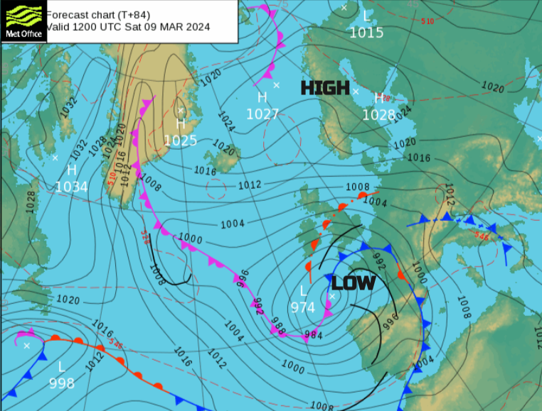
By the end of this week, there will be high pressure over Scandinavia steadying the weather down in the north and an Atlantic low pressure which will park itself in the Bay of Biscay and throw unsettled weather our way.
It’s like a calm stable adult to the northeast and a toddler whirling about to the southwest causing a disturbance. It's throwing out bands of rain that occasionally reach the UK during the weekend. There is uncertainty of where and when the rainbands will be on Sunday. Iberia, France, the western Mediterranean and even northwest Africa will see rain from this low, even heavy downpours in parts. There are flood, wind and mountain snow warnings out already, for Friday for mainland western Europe and rain in the forecast for Rome on Saturday as Scotland play Italy in the Six Nation's rugby.
In between the high and the low will be an overall southeasterly flow but often with easterly surface winds. This will bring cloud and showery outbreaks of rain off the North Sea for the weekend. with a rash of showers over northeast Britain by Sunday. In the far North, a feed of colder air remains originating more from Denmark and the southern Baltic.
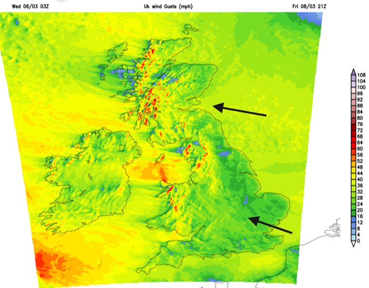
The details in this weekend's setup will be tricky. Temperatures will be around average for most, so 9 to 12C, although sunny sheltered spots could go higher. On Friday western Britain will experience strong lee gusts and it will become dry to end the working week.
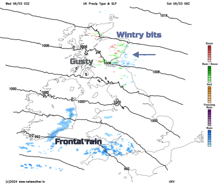
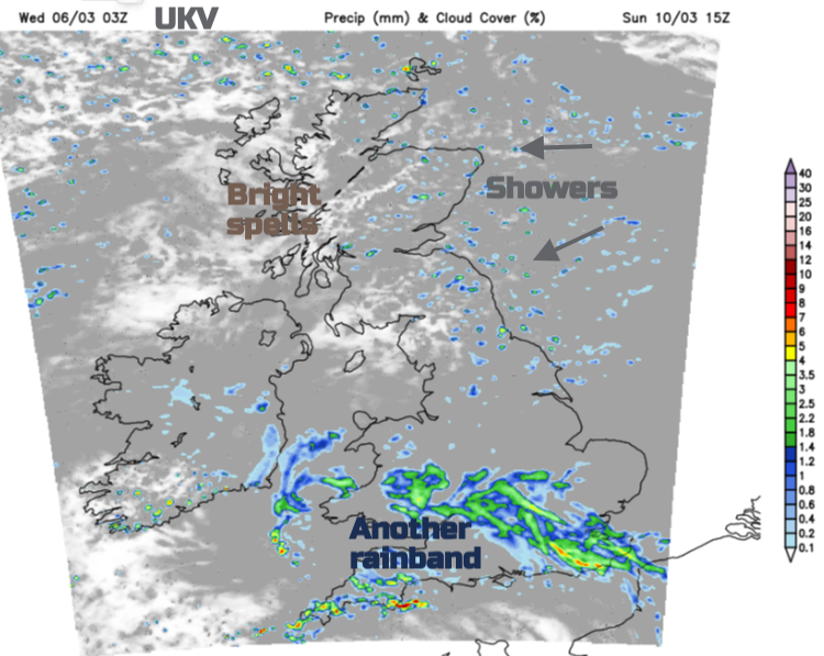
The easterly flow keeps colder air over northern Britain into Friday evening and there could be some wintriness over the Grampians, from the thicker cloud.
Saturday
By Saturday morning there will be a touch of frost for sheltered inland spots in northern Britain. The easterly wind continues with significant lee gusts for Gwynedd, Cumbria and west coast Scotland so do be aware if you are out hill walking. It will feel cool along North Sea coasts in that wind. The first band of rain from the toddler low will be over Cornwall and Devon by daybreak. The UKV model doesn’t make much of the rain in the southwest on Saturday, it fades by lunchtime over southern Wales with just a few lingering showers.
Southern Britain will see temperatures lift in air originating further south from central Europe and coming up around the low pressure. Here should be widely into double figures as the wind eases. For England v. Ireland in the Six Nations late on Saturday afternoon, Twickenham should be dry, not too cold but with a bit of a blustery wind to consider.
Saturday night
Another showery band appears from the south later on Sunday as the damp and icy flow continues for northeastern Scotland. In between it stays dry but there is some uncertainty about how far north a waving occlusion will push rain.
For London and the Home Counties, temperatures will reach 10 to 13C over the weekend but will feel cooler in the blustery breeze on Saturday. Saturday looks mostly dry but with a good deal of cloud. Rain should arrive from the south for Saturday night and could wave back over SE England on Sunday. Keep an eye on that bit of the forecast if you have outdoor plans. Glasgow should see a dry weekend, maybe with some brightness on Sunday but it will feel cool. Temperatures will show 8C but the wind will make it feel chilly and the cloud cover could be gloomy. Newcastle will have a quiet weekend weather-wise with a good deal of cloud, maybe the odd shower on Sunday but air temperatures of 7C will feel much lower in the easterly wind. Belfast will be blustery at 8C but feeling cooler. There is some uncertainty around how far the rainband will reach, so keep an eye on the forecast. Cardiff will see some rain this weekend but there will be good dry spells in between. For Wales v. France on Sunday afternoon at Principality Stadium there could be outbreaks of rain with accompanying blustery winds but low confidence at the moment. Temperatures should reach 10C but it will feel cooler in the wind on Saturday. Turning nippy for Sunday night.
Sunday
Southern Britain, the Irish Sea and Wales look likely to see outbreaks of rain. It will be rather patchy and the showery flow off the North Sea continues. Colder air holds on for Scotland and NE England into Sunday. This means the showers will be a mix of snow for the mountain tops but mostly rain sometimes sleet in the flow. Again it will be gusty to the lee of the Pennines and Cumbrian Fells in the east to northeast wind. The winds will be lighter for Northern Ireland, western Scotland and southern England.
There will be brighter breaks, even a bit of sunshine for northwestern parts of the UK, even eastern England. The ECM model pushes the rainband into Northern Ireland on Sunday and up into northern England. Other models merge it with the onshore flow bringing more rain to NE England and SE Scotland. Uncertainty around the rain on Sunday and if the main band does surge northwards there will be heavier showers breaking out over southern England.
Next week starts with drier weather as the flow veers to a southerly.