February was mild and wet, particularly for southern Britain and the ground is sodden. There are signs of a drier March, perhaps colder later on. This week will see drier days.
Overall the week ahead looks drier, after an initial bout of rain from the southwest on Monday. There will be a bit of frost and fog this week but daytime temperatures will be around 8 to 12C. We have stepped into meteorological spring but there has been a huge amount of rain in recent months and the ground is soggy. When yet another lively rainband passes by, you might wonder which paths will be flooded, or prepare yourself for vehicle routes where you have to navigate large puddles or muddy potholes.
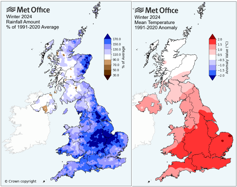 The Winter and February 2024 climate figures are out from the UK Met Office. They show a very wet winter away from the northwest, with eastern Scotland and much of England being particularly wet. It has been warm for all but northern Scotland. And yet if you change to the previous decade’s data, for comparison in our warming world, everywhere had a mild winter.
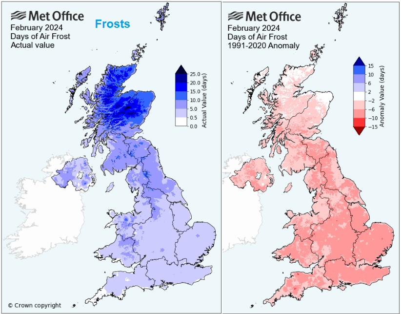 There were days with an air frost but not many, thinking back to how February can be. England and Wales both had their warmest February on record (provisionally) with most of the UK seeing a mild February. "The UK experienced its second warmest February, averaging 6.3°C" Met Office
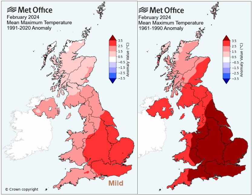 Only the extreme north of Scotland saw an average February, temperature-wise.
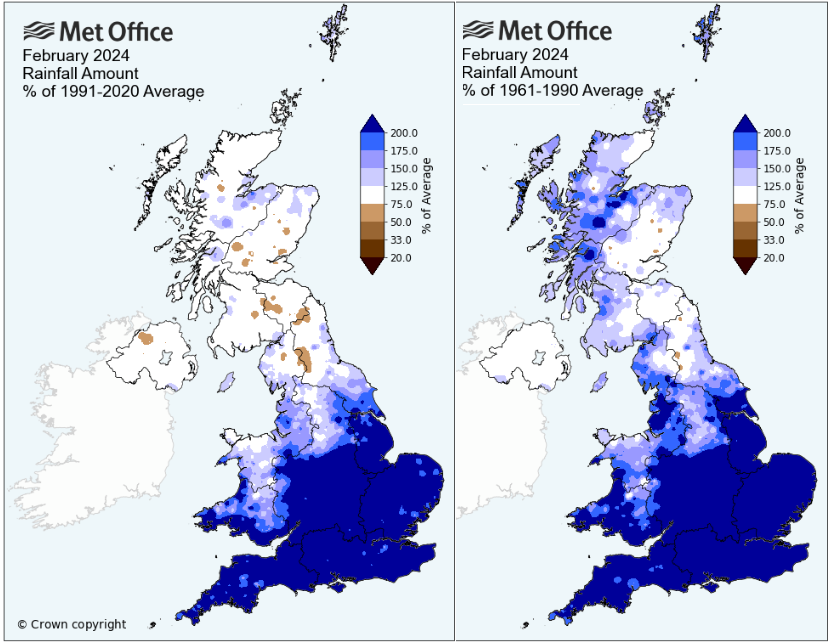
The rainfall data for February shows a more dramatic divide with southern Britain drenched. Northern Ireland had an average month for rainfall as did the high ground of Wales and northern England, also a good deal of Scotland. These areas would climatically expect a good deal of precipitation in the winter month, but the mountains have often seen rain rather than snow.
Synoptically it’s been quite slow over the UK this weekend with the same low pressure drifting about. It’s heading to Iceland today. There is a high pressure building over Scandinavia and that will be quite a dominant force for our weather this week. It acts as a shield for incoming Atlantic low pressures, weakening their arrivals. The frontal bands fade to cloud with patchy or showery outbreaks rather than the vicious heavy bands we have seen. The flow comes from the south or southeast at the surface. Way up high in our atmosphere
“A major sudden stratospheric warming will occur (tomorrow), Monday 4 March, as defined by a reversal of the daily-mean 10 hPa 60°N zonal-mean zonal winds to easterlies” Dr Simon Lee
While waiting for any effects to reach the surface, there are signs that high pressure will remain in the northern quadrant to the UK allowing drier conditions this month. A more southerly flow keeps things milder but if that does shift to the east, it will feel colder later this month. This is just one driver, Nick Finnis looked at the wider picture last week.
 This week
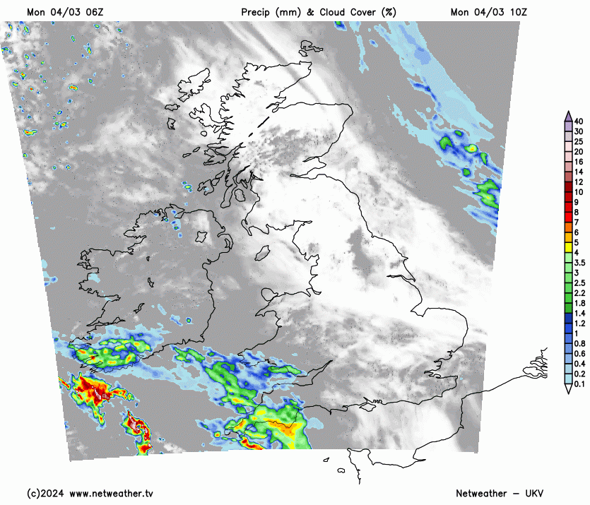
The frontal cloud that scuppered eastern Britain’s view of the aurora last night has now decided to wave away over the North Sea but will edge back to NE Scotland midweek. The rain over Cornwall for the start of Monday is linked to a little low pressure near SW Ireland and the front will push northeastwards today over SW Britain, and slowly more of Wales. There will be a fresh southeasterly wind, with strong gusts which will veer to the west after the front. It should reach the Isle of Wight by teatime with some heavier bursts then edging over the Irish Sea into Northern Ireland and extending down to Brighton by this evening. This patchy rain band continues over eastern and then northern Britain tonight.
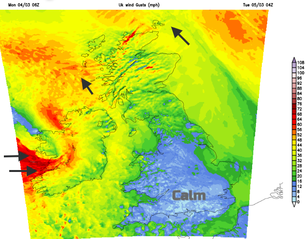
This links back to showers in the English Channel by Tuesday morning and the wrap round occlusion will bring some heavier bursts up through Northern Ireland. It will be windy around the low centre but calm for much of England and Wales. It’s not a completely dry picture but many parts of the UK will have a fine, bright day and then a quieter Tuesday night.