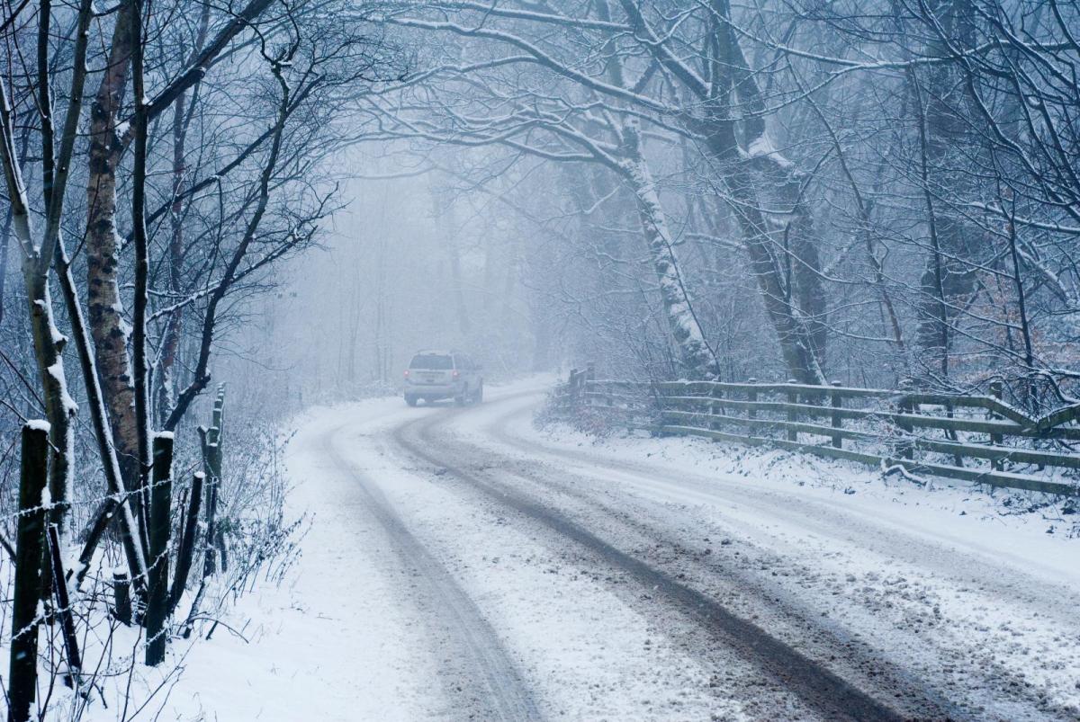
Parts of Cumbria saw over 30cms of snow on Sat. 2nd December, that's a foot of snow. There was disruption, power cuts and people stuck in their cars, so how to prepare.
There has been a taste of winter for the UK during the end of November and the start of December. Cold Arctic air, frost and ice with snow in some areas. Shap, Cumbria saw an overnight low of -9.4C early Friday and for Highland Scotland this weekend, Aviemore -11C early Saturday and Altnaharra -12C by Sunday. There will be a change this week, back to milder, wet and windy weather from the Atlantic but Cumbria is still recovering from the weekend’s snow event. A foot of snow fell in places with widespread disruption and impacts for southern and western parts of the county. Roads became impassable with a large number of vehicles and passengers becoming stranded. We are not expecting to see any more significant snow, certainly not like what happened on Saturday. There is wet and windy weather over some parts of the UK on Monday with snow for the very tops of hills in northern England, Snowdonia and a more wintry mix in the showers over brighter Scotland.
“CFRS Cumbria Fire & Rescue Service has been working through the night rescuing people from their cars trapped in deep snow. Please do not travel unless necessary as many roads are still affected with snow and ice.” Sunday 3rd 0836
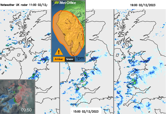
The change in focus from east coast to west coast Britain had been forecast, with snow showers expected off the Irish Sea but not to this extreme. The UK Met. Office warning system includes forecast likelihood and expected impact levels. The UK had been littered with yellow Snow & Ice warnings highlighting the overall wintry, cold picture. For those making weekend plans on Friday or even heading out on Saturday morning, there was nothing out for the southern end of the Lake District and a rather light touch “Wintry Showers, snow & ice” yellow warning for Cumbria into SE Scotland. The amber warning came at 1pm by which time some areas already had several cms of snow.
The warnings need to be timely, to help people make informed good decisions. December weekends are often planned well ahead (except maybe the two days before Christmas when people are panic buying). There are Christmas party nights, shopping and markets, visiting relatives or sporting events. The Met Office will repeat that all warnings; yellow, amber and red are about severe weather and that the Matrix part and text give extra important information. And yet there is a perception problem, especially when there have already been several days of severe weather and warnings. That another yellow warning just begins to blur into the background, whereas an Amber warning will make people pay attention, hopefully. And how many do seek out the matrix? It needs to be more accessible.
 Cumbria Police “The focus of a response to a major incident following the impact of heavy snowfall has moved to supporting communities who remain without power.” 800 remain without power by Monday lunchtime according to an Electricity NW update.
Sometimes you do have to be almost on top of a weather event to firm up the detail. ‘Nowcasting’ off the radar. This was a setup similar to Lake Effect snow, with a feed of precipitation streaming off the Irish Sea. There was cold Arctic air over not-as-cold waters enabling instability, with a bit of convergence. Convection, generating clusters of showers with some lightning recorded over the Sea before the showers were steered east/northeast to the Lake District. There was a signal for this setup but not for the large deposits seen near Ambleside and Coniston, nor the falling snow’s persistence on Saturday. Other regions saw snow falling as showers pushed further inland across the North Midlands, mid-Wales, North Yorkshire, the Pennines and Peak District. It was quite the wintry scene across a central swathe of Britain.

We need to look at the wider weather picture when travelling and not just a weather app symbols for one location. That could be listening or watching a weather broadcast, checking the radar, to see what is happening and moving our way. Also reading the extra text and following winter driving advice. The warnings shift this week from Snow & Ice to heavy rain and flooding, enhanced with snow melt adding to the river flow.
If your car has taken 20 minutes to defrost and de-ice then you might be tempted to drive too fast for the conditions to make up that time. Give yourself enough time in the first place in winter and take it easy out there. Anyone who passed the numerous cars in fields or even upside down off the A1 this week would know the results of just a small bit of ice in the wrong place.
Dress with the possibility that you might have to get out. A big coat, decent shoes and a hat just in case. Have enough fuel and a charged mobile phone, even some water and a snack. Have a de-icer and ice scraper in your car and make sure your windscreen fluid is topped up and suitable for the lower temperatures at this time of year, it will outline the range on the bottle. Check your tyre tread and pressure. Also, your windscreen blades are in good condition and your car lights all work and are clean
AA Advice Driving on winter roads. "Pull away in second gear, easing your foot off the clutch gently to avoid wheel-spin. If you have to use your brakes, apply them gently.
If you get stuck in snow or ice, straighten the steering and clear the snow from the wheels. Put a sack or old rug in front of the driving wheels to give the tyres some grip."
A blanket on the back seat could just stay there over the next few months and the RAC recommend a torch (not just the one on your phone).
RAC Advice - “if you are embarking on a long journey with snow forecast then be sure to pack extra waterproof, some sturdy footwear, a shovel, a warm drink in a flask and a fully charged mobile phone.”
 For those who managed to get out sledging at the weekend, hoorah for you. For those who were stuck in cars or vans for hours hopefully, it is now just a tale to tell and there are no lingering ill effects. I’d imagine everyone will be glad to see the back of the ice though as the milder air arrives. That has been a nightmare.
How is the winter forecast shaping up, when might the snow return? A technical in-depth look at the next few months.
NW England community forum group.