Cold air will be around into the start of December and there will be snow showers off the North Sea for Scotland and the hills of northern/eastern England. Elsewhere, uncertainty.
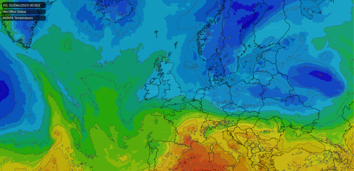
After plenty of mild and wet weather this autumn, the transition to winter has begun. We have colder Arctic air taking a firmer hold this week and lasting into early December. There will be a flow of rain, sleet and snow showers into northeastern areas with additional snow for the covering that has begun on the Scottish mountains.
Elsewhere around the UK, we would expect bright sunshine, frost, and perhaps some morning mist and fog. It will feel cold and when the wind picks up the windchill will be noticeable. It’s time for the winter wardrobe, gloves and hats and checks on vehicles so that they are ready for icy conditions.
 There has been talk of the possibility of snow for southern Britain. I see one news outlet chose “UK cold weather: Scandinavian snow bomb to bring sub-zero chill for ENTIRE WEEK” as a headline. A bit strange as the possibility was linked to a low pressure from the south. The Guardian was more measured and helpful with “Cold weather expected to continue in UK with ‘potential snow event’”
High pressure builds over Greenland this week and the “potential” was from a low pressure moving from the Azores, over the Bay of Biscay and then sliding over northern France. A bit further north (as the models had seemed more keen on at the weekend) and the precipitation would have butted up against the cold Arctic air, bringing the possibility of snow. There is still low confidence about the track of this low pressure and whether the precipitation on its northern flank will impact southern Britain or not. If it does, will it produce snow and then, will it settle and where?
The ongoing cold spell is linked to wider areas of high pressure up in the Arctic circle to the north of the UK, “ a period of extensive high-latitude blocking”. These large lumbering anticyclones don’t shift much and as they settle over cold land masses in winter they block the usual progress of Atlantic low pressures. A high over Scandinavia (a Scandi-High) can result in a viciously cold flow of air from Siberia reaching NW Europe as an easterly wind sets in around the base of the High pressure. The ‘Beast from the East’ set up in 2018 saw a Polar continental air mass reach the UK and heavy snowfall resulted. The highly dramatic Channel 5 rerun on Sunday night of “Beast from the East - The Big Freeze of 2018” incorrectly said that journalists had created the phrase in 2018 but it is a long-established informal name for a particular meteorological winter setup, that doesn’t occur that often.
We have a Greenland high and this results in northerly or northeasterly winds reaching the UK with an Arctic maritime air mass.
 If we were in January or February, we would be talking about bitter cold and a higher chance of proper snow with this high latitude blocking.
“However, the absence of significant cold spells this autumn means sea surface temperatures in the North Sea are relatively high for this time of year. Moreover, North Atlantic sea surface temperatures remain at record highs. Given these elevated global temperatures, the northern blocking and the northerly and north-easterly winds may struggle to bring much snow, particularly at lower elevations” Ian Simpson Sat 25th Nov
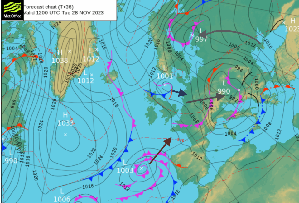
There are plenty of low pressures to watch this week. The Black Sea has been battered this weekend by Storm Bettina with violent huge waves, coastal flooding and power outages. Our weekend low pressure which was still bringing rain to Wales , England and the Benelux countries on Monday morning will march across central Europe reaching Ukraine by midweek. This helps direct the cold Arctic air down the North Sea in its wake. A rash of showers will continue on Monday, swarming off the North Sea, mostly as rain for eastern England but pushing well inland later today, with wet snow over the Pennines and windward side of the Peak District.
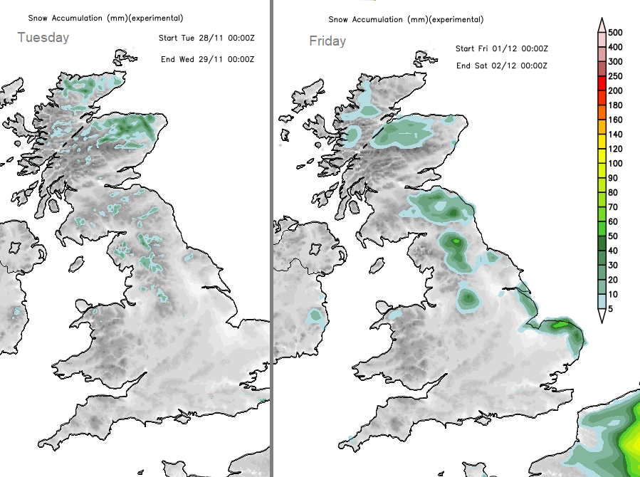
 Little low pressures begin to appear in the flow down the North Sea as the colder air digs in. Lines of wintry showers will move from the Northern Isles over northern mainland Scotland. More showers will reach eastern Scotland and NE England with a signal that a line of mostly rain showers could reach Northern Ireland, the Isle of Man and north Wales on Tuesday night. These will be of rain, sleet and snow with several cms for Scottish hills and mountains also reaching the Pennines, Cheviots and the North Yorkshire Moors.
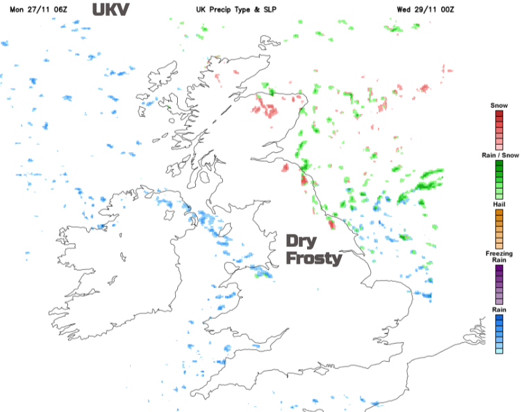
For most, the next few days will turn colder with light winds, frost and sunshine. The main focus for showers will be northern Scotland, and eastern Britain with icy rain at sea level and maybe a few snow flurries. Snow over the hills and a wintry mix in between. North Sea coasts will experience more of a breeze and that will add to the chill.
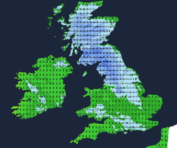
Further south, there could be freezing fog patches forming, which combined with frosty windscreens and the need to demist properly, means that journeys may take longer so do allow for extra time this week.
Later this week there could be heavier snow for Grampian, which might lead to impacts on roads in northeast Scotland and possibly the far north of mainland Scotland and more of eastern and central Scotland, say into Perth & Kinross. For the southern low, we will have to see how things develop. The ECM model keeps it further south over France on Thursday but signals a stream of showers, potentially wintry ones, even proper snow over Kent and Essex on Thursday night as the flow backs. It can be a bit too keen on producing snow over the UK. It will be an interesting week to watch, probably for most not a fruitful one if you looking for snow but more chat and discussion in the Netweather community forum. And there is a rumour that the Santa Shaker will be back this week.