More rain this weekend. Repairs and recovery from Storm Babet are still ongoing in parts of Britain with rain forecast later this week and coastal concerns. Flood issues will only increase.
October 2023 has been very wet. There are still 30 flood warnings (7am Thurs 26th Oct) in England, one near Tenby in Wales. These include remnants from last weekend along the River Trent and River Severn but also new coastal ones. Eastern Britain has seen huge amounts of rain and severe flooding, as did parts of the Midlands and Yorkshire in Storm Babet. Scotland has seen two episodes of heavy and persistent rain this month, with ongoing disruption in the east due to the amount of water and damage from the flooding. Any more rain will be viewed with concern.
There will also be windy weather with the potential for gales for certain parts of the UK. With spring tides at the weekend, combined with the high river levels, the risk of flooding remains, heightened by another spell of wet weather even though there won’t be the same torrents as from Babet.
For the last weekend of October, there will be low pressure covering the UK. There is already one Atlantic low lurking out west. Hefty showers will rotate around this one across the UK and Ireland on Thursday although with large fine gaps inland. By Friday morning there will be more organised bands which will become focused over northern Britain and the Irish Sea by Friday lunchtime with a cool easterly wind.

Areas of concern for Friday 27th highlighted in the Flood forecasts from Env. Agencies.
An occluded front from the Atlantic low will push more rain towards SW Britain for Friday evening with brisk southwesterly winds and more heavy showers will follow for Saturday. However, our eyes must move west, back out into the mid-Atlantic at a new developing system. This deepening low pressure looks to nip from the Bay of Biscay to the English Channel and bring heavy rain (and strong winds) our way for Saturday night, Sunday and Monday.
"Local flooding is probable from coastal/tidal in the south and west of Wales on Saturday and Sunday. Further flooding is possible but not expected from rivers and surface water across parts the south of Wales on Friday into Saturday and more widely across Wales later Saturday into Sunday. " Natural Resources Wales
The strongest winds will start early Saturday for the far north of Scotland in an easterly flow but continue into Sunday, backing slightly. Depending on how smaller low centres develop at the weekend there could be gales for Cornwall and Pembrokeshire, perhaps on Saturday afternoon or evening, extending into the Irish Sea or English Channel. There will be another bout of strong winds as another area of heavy rain heads to southern or southeastern England on Sunday.
The ensemble forecasts signal bands of heavy rain around the low centres. Rain moving up through Britain on Saturday night and rain for eastern or SE Scotland, maybe into NE England with another band through the Channel or over SE England by Sunday.

Clusters and bands of heavy showers on Thursday. "greatest risk of thunderstorms will be across southern and western coastal areas of England and Wales and across Ireland" Convective Forecast
If you are looking at a weather app for timings of when rain might affect you it is worth considering the uncertainty in the forecast as the weekend progresses. To start the weekend there will be showers off and on, affecting some spots and not others, although exposed areas of southwest Britain look likely to see some downpours. Saturday morning Parkruns will be wet enough underfoot again this week.
Brighton A blustery start to the weekend with fresh southwesterly winds, outbreaks of rain at times but then brighter spells. Temperatures start around 15C but dip away to only 13C on Sunday although the winds should ease off, after a potentially lively spell on Saturday night.
Scarborough There should be some respite on Saturday with lighter winds, still off the North Sea with grey skies but drier spells, 11C. Sunday will feel colder with a northeasterly wind and rain.
Abersoch A mixed weekend with a brisk southerly wind that eases on Sunday. In the southerly flow, there will be bands of rain but then drier, perhaps even brighter spells and temperatures up to 13C.
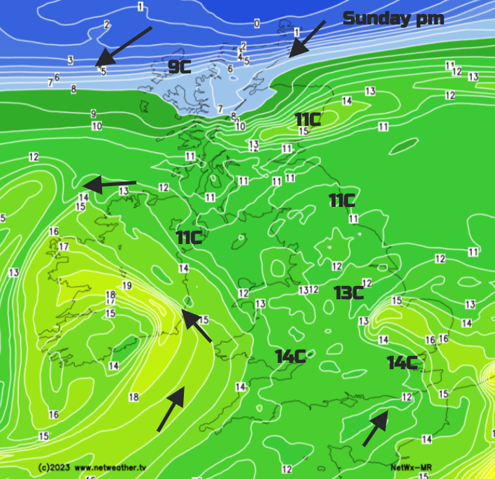
The rainfall totals look high around the Irish Sea for eastern Ireland and County Down. Also for southern counties of England and through the English Channel during the weekend. The GFS model has heavier rain over Kent and Sussex later on Friday. The main weekend rain will arrive from the southwest on Saturday morning and push north through Wales and England on Saturday night. There is uncertainty about where it settles in the north but another pulse of heavy rain looks to head in for Sunday afternoon over SE Britain.
"Local flooding is possible from coastal/tidal in South West England on Friday, extending to parts of South East England on Saturday, becoming probable in parts of South West and South East England on Saturday. Further flooding is possible but not expected from rivers and surface water across parts of the East Midlands and East of England on Thursday into Friday, parts of the south of England including London on Friday into Saturday and more widely across England later Saturday into Sunday." Env Agency for England
The Netwx MR model shows heavy rain from the SW later on Saturday with wet and windy weather heading up the Irish Sea. Over Wales, England into Northern Ireland and then settling over eastern Scotland early Sunday. There will be areas of rain for southern Britain in the southwesterly on Sunday.

The ECM model has one band of rain stuck over Scotland with rain for the worst of the flood-hit areas and heavy and persistent rain over SE Britain during Saturday night. This pulls over East Anglia early on Sunday but the easterly flow off the North Sea is a worry. How it will affect eastern and NE England and eastern Scotland driving rain onto the eastern counties with the high tides and the existing sensitive conditions?
There is already a yellow warning for rain over eastern Scotland due to these concerns. “Persistent and occasionally heavy rain may lead to some flooding and transport disruption in places.” MO
Along with the weather warnings, the Environment Agencies issue flood forecasts for a few days ahead. These use a combination of the Met Office precipitation modelling and the river, coast and ground condition modelling from the environment agencies. These do not falter...
“because most of our rain tends to come in from the west. We’ve got that pretty much down to a fine art.”“This was rain coming from the other way and we don’t have quite as much experience on that.” Thérèse Coffey Environment Secretary
They are a tool for the public to reference to make preparations or alter plans if necessary and to add to logistical processes for the government, councils and emergency responders.
As with severe weather, the increasing risk of flooding needs people and communities to consider the information given and think about their own flood plans, before a possible event taking heed of warnings and advice. It won’t stop water from pouring into a home or washing away a road but it could save vital documents or possessions and make an evacuation less stressful. The bigger decisions, such as for planning and house building, flood defences which might be temporary or fixed, vital experience and knowledge alongside long-term investment and vision, lie with the decision-makers. These UK extreme rainfall events with surface water, river and coastal flooding issues are not going away as our global climate continues to warm.
What to do after flooding hits, how to recover.
Will it rain?