Parts of eastern Scotland are seeing severe flooding, the rain is easing here for now but will return tonight. Elsewhere, large parts of northern England, Midlands and Wales will also see a risk of flooding as persistent and heavy rain lingers here through much of the day. Rain eases over the weekend, mostly dry by Sunday.
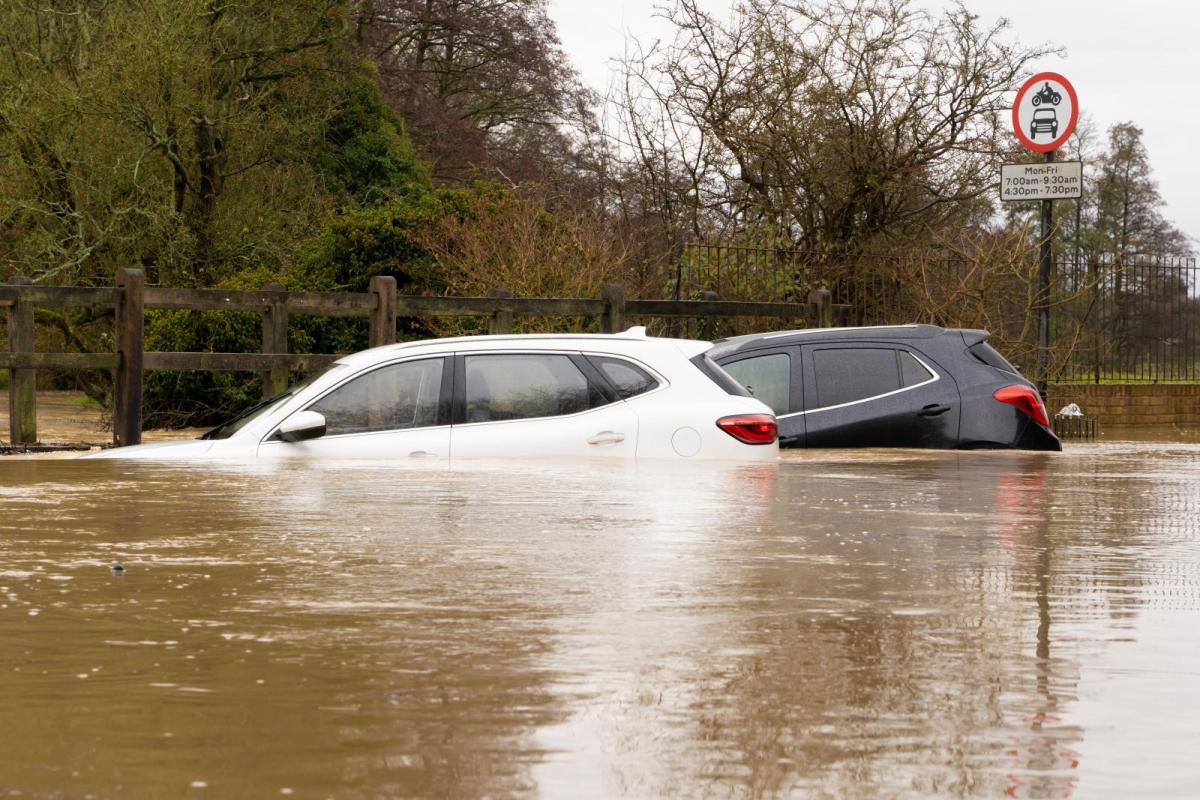
Biblical scenes of flooding developing across parts of eastern Scotland, following over a month’s worth of rain falling in less than 24 hours. Around 300 residents in the town of Brechin in Angus have been ordered to evacuate as flood defences have failed as the heavily swollen River Esk bursts its banks. Residents are being rescued by boat in the town this morning.
A rain gauge at Waterside Perth in Tayside, eastern Scotland has recorded 176mm in the last 36 hours, most of the rain falling in the last 24 hours. Other gauges in the area, river catchments in the eastern Grampians, recording over 100mm in 24 hours. Hence rivers in eastern Scotland are bursting their banks, with 5 Severe Flood Warnings and 15 Flood Warnings.

4 of the Severe Flood Warnings are in the Red Warning for rain area issued by the Met Office and in force until midday for 200-250mm of rain to fall in some locations by the afternoon. While a larger Amber Warning covering eastern Scotland is in force until 6pm for 150-200mm in upland areas before the warning expired. However, although the rain looks to ease through the day, all the rain that’s fallen still has to work its way through the river systems, so flooding will remain a risk for the rest of the day. Also, further rain, perhaps heavy and persistent, looks to return from the east tonight and into Saturday morning across eastern Scotland, so river levels likely to remain high in the current Red and Amber warning areas over the weekend.

SEPA Live Flooding Information

Further south across England and Wales another troublesome large area of rain has spread north and northwest overnight and looks to linger across northern England, west Midlands and Wales through much of the day. So across these areas 25-50mm can be expected quite widely, but across higher ground of the Pennines could see 80-120mm and here, along with SE Scotland, Amber Warnings for rain have been issued. So there is a risk of flooding likely from the Midlands and Wales northwards.

Natural Resources Wales Flood Alerts & Warnings
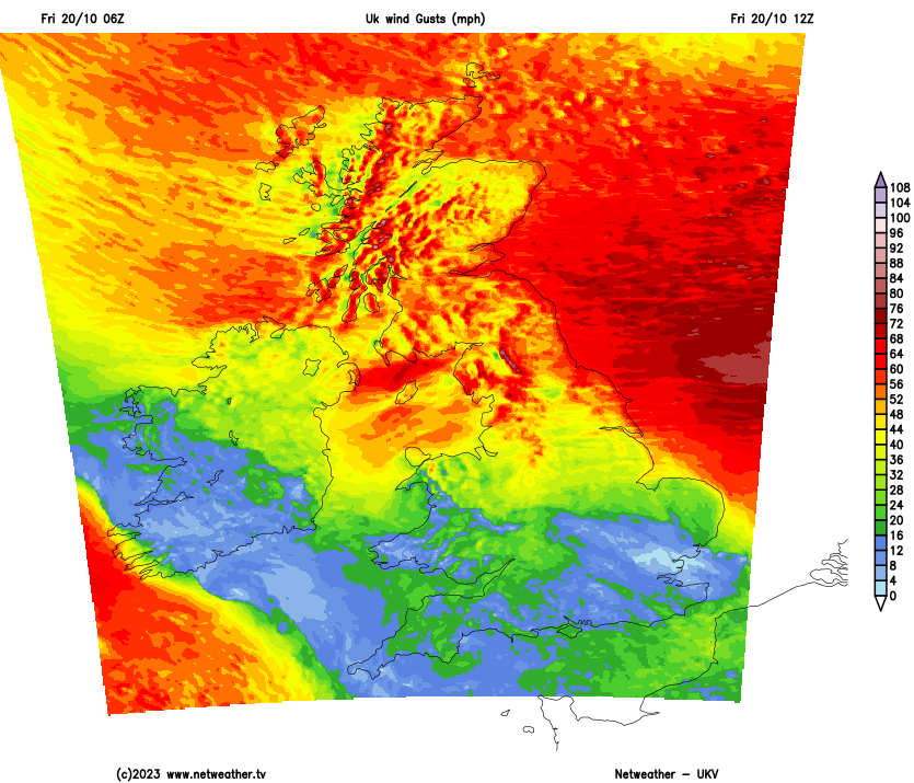
In more detail on what the weather is doing today, the persistent and heavy rain affecting the eastern side of Scotland is showing signs of easing this morning, but it is likely to remain cloudy with further light rain, the heavy and persistent rain becoming increasingly confined to SE Scotland. SW Scotland in a ‘rain shadow’ so here could stay mostly dry. Very windy, with gales, especially towards the east coast, recent gust of 64mph this morning at Inverbervie in eastern Scotland. Gusts of 60-70 mph possible along eastern coasts, 50-60mph elsewhere.

Further south, a lot of rain has spread north and northwest across England overnight and will become slow-moving across central and northern England, Wales and N. Ireland, with rainfall totals piling up, especially over higher ground, so increasing flooding issues likely to develop with rivers in these areas – while surface water building up will be a hazard on the roads. Very windy too aross central and northern areas, with the strong easterly wind gusting to 50-60mph towards eastern coasts and over hills. Southern England looks to see a drier day, but could stay grey and murky for some, while some bright or sunny spells could develop too.
Dunbar Harbour, East Lothian, Scotland this morning
"Wild conditions this morning along the North Sea coast with driving rain, gusty winds and huge waves crashing against the coast at high tide. I got totally soaked!" - Jo Farrow - Netweather Forecaster
Feeling rather cold in the strong easterly wind across northern areas, temperatures reaching 9-11C across Scotland and NE England, but feeling colder than this in the wind and rain. Further south over England and Wales, temperatures reaching 14-17C.
Rain eventually looks to ease north from England and Wales tonight, but likely remaining wet and windy over NE England while after a breather today, persistent and, at times, heavy rain looks to move back in across eastern and northern Scotland, perhaps turning to snow over higher parts of the Grampians – as cold air feeds in from the east. Some showers around southern and western areas further south.
We start the weekend with low pressure still in charge, with one area of low pressure moving east across southern England – bringing showers or longer spells of rain to south Wales, central and southern England. Another area of low pressure moving northwest over Scotland with further rain for northern and eastern Scotland – while turning drier across southern Scotland. Dry and bright in between. Still very windy with gales in the far north and windy in the southwest.

Sunday should see less rain, fewer showers and lighter winds, any showers becoming confined to coasts while most areas will have a dry and bright or sunny day. All change again early next week, as low pressure systems return from the southwest by Tuesday, bringing a return of wet and windy weather at times for the rest of the week.