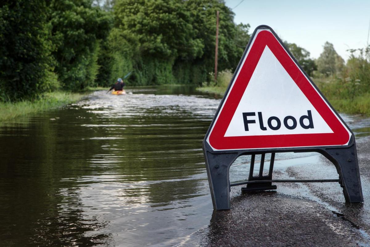
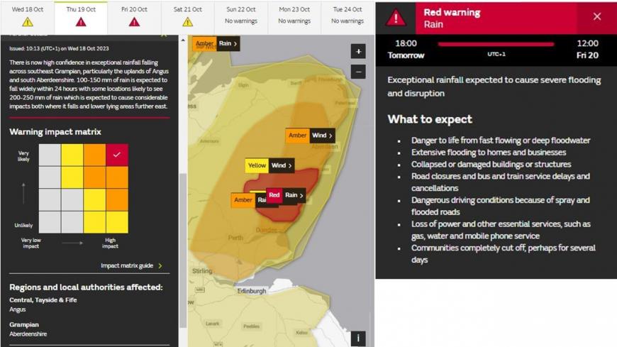
A danger to life Red Warning has been issued this morning by the Met Office for extreme rainfall over parts of eastern Scotland from tomorrow, leading to life-threatening flooding, as Storm Babet moves north. Also amber and yellow warnings in force for rain and wind for much of northern Britain.
Storm Babet is coming our way today, yesterday the storm was spinning to the west of Iberia, bringing heavy rain and strong winds to Portugal and southwest Spain. Portugal’s Faro airport in the Algarve saw flooding inside the terminal building following heavy rain.
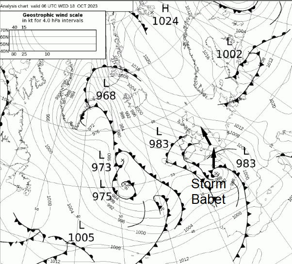
The troublesome low moved northeast over the Bay of Biscay overnight with the centre over Brittany at breakfast time. The low will move north across Britain today, bringing cloud and rain north across England and Wales through the day ahead, turning heavy from the south – while turning increasingly windy. Dry today for Scotland but the rain arrives from the south on Thursday and turning persistent and heavy rain across eastern Scotland and NE England throughout Thursday.
A rare Red Warning for rain has been issued for SE Grampian, with 200mm or more forecast to fall in parts of this area, with extensive flooding likely. Also an amber warning has been issued for strong southeast winds gusting to 70mph across SE Scotland, with amber and yellow warnings in force elsewhere across Scotland and northern Britain for rain.
While the rain should ease across the northeast on Friday, more rain returns further south across central, southern and eastern England – the rain possibly turning heavy and persistent across SE England and East Anglia, lingering into Saturday, so here could see a risk of flooding too.
Back to today, cloud and outbreaks of rain moving in across southern England and south Wales this morning will spread north across England and Wales through the day. A swathe of heavier rain looks to arrive across the south this afternoon with an area of low pressure moving north, before spreading north across England, Wales and N. Ireland through the evening. A brisk easterly wind across England and Wales, strong to gale force across the southwest this morning. Scotland mostly dry but windy today, with sunny spells. Temperatures reaching 13-16C.
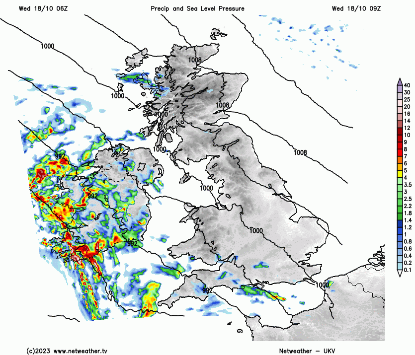
Storm Babet low continues to move northwards across Britain tonight, taking a band of heavy rain and strong easterly winds with it across northern England and N. Ireland overnight, reaching southern Scotland in the early hours. Dry across northern Scotland, while turning drier for a time to the south of the rain band, before showers spread in from the south across southern areas by the end of the night.
A set of weather fronts will grind to a halt across northern and eastern Scotland on Thursday, as the Storm Babet low’s progress any further north is hindered by a strong blocking high over Scandinavia. So persistent and heavy rain looks to linger across these areas throughout the day, eastern Scotland seeing highest rainfall totals – as the strong southeasterly wind piles in moist air which is forced to rise by high ground inland – bringing copious rainfall.
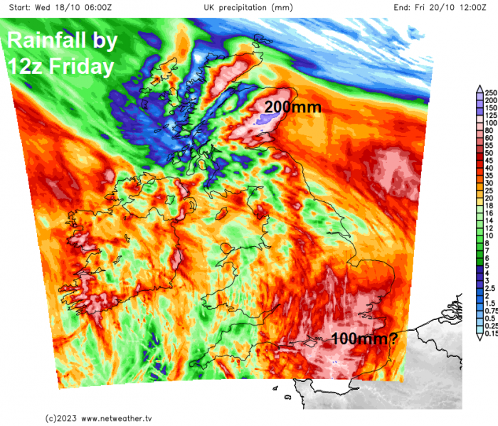
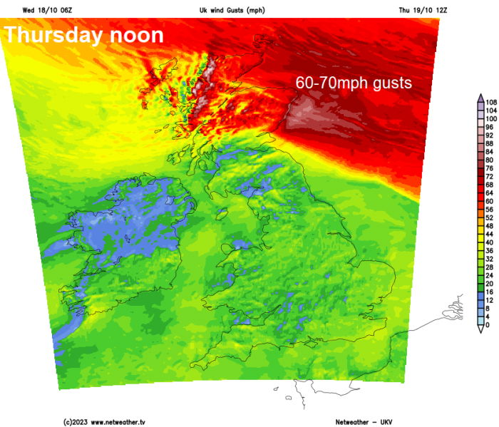
A rare danger to life Met Office Red Warning for rain has been recently issued for the SE Grampian area of eastern Scotland between 6pm Thursday and noon on Friday for the potential for 100-150mm to fall widely, with 200-250mm falling in some locations – leading to extensive flooding, damage to properties and major disruption. Also, there are amber warnings in force for rain across much of eastern Scotland and an Amber wind warning in force across parts of NE Scotland for the potential for gusts to 70 mph towards coastal areas of eastern Scotland. Elsewhere, there are yellow warnings in force for rain across Northern Ireland, eastern and southern Scotland.
For England and Wales, Thursday will see persistent rain develop across Cumbria and NE England – upland areas in these parts could see 70-100mm of rain – which could lead to flooding and disruption. Further south it’s a case of sunny spells and showers spreading north, showers locally heavy with a risk of thunder – especially in the south. Temperatures reaching 12-15C across Scotland, 15-18C across England, Wales and N. Ireland.
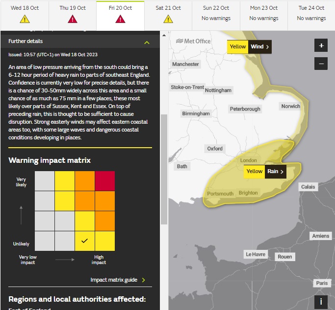
Persistent rain should ease across eastern Scotland through Friday morning, but may persist across NE England, while the risk of flooding and travel disruption likely to continue in these areas. Further south and we’re watching developments over northern France – where the models are now picking up on a low developing there and moving up to the North Sea which could pull in persistent and perhaps heavy rain accompanied by strong winds across SE England, Midlands and East Anglia through the day, some high rainfall totals showing for far southeast (up to 100mm) – a yellow rain warning has been issued for the risk of flooding, with up to 75mm across parts of Sussex, Kent and Essec. Elsewhere, it will be drier and sunnier towards the west.
The weekend could start wet and windy across eastern areas before becoming confined to the northeast. Otherwise, winds easing and becoming drier and sunnier from the west through the weekend, though risk of a few showers around southern coastal areas.
Loading recent activity...