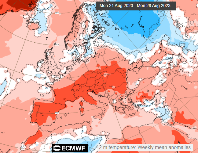
Warm and humid air will pulse across the Channel again later this week but a low pressure off Scotland will turn the airflow to a northerly by next weekend as Spain and France swelter.
This time next week there will be a Bank Holiday in the UK (not for Scotland). The forecast doesn’t look ideal. If you were hoping for some late summer heat, it’s across in mainland Europe again, where this summer has been extreme. We get a showery northerly flow, with only sunny spells giving warmth.
“Intense and long-lasting heat wave, particularly late for the season, requiring special vigilance.” Meteo France Red warning "exceptional in the Rhône Valley and southern Massif Central due to its intensity and duration"
Before that, there is some warmth to be had in the current south to southwesterly flow. It has felt warm, even muggy in that air and heat will waver across from France occasionally this week. Temperatures in southeast England could reach 28 or 29C but it’s not the extreme heat that the UK saw last summer. Currently, temperatures during the Bank Holiday weekend look to be high teens and low 20sC.
Storm Betty gave strong and gusty winds on Saturday as the low cleared away northwards and the north and west of the UK are still windy with outbreaks of rain and more cloud today. Low pressure will lurk close to northern Scotland all week with temperatures staying in the mid to high teens.
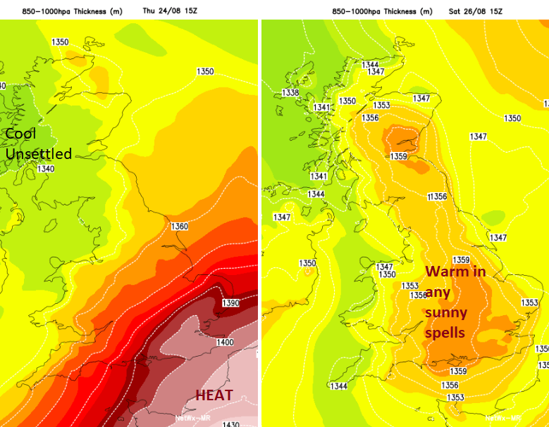
High pressure is over much of mainland Europe Mediterranean extending down to the Mediterranean on Monday and Tuesday with plenty of hot and humid air. This fine weather will reach southern Britain until another little low pressure nips in off the Atlantic later on Wednesday. The heat tries to wave its way across the Channel but by the weekend, it’s gone as the flow turns more northerly.
Cooler and fresher air then reaches down through the UK, bringing showery outbreaks of rain and an August Bank Holiday cliché.
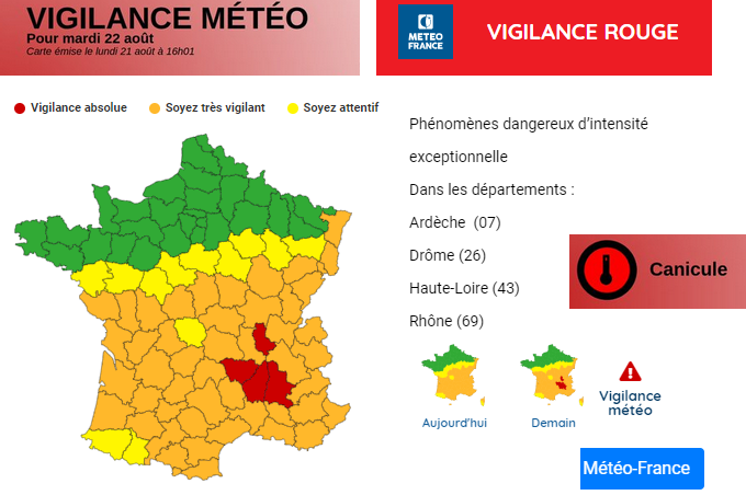
Red warning from Meteo France for Tuesday 22nd August
“A lasting and intense heat wave for the period has settled over the country. “ Vigilance Meteo France "The heat wave peak is expected around Wednesday (and temperatures may still remain very hot on Thursday). Some absolute records are likely to be broken, especially Tuesday and Wednesday towards the Rhone Valley, with 40 to 42 degrees expected."
Meteo France has heatwave (Canicule) warnings this week. This is away from northern areas but temperatures in the south and east have already reached the high 30sC just into 40sC. There are other warnings of high temperatures from Switzerland, Germany, Poland, Italy, Croatia, Greece, Hungary Austria and Lithuania. (WMO)
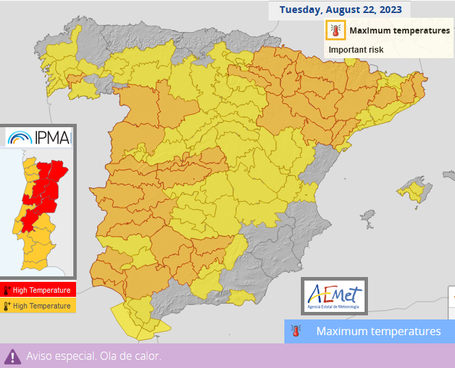
Spain announced another heatwave on Sunday which will last through until at least Thursday with various high temperature warnings across the land. Here also temperatures will be in the high 30s and just into the 40sC and the heat will surge northwards towards Cantabrian Sea coasts.
Both Spain and France should see some relief from the worst of the heat by the weekend.
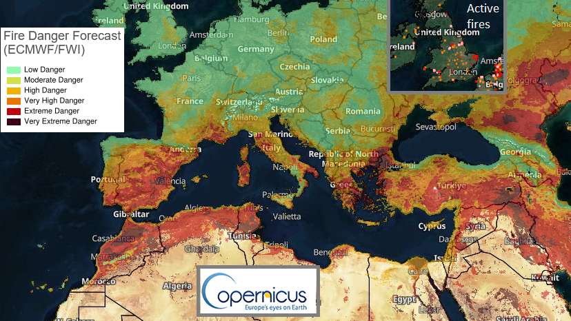
There are also more wildfires and an extreme fire risk, where conditions are ripe and poised, that if a fire did occur there would be huge impacts in that area.
So maybe a summer without extreme heat isn’t all bad. As August draws to a close it is a shame that there haven’t been more fine, sultry settled spells. And that the UK weather is taking a fresher turn for the late summer Bank Holiday weekend although it will still feel warm in any sunny spells.
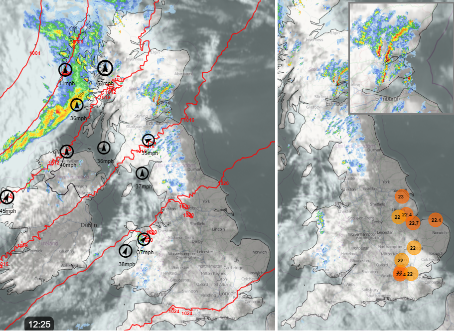
The UK rainfall over the next few days will mostly be from showery outbreaks from the west (particularly in the northwest) until the new little low moves through on Wednesday/Thursday with frontal rain. The detail of where this will affect is likely to change. Then a shift later on Friday as the northern low centre rolls down over the UK and brings a showery cooler flow for Friday night and the start of the weekend.
The dig of fresher air will make its way into France and Spain but the heat seems to hold on for Italy and the Balkans through the central Mediterranean at the weekend.