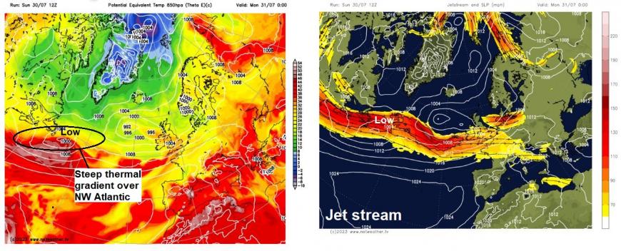
The weather charts for this coming week have a decidedly autumnal look to them, more akin to late October or November than early August. An unusually persistent jet stream, running further south than normal for late July / early August, will flow east from NE Canada to southern Britain through the coming week, thanks to the steep thermal gradient in the troposphere between cooler arctic air associated with extensive upper troughing over northern Canada, Greenland and far North Atlantic and warmer sub-tropical air moving up from Bermuda. The jet stream will carry two areas of low pressure with it to the British Isles over the next few days.
The first one will not be too troublesome, moving in across Scotland on Monday, the occluding frontal system moving ahead of the low bringing cloud and rain eastwards across England and Wales this afternoon, reaching Scotland tonight. Often cloudy with showers for many Monday, perhaps more organised areas of rain across Scotland and northern England as the low arrives across the far north.
However, the second low arriving from the Atlantic on Wednesday, on a more southerly track, looks more troublesome, especially if it deepens as much as some models suggest – bringing a risk of gales in the far south and some heavy rain followed by heavy showers and thunderstorms across much of England and Wales.
The jet stream looks to strengthen upstream on Tuesday, as the thermal gradient over the far NW Atlantic tightens even further, with a jet streak pushing east over the North Atlantic at the rear of a sharpening shortwave trough moving east. The left exit of the jet streak and sharpening shortwave upper trough will create upper level flow divergence and low-level convergence that will serve to deepening a surface low moving east over the Atlantic, which will be just south of New Foundland tonight. The low looks to steadily deepen as it crosses east over the Atlantic tomorrow, before moving on to the cold (polar) side of the jet stream on Tuesday where it will encounter stronger divergence in left exit of jet stream – with a quicker deepening of the low as it approaches the SW of the British Isles. 00z ECMWF has the low centre deepest as it crosses southern Ireland and Celtic Sea Wednesday morning before starting to fill as crosses Wales, Midland and exits eastern England early evening.
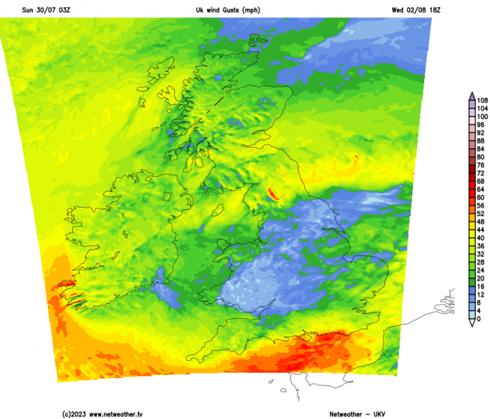
UKV wind gusts 3pm Wednesday
ECMWF wind gusts noon Wednesday
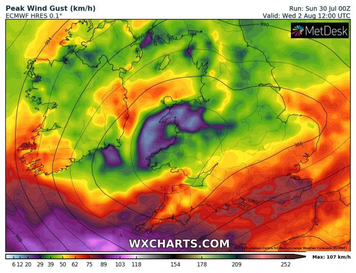
Strong winds are modelled to develop on the southern flank of the low, with high-res models ECMWF and UKV showing 40-50 mph gusts inland over southern coastal counties, 50-60mph along coasts. Obviously, being the school summer holidays, many people will be camping, in caravans and generally staying and doing outdoor activities near the coasts – especially popular coastal areas of Cornwall and Devon. So, I would expect the Met Office will need to issue wind warnings for wind, with the potential for rough seas overtopping sea defences, high winds along exposed coasts and hills causing some issues, particularly for those camping or with outdoor events, but also a risk of tree branches falling down and causing issues on roads and rail tracks.
As well as the strong winds, outbreaks of heavy rain spreading quickly northeast across much of England and Wales will precede the low arriving from the west, followed by strengthening winds and blustery heavy showers and thunderstorms. Scotland, for now, looks to escape the worst of the wind and rain, with a brighter day with a few showers.
As Wednesday’s low exits east out over the North Sea, a northerly wind looks to blow both Thursday and Friday, bringing cool air and a scattering of showers both day, some of which will be heavy with hail and thunder locally. So, an unseasonably cool and unsettled week ahead.
Loading recent activity...