Rain and plenty of showers in the forecast for the rest of the week. Any sunny spells will still feel warm but passing showers will keep us on our toes for midweek.
Low pressure has moved across the UK overnight and will take its time today to centred itself over Shetland. There will be plenty of showers around today, again with some heavy downpours, even thundery ones. There looks to be a warmer, drier lull on Thursday but more low pressures are waiting to head our way at the weekend.
So overall there is an unsettled theme with bright spells and then hefty showers passing by. Today there is a blustery south-westerly wind across England and Wales. For Northern Ireland, a light north-westerly wind making it feel a bit fresher and there will be lighter cyclonic winds for Scotland closer to the low centre. These winds help drive the showers well inland.

Convective forecast for Tuesday "Areas most likely to see a thunderstorm look to be across eastern Ireland, N Wales, N Midlands, southern half of N England and eastern Scotland."
If you are in a sheltered spot where the July sunshine appears it will feel warm as temperatures rise into the high teens or low twenties. Marham, Norfolk saw 26.4C on Monday ahead of the cold front which is over SE England this morning. The air will feel a bit fresher for East Anglia and London today although there will be a lot of cloud and outbreaks of patchy rain. Dedham Vale and Mersea Island could reach 23C and will feel warm. As heavy showers develop over Wales, SW England and the Peak District today, it will feel cooler and Scotland keeps a rash of slow-moving showers.
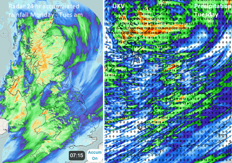 Accumulated 24-hour rain til 0715 Tues from Netweather Radar and forecast 24-hour rain on Tuesday
The southeast of England isn’t going to see much rain over the next few days but there could be some brief interruptions to play at Wimbledon. Temperatures will be around 22C with a fair amount of cloud and a small risk of a passing shower.
There will be plenty of showers coming onto the north coast of Londonderry and Antrim. Manchester and the Peak District could catch many of the showers in a westerly flow and Wales, Cumbria up and along the border with Scotland also looks prone to heavier downpours. SW Scotland and NE England look a bit more sheltered today. Southeast England up to Suffolk miss most of the showers through the midweek period.
 UKV model forecast rain through midweek
Later today an area of heavy showers will move from Yorkshire, Wales and Somerset/ Devon into the Midlands and over more of the West Country. Rain just continues for exposed parts of Northern Ireland and the northern half of Scotland.
By Wednesday morning there will be clusters of showers for NW England. It will be another day of bright or sunny spells with showers and plenty of those for Scotland and the north coast of Northern Ireland. Again, there will be the risk of some heavier downpours and thundery ones.
Temperatures by day don’t change too much this week although Thursday night looks a bit cooler as air is dragged down from the northwest behind the low pressure.
By Friday and for the weekend it will be frontal rain sweeping the country, not just showers. There will be bands of rain rotating around the incoming low pressures. Weather apps won’t help at this stage with timing details but there will be longer spells of proper rain from the southwest rather than fleeting showers that have passed by. For Scotland and Northern Ireland, it is just more unsettled weather but further south this will be a change to proper wet weather which lasts longer. There will also be blustery winds around the low pressure.