SE Britain will reach the mid 20sC today. Rain for other parts with the risk of heavy showers, even thunderstorms. SE England manages to miss most of the showers this week during a fresher week.
The weekend's heat and humidity has eased and this week will continue to feel fresher with a flow off the Atlantic. Temperatures will be in the high teens to low twenties although East Anglia and Greater London will be warmer today, at 24 or even 25C. It will feel cooler as the showers pass by.
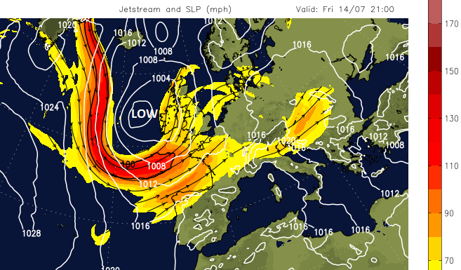
A series of low pressures affect our UK weather this week, bringing showers and rain at times
This week there are great meanders in the Jetstream with large low pressures developing near to the UK. These take their time to move on and will bring blustery showers from the west after today’s frontal rain from the southwest. There will be bright or sunny spells around this week but it’s time to keep a brolly in your bag, especially further west. Wimbledon should escape most of the rain and showers this week, but there could still be a few short-lived interruptions for the outside courts.
Top 10 highest gusts and temperatures with Netweather Extra Radar and Convective Forecast
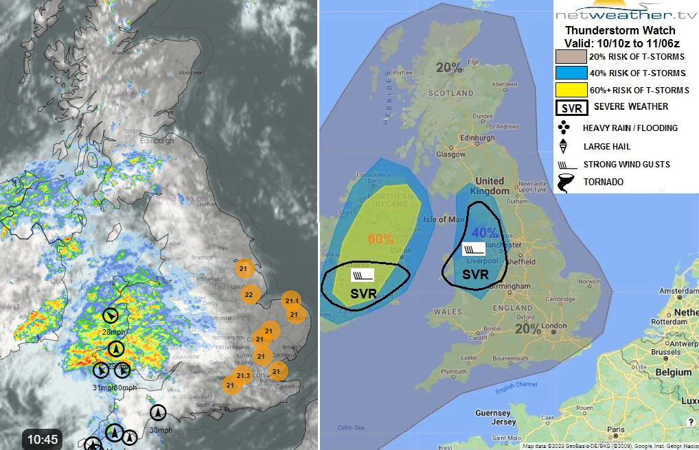
A brisk southerly wind will follow the main bands of rain which spread northwards today through Wales, Northen Ireland into NW England and more of Scotland. With hardly any breeze over northern Scotland there will be showers bubbling up in-situ and these will include some heavy downpours. Through the afternoon the showery rain will reach across to northeast England. Northern Ireland has a thunderstorm warning from the Met Office for this afternoon and evening which could bring impacts to travel later today.
Convective Forecast - "Strong southwesterly jet aloft over S Ireland & mainland UK will allow organisation of storms into clusters / line segments, perhaps an isolated right-moving supercell, capable of producing strong wind gusts of 40-50 mph – more especially across S. Ireland, N Wales and into NW England"
A trailing front will bring more rain into SW Britain this evening. This edges towards The Wash during the night and will include some heavy pulses of rain.
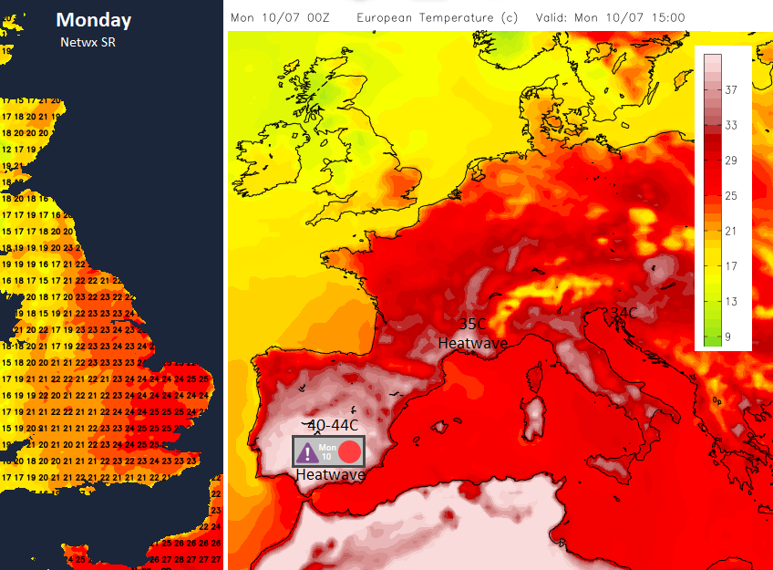
Intense heat further south in Europe
The top temperature on Saturday was 28.9C near Norwich, Edinburgh reached 26.5C and the Isle of Lewis saw similar which was hot for the Western Isles. Much of eastern and northeastern Britain saw 27 or 28C but it was the high humidity that gripped the day, not the air temperature values. There is intense heat building over northwest Africa which is bringing high temperatures to Spain and the Algarve today. There are already Heatwave warnings in place. If you are travelling, do keep an eye on MeteoAlarm initially as this coordinates many of the national weather services warnings in one place and provides links to the official websites. This heat is also affecting the western Mediterranean and will surge up through Italy, the Alps and France on Tuesday and lift the temperatures in Paris to over 30C.

This heat won’t affect the UK as low pressure moves over the UK on Tuesday. There will be a rash of showers developing but without the larger areas of frontal rain that will affect parts of the UK today. Scotland and Northern Ireland look most prone to seeing clusters of heavier and more frequent showers with the risk of heavier ones, and again thundery downpours. It will be worth keeping an eye on the Netweather Radar over the next few days.

The low pressure begins to edge towards Norway and its cold front digs down into mainland Europe, easing the heat for France and Germany. The UK sees another scattering of showers on Wednesday, particularly for Scotland. They are pushed well inland by the west to northwesterly breeze, right across Britain but with large drier, brighter gaps in between. Thursday sees fewer showers and lighter winds.