Thunderstorms are developing across parts of the UK today as a brief plume of hot, humid air destabilises. In the longer term, the unsettled theme will continue, with temperatures generally near average.
Thunderstorms are the main talking point for the UK's weather this weekend. At one time, the current hot southerly episode didn't look likely to come to much, but during the past week and a half, the forecast models have progressively toned it up, resulting in the classic "two or three fine days and a thunderstorm" pattern.
Unsettled weather with westerly winds and low pressure will return next week. Still, with the continued exceptional warm temperatures in the eastern North Atlantic, temperatures will tend to be around average for the time of year during next week rather than cooler than average as we would typically expect in such a westerly regime at this time of year. With the emphasis often on bright and showery weather rather than persistent rain, for many of us, sunshine amounts may also end up near normal next week.
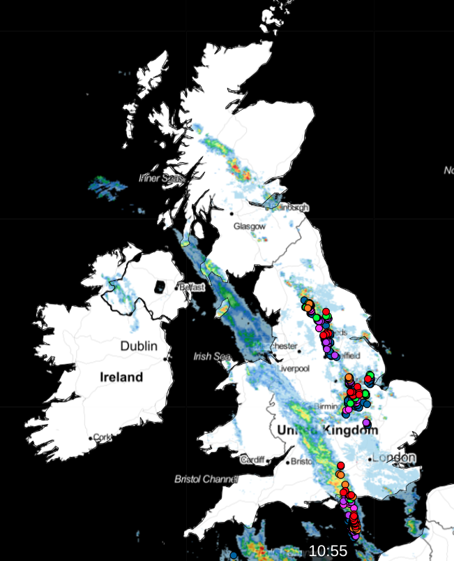
We currently have a line of showers and thunderstorms through the east Midlands, into west Yorkshire, and parts of the Scottish Lowlands. This is forecast to push northwards, particularly affecting north-east England and southeast Scotland around midday, with some continued embedded thunderstorms.
 See the latest on the live radar.
Another band of showery rain currently over southwestern Britain will follow behind into the same areas. This may produce some thundery activity in southeast England, but most parts of the eastern half of England will see a short spell of rain from it. During the afternoon, we can expect further thunderstorms to develop in north and east Wales, north-west England and up the western side of Scotland. The evening could see further showers and thunderstorms develop to the east of this area, through Lincolnshire, Yorkshire, north-east England and into eastern Scotland. For Northern Ireland, it will be a generally dry day with sunshine and just isolated showers, and southern England will also become predominantly dry and sunny during the afternoon and evening.
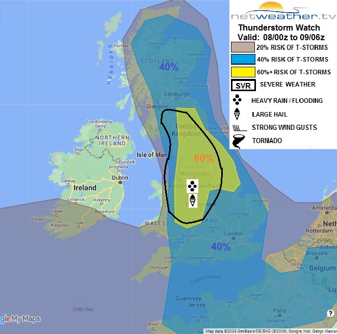
A severe thunderstorm watch has been issued for today.
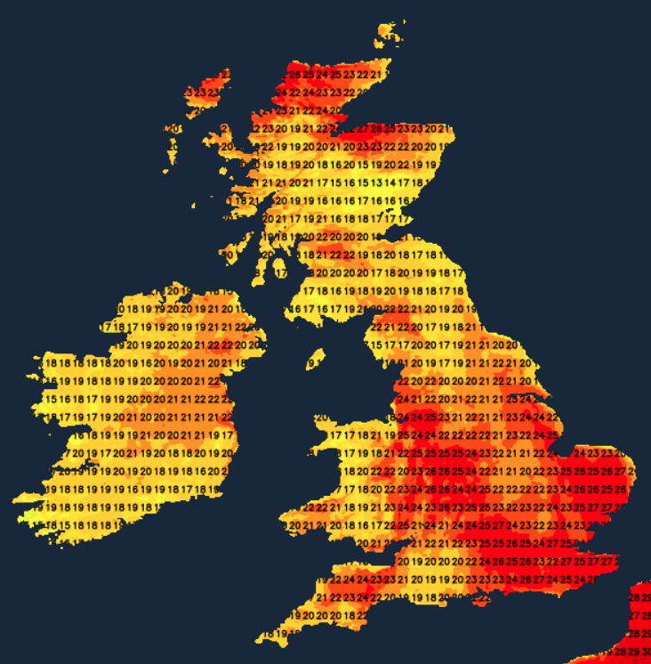
It will be a hot day in eastern Britain - much of the eastern half of England can expect highs of between 27 and 29C, and 30C locally. Temperatures will also reach the high 20s Celsius over much of northern Scotland. Elsewhere, highs of 22 to 25C will be typical.
An area of rain, with the potential for embedded thunderstorms to persist for a time, will push through Scotland overnight, the thundery activity probably dying out as the night progresses. Most places will become dry with clear spells, although some showers will push into western areas towards dawn. It will be a warm and sticky night in eastern England, with temperatures not falling below 15 or 16C in some places, though cooler weather will generally push in from the west, and much of western Britain will fall to between 10 and 12C.
Sunday will be a fairly cloudy day in East Anglia and southeast England, and some rain will affect south-eastern counties bordering the North Sea for a time, perhaps with some embedded thunderstorms for Kent and Sussex in particular. It will brighten up in these regions by evening. Elsewhere, it will be a bright day with scattered showers developing after a generally dry start, although some places, particularly in Scotland and southern England, will remain dry. Some heavy and thundery showers are expected to develop in Northern Ireland, east Wales, the Midlands and northern England. Although it will be cooler than today, much of eastern Scotland and the majority of England will see temperatures reach between 22 and 25C. In Wales, Northern Ireland and western Scotland, highs of around 20C will be typical.
After a dry and sunny start to the day on Monday, an area of cloud and rain will spread from the southwest during the day, followed by brighter weather with showers, some of which may again be thundery in places. Sunshine and showers will be the dominant theme through Tuesday and Wednesday, though with fewer showers on Wednesday when many places will stay dry. The changeable theme will continue for the foreseeable future, with temperatures staying average despite the mainly westerly winds.