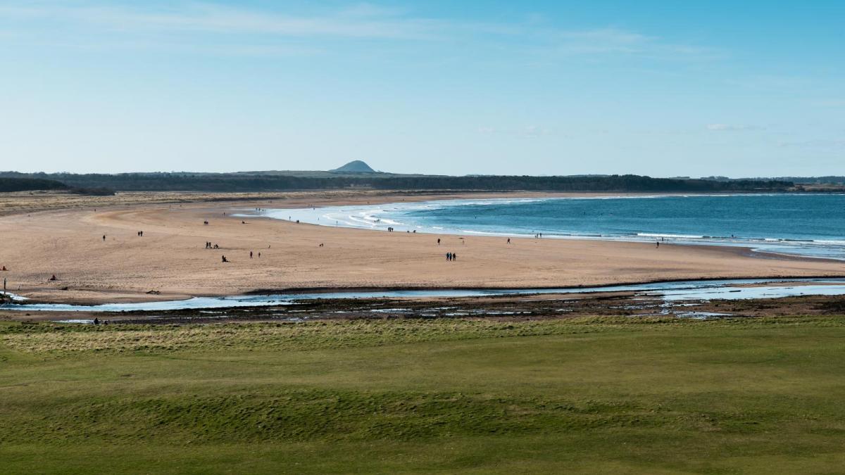
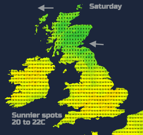
Already the cooler air has begun to fade this week, signs that something warmer is on its way. There is a closeness in the air, and less of an edge to the breeze. The top temperatures in the UK will be 20 to 22C which will feel pleasantly warm in strong sunshine. This isn’t going to be like any Bank Holiday heat that you may remember from a late May one in previous years, but it will feel warmer than it has recently.
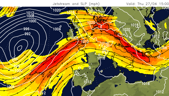
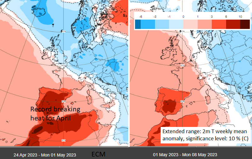
The Jetstream has been further south. There has been cooler air to the north, for the UK, France, Denmark and down to the Balkans with a tuck of warm air in the far NE of Europe, over Finland. To the south, Spain and Portugal (and Morocco) have seen record-breaking April heat as hot, dry, dusty air poured off north Africa to Andalucía and southern Portugal. Here there have been temperatures widely well over 30C, already passing 35C and 38C this week. AEMET said ‘Highs more typical of the beginning of July’ than April. And on Thursday 27th April, provisionally, recorded a new April record for mainland Spain, in Cordoba and for Portugal in Mora.
Signs of a shift for the UK next week *
There is a warming trend in the UK forecast but a gentle one. We did have some warm spring sunshine in April, that faded. There is the Early May Bank Holiday weekend coming up with a mixed picture but it does include some warmth. The Iberian heat does decrease at the weekend as it spread eastwards over the western Mediterranean, so we aren’t going to see that.
The jet stream is going to change. The zonal stronger jet which has been moving across the Atlantic west to east begins to meander and buckle.
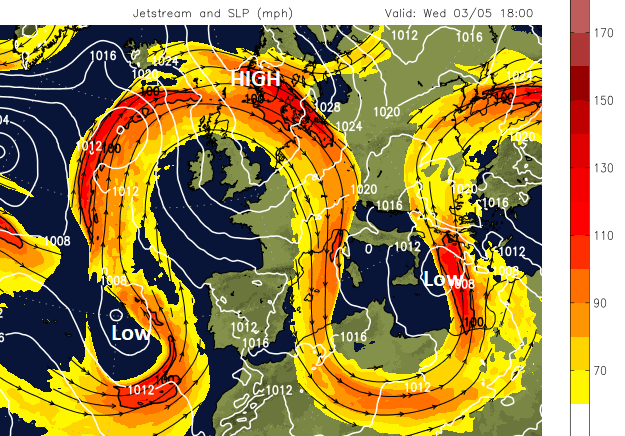
Recently the jet has been purposefully driving its way across the Atlantic. With a large area of cool air in the north, and Spain on the warmer side with hot air from Africa. If you imagine setting 10 people off, to walk across a football pitch from one point to the other side, they would all (hopefully) end up on the other side but might have spread out a bit. The main theme would still be strong. In the coming week, we huge meanders develop in the Jetstream. Imagine setting off those 10 people but with less constraints, maybe with a cone or two to guide their journey. The resulting patterns won’t be as consistent, there will be variations and not the strong overall outcome.
Ensemble forecasting looks at a number of outcomes for trends rather than one (deterministic) solution. There are signs for next week that a huge meander will draw up some warmer air from Spain, through France and by midweek towards southern Britain but it’s not a strong feed. Surface high pressure is showing over the North Sea and the UK and anchors one of the loops in an Omega Block. “Omega blocks are named due to pattern they form which resembles the uppercase Greek letter omega, Ω.” High pressure with two lows, one on either side. It’s a steady setup. However, this draw of warmer air from the south looks like it will be interrupted, probably before the Coronation Bank Holiday weekend. The ECM model shows an easterly flow interrupting and the GFS has a westerly with an Atlantic low moving in.
Cold air skims the far north of Scotland this weekend, keeping a wintry element to any showers over the Cairngorms and NW Highlands. There will be chilly nights too and Saturday night looks cold with the risk of frost for northern and eastern Britain. Growers and gardeners should take note and anyone planning a camping trip over the long weekend. Even into next week, some parts of the UK will still see temperatures falling well down into single figures where there are clear spells overnight.
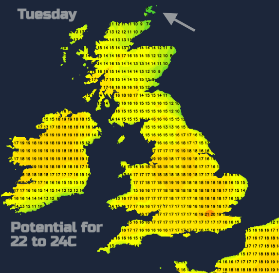
The next few days are looking warmer but some areas will see showers or even thundery downpours. There is the potential to move into the low twenties Celsius for southern Britain, especially Greater London where the sunshine breaks through. After midweek it depends on the air flow. In an easterly set up with some sunshine, Manchester, Glasgow, Bristol could all see 21C by Thursday whereas the east coast would be cool and grey. If there is a switch to a westerly during the second bank holiday weekend, then eastern Britain, eastern Northern Ireland will see the temperatures lift and western areas become cooler and most unsettled. We’ll have to see how the blocking high holds on.
Understanding the extended range anomaly ECM chart *
This chart shows 7-day mean anomalies of 2 m temperature from the ECMWF extended range ensemble. The mean anomalies (in ºC) are derived from the ECMWF extended range ensemble consisting of 50 ensemble members plus a control member and averaged over a seven-day period.
Air temperature at 2 metres above the earth's surface is a post-processed product that is derived by non-linear interpolation between model temperatures at the lowest model level (at about 10 metres above the surface) and temperatures forecast at the model earth's surface. The anomalies have been calculated relative to model extended range. They are based on the proportion of ENS forecast members which meet the anomaly criteria and are coloured according to a non-uniform scale. The shaded areas are at 10% significance level, contours are at 1% significance level. Blank areas show where the ensemble forecast is not significantly different from the extended-range climatology.
Loading recent activity...