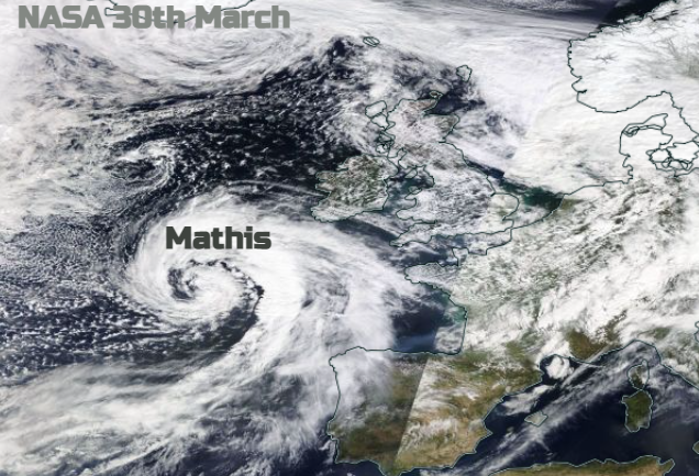
As Storm Mathis moves in for Thursday night there will be severe gales through the English Channel. Rain will spill over southern Britain with veering strong winds and high gusts for the south coast.
It will be very windy through the English Channel during Thursday night and Friday. The Atlantic low responsible has deepened out west and now is slowly filling as it heads towards the UK. It has just been named by Meteo France as tempête Mathis (#StormMathis). The southwestern group has been romping ahead with the storm naming. For our Western naming group, we haven't even seen an 'A' yet.
If you are looking at a weather app to see if strong winds/ gales or heavy rain will affect your area tonight or on Friday morning, do just be aware that there is still some uncertainty. The current setup has moderate confidence about a swathe of severe gales through the English Channel overnight, but wild conditions could creep a bit further north than model output is showing on the symbols display. The UK Met Office has a yellow wind warning around the Bristol Channel and for coastal southern England running from Thursday evening until Friday lunchtime. Meteo France also has yellow warnings but for wind, thunderstorms and heavy rain.
The sea areas through the English Channel include:
Plymouth - Southwesterly gale force 8 expected soon, increasing storm force 10 later. Sea State Rough or very rough, becoming very rough or high later, occasionally very high later.
Wight - Southwesterly severe gale force 9 expected later. Moderate or rough, becoming very rough or high later in west.
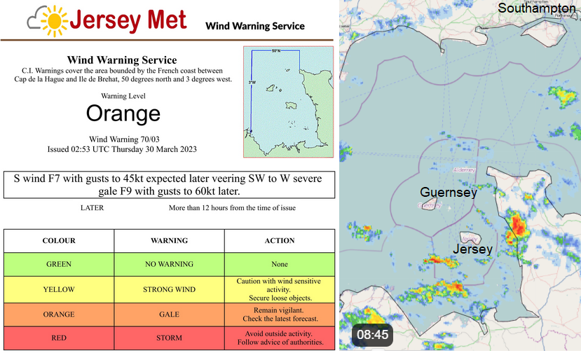
Jersey Met South fresh F5, increasing strong F6 to 7 by midnight, veering southwest to west severe gale F9 later, with gusts to 70mph. The Inshore Waters forecast for the Channel Islands keeps the high gusts until mid-morning Friday with Sea state - "High in the north and west until early afternoon, otherwise rough to very rough”

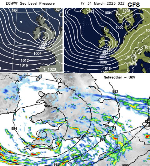
Heavy rain will set in over Cornwall and Devon this evening as the southerly winds freshen. Frontal rain pushes over Wales and across southern England with heavy pulses and bands of hefty showers following through the night. With the strengthening winds it will sound wild outside. By 4am on Friday morning, the low centre should be over SW Britain with the winds veering to a westerly. The main core of severe gales is over the water, along the English Channel.
The UKV model shows a wild start for Friday for the Channel Islands and north coast France but Cornwall and Devon, particularly the coasts and moors could see gusty winds picking up from the west for the morning rush time. For the Isle of Wight eastwards around dawn the winds should be from the southwest and hitting the south coast, then veering to a westerly mid-morning.

Friday morning looks wet and windy for southern England, and south Wales including Cardiff. Easter Holidays will soon be starting and with driving rain and these strong, gusty winds conditions will be tricky on the roads. There may be delays to ferry services and wild weather along the south coast. If the corridor of strongest winds nudges a bit further north then there is the risk of severe gales affecting exposed parts of Channel coasts for southern England on Friday morning.
Community Forum thread for overnight and Friday 31st Storm Mathis