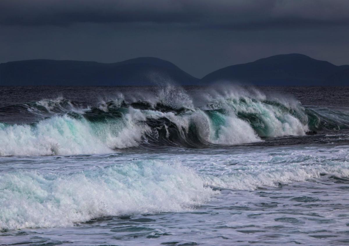
Becoming increasingly wet and windy tonight with concerns for western and northern Scotland on Wednesday morning from strong to gale force winds, high gusts, high tides and large waves.
The next Atlantic system is bringing rain and freshening southerly winds for Tuesday evening. Northern Ireland, SW Scotland, and Gwynedd have a wet end to the day as eastern England is feeling very mild at 15C with sunny spells. A warm front, cold front and occlusion will race across Ireland and the UK tonight with a spell of wet weather and it will be windy, even stormy for a time. There are also flooding concerns around the high spring tides 6am til 8am Wednesday morning in the wild conditions.
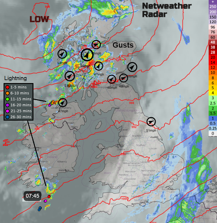
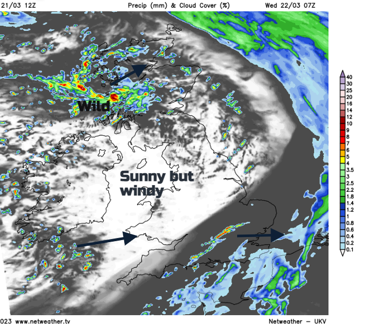
Updated radar Wednesday morning showing 10 highest gusts, model pressure, IR cloud and rain with sferics
“… will strengthen overnight into Wednesday with gales along southern and western coastlines and severe gales or storm force winds likely for southwest Scotland. Winds largely easing to a sub-gale threshold through Wednesday although will be blustery in showers.” Inshore waters
There will be fresh to strong southerly winds which veer post front to a gusty south-westerly and the UK stays windy through Wednesday. There is a yellow Wind warning from the UK Met Office over a swathe of Scotland for Wednesday. There are already ferry service cancellations to the islands off the west coast.
Network Rail Scotland has announced they will be “limiting train speeds on these routes for safety reasons between 02:00 & 14:00 tomorrow.” (Weds 22nd) ‘While we don't expect major disruption, it's a good idea to check with your operator before heading to the station tomorrow.’
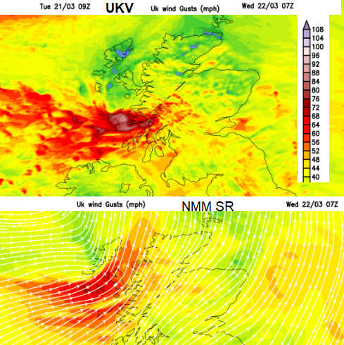
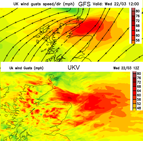
To start Wednesday there will be strong winds for Northern Ireland, the North Channel, Irish Sea into NW England and across Western Scotland. The warning runs from early morning through lunchtime with gusts of 50 to 80mph forecast. The UKV Model highlights a core of ferocious gusts around 7am near to Tiree and Mull with wild conditions for western Scotland heading up the Great Glenn for 8/9am. Other models have the strongest gusts slightly further north, over Skye, The Minch and the far north of mainland Scotland. And the risk of severe gales for the far north of mainland Scotland, over exposed coasts and hills. There will be heavy rain around this feature, a small low centre which is drawn on the FSXX (T+24) chart. In the stormy conditions, there is the risk of coastal flooding.
“Large waves, strong winds and high tides over the next couple of days may cause impacts such as wave overtopping as well as flooding causeways, promenades, properties and roads.” SEPA
Remember Met Office warnings combine likelihood and impacts. This could be impactful for western Scotland on Wednesday morning, with the wild weather, large waves, heavy rain for a time and high gusts. Northern Scotland is also likely to see impacts with tricky conditions for a time on the A82, A87 and A9. Other parts of the UK will also have a spell of noticeably windy weather midweek but the heavy overnight rain will be clearing away. Clusters of sharps showers will affect a few areas but there will be a good deal of sunshine away from the far north.
The Environment Agency has also highlighted the risk of coastal flooding "along the south coast of Cornwall during Wednesday and Thursday early morning high tides. And there are flood alerts for Pembrokeshire and Ceredigion coasts from Natural Resources Wales.
Name our Storms 2022/23 Still awaiting Storm Antoni