Amber warning now for heavy snow. More rain, sleet and snow is forecast over the next few days with concerns about ice and also deteriorating conditions on Thursday as the winds strengthen.
Update to include Amber warning for heavy snow on Thursday 9th March
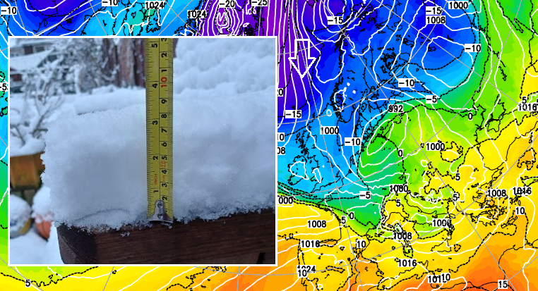
Southern England and Wales have seen snow to start Wednesday. The excitement of opening the curtains and there being a covering of the white stuff, even if it is rather wet and slushy. There have been several cms in Surrey, Berkshire and the Cotswolds and there are two other bouts of snow in the forecast over the next few days. Ice will be a widespread issue as temperatures fall after dark. The forecast has a tricky balance of rain, sleet or snow. Do bear in mind that wintry weather is forecast over the next few days and prepare, even reconsider, if you are hoping to travel on Thursday as an Amber warning has now been issued.
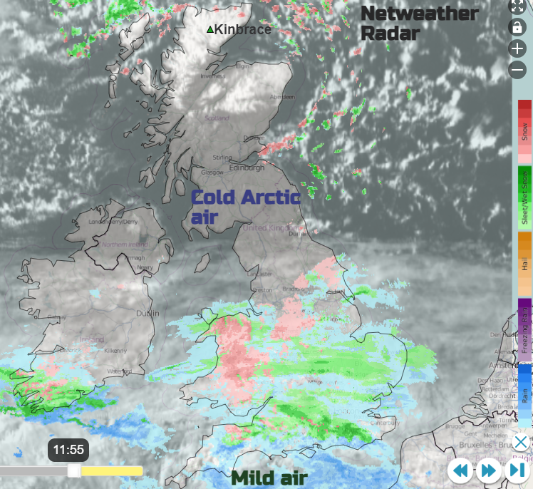
Highland Scotland saw temperatures fall to -15.2C last night and -8.5C in County Tyrone. The snow showers reaching northern Scotland will ease off into Thursday but it will be another cold night for Scotland with wintry conditions continuing due to lying snow and ice. Thin high cloud will reach Northern Ireland and northern England so not quite as cold here but still sub-zero.
That high cirrus is linked to the next frontal system pulsing in later today. This will bring another band of rain, sleet and snow. Wales looks to bear the brunt of this and the mixed wintry precipitation will spread across the Midlands into East Anglia. A smaller area of heavy rain is forecast to move across southern counties of England during the night in the milder air.
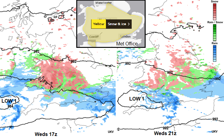
The UK Met Office has a yellow warning across inland southern Britain but it has been shifted slightly further north into Derbyshire, but still includes the high ground of Exmoor.
“Spells of snow and icy patches may cause travel disruption during Wednesday into Thursday morning… there is a chance that some parts of the Midlands and Wales could see 5-10cm falling in a few hours” MO.
Areas outside the warning area could also see sleet or snow today or overnight. It’s worth remembering that the warning system considers impacts from severe weather as well as likelihood. The ice risk on Thursday morning could cause problems in the warning zone. And the next low will be showing itself in the southwest.
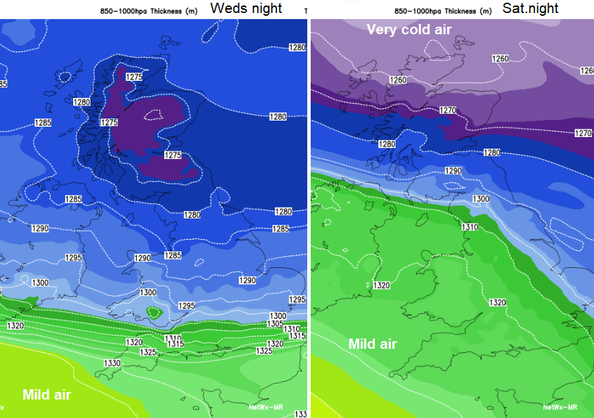
The cold Arctic air is key to all this. Remember the SSW, the Sudden Stratospheric Warming which was on major step on the path towards cold, snowy setups for northern Europe such as a “Beast from the East”. The Jetstream is much further south now and high pressure has formed at low latitudes but it is over Greenland, not Scandinavia. A Scandi High can drag bitterly cold air across continental Europe and throw heavy snow showers at the UK as very cold air moves over the North Sea. Any incoming low pressures from the Atlantic hit that very cold air and can give snow to the south or southwest. This week’s setup is bringing cold air down from the north, from the Arctic. Northern Norway saw -35C this week and the flow of snow showers has been mainly for northern Scotland, with a few clipping the Yorkshire coast and Northumberland. It's the same process: cold air over the UK, incoming frontal bands hitting that and snow appears.
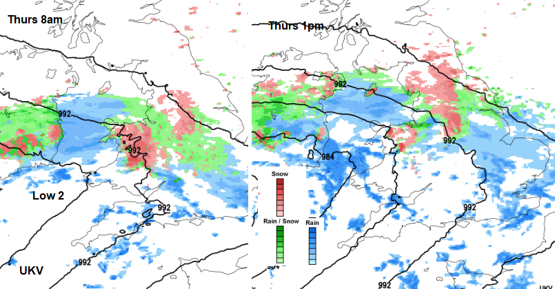
The original cold front waved about over southern England on Tuesday and as another system nudged in from the west, that front pushed up over Wales and southern England last night and gave the white covering for early Wednesday although there was rain in Cornwall with temperatures of +10C. Low 1 slides in from the west/southwest later on Wednesday with wintry precipitation. Then a more forceful low pressure bowls in on Thursday bringing rain, sleet and snow but also strong winds. So, conditions will deteriorate as low2 moves across the UK. It will be away by Friday.
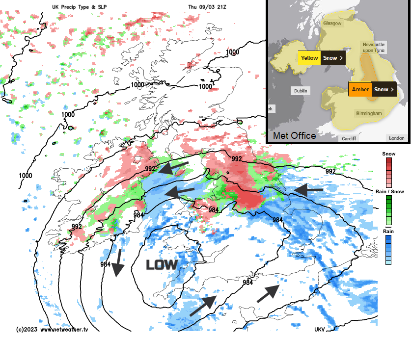
There has been a gap of fine but cold weather with sunshine between the snow showers of northern Scotland and the damp/wintry frontal band over southern Britain. Perhaps the odd slight flurry of snowflakes has passed by but overall, a portion of the UK has seen dry, chilly weather. The low pressure for Thursday is forecast to impact more of Britain and Northern Ireland and bring difficult conditions rather than just a slushy covering. An Amber warning has now been issued by the Met Office through the N.Midlands, Peak District, Yorkshire, the Pennines into NW England.
"Heavy snow is likely to cause significant disruption on Thursday afternoon and Friday morning. Snow is expected to develop over northern England on Thursday morning, becoming persistent through the afternoon and overnight into early Friday morning before slowly easing." MO
The area for the warning has already been adjusted and if you do have travel plans later this week do be aware that the zone across the country could shift again. The ECM model highlights Wales, northern England, the Midlands and Yorkshire/Lincolnshire but not really southern Scotland.
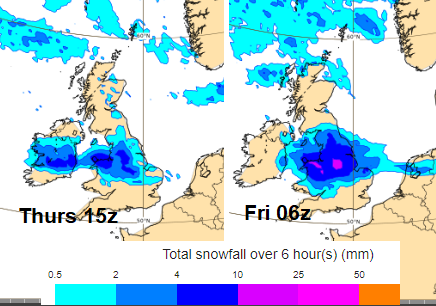
The low takes its time over the UK, still with the cold air to the north. This will lead to rain, sleet and snow for the Peak District, Sheffield and Leeds and there could be quite a covering. Updates will appear for this current yellow warning "10-15cm is expected quite widely above 100m, with a chance that 25-40cm could fall in some places."
Weekend
The battleground, between the milder air from the southwest and increasingly cold air in the far north, continues at the weekend. Confidence about where the frontal zones will be and how much precipitation they will deposit remains low but there will be more sleet and snow. Northern Britain looks most likely on Saturday night.