As we move into March, winter is making a reappearance. The forecast has cold Arctic air on a northerly flow with snow showers and the risk of ice. There will be sub-zero temperatures overnight, widespread frosts and the complication of frontal zones sliding in from the southwest, coming up against the cold air and potentially bringing some proper snow. All of that is set against the increasing daylight hours and a bit more strength in any sunshine.
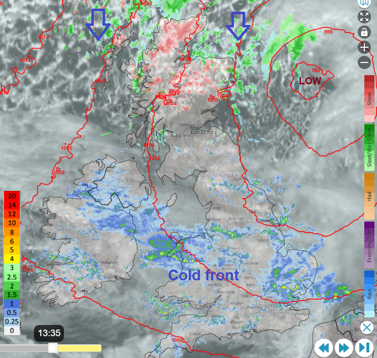
This week's charts will not be about definite times and precipitation certainty. Snow in the UK is usually quite tricky to forecast and although much of northern Scotland seeing snow showers is highly likely, other parts of the UK face a more fluid picture.
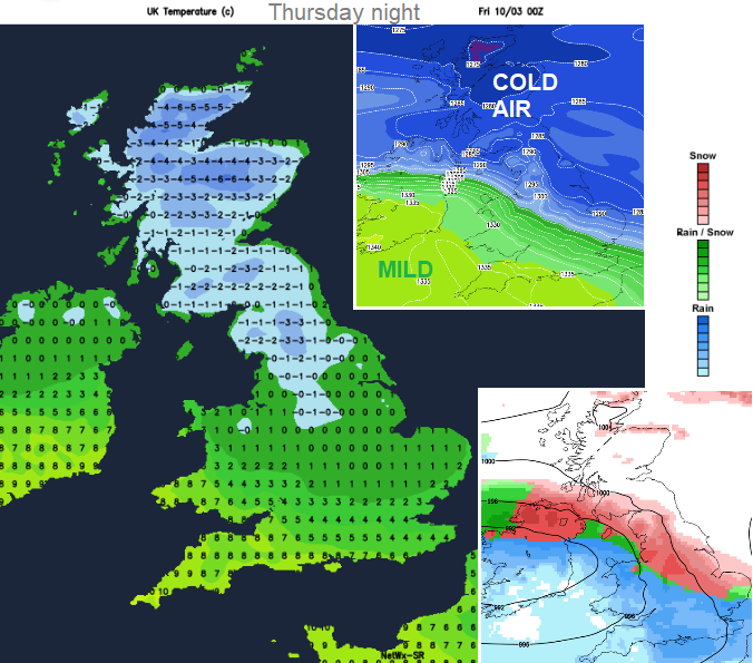
What will be catching the eye are charts like this. The cold Arctic air in place, and an incoming frontal system at night, where the rain is likely to turn to snow. Disruptive snow is being mentioned later in the week. Before that, even central or southern parts of the UK might awake to a covering of slushy snow. Might.
“Ice and some snow leading to difficult travel conditions in places.” Met Office
There are numerous snow and ice warnings from the UK Met Office: The next few days for northern and eastern Scotland and NE England, extending into eastern England and more of western Scotland. Overnight and for Tuesday morning, warnings for Northern Ireland and across parts of Wales & England. Wednesday sees a snow warning for south Wales and southern England. Thursday & Friday “Heavy snow has the potential to cause significant disruption on Thursday and Friday” for the Midlands northwards and Northern Ireland. Quite the collection.

Grampian and Highland Scotland are already seeing sleet and snow showers on a cold, damp feeling day. Inverness will see snow showers to start the week with temperatures of +1C but feeling more like -3C in the breeze. The low pressure in the North Sea is drawing down a rash of wintry showers for Monday and Tuesday but these do fade midweek. Early Wednesday will be particularly cold as could Friday morning and Saturday morning. There will be widespread frost, and the risk of ice. It will feel especially cold when the wind picks up.
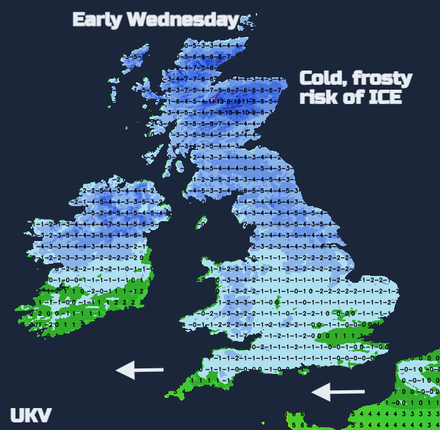
From Tuesday onwards any showers in the far north will be of snow or hail in the Arctic air but many places do become dry and even sunny around the middle of the week. It looks like bands of snow showers could feed in again from the north as the weekend starts.
What is much more complicated is further south and although driving up the A9 is never ideal, northern Scotland can cope with snow and ice in March. Further south, any bit of snow by 8am and the world is at an end, unless you are a (big) kid with a snow/strike day and a toboggan ready to go.
However, the Met Office warnings do include the possibility of proper UK snow and not just for Scotland.
“Snow could develop quite widely across the warning area on Thursday and Friday…Event totals could bring 5 to 10 cm of snow to many locations, even at low elevations…In addition, there is potential for strong winds, which may lead to blizzard conditions and drifting of lying snow.”
For Leeds, the cold front has moved through with Monday rain and the skies then brighten for Tuesday in the cold air with mid-week sunshine. Later in the week could see icy rain or snow. Belfast gets colder with sunshine for the next few days, frost overnight and a few snow showers from the north but mostly dry until Thursday.
The cold front reaches southern Britain tonight and almost stalls for early Tuesday. There are concerns that with the dig of cold air behind it there could be some snow along the back edge of the frontal band and also tricky conditions where it has rained, and not been enough time for gritting lorries to get out, or grit is washed away, and ice forms.
Linked to this cold front is a deepening low pressure which will impact Denmark tonight and on Tuesday. There are warnings from DMI for a snowstorm here with blizzard conditions and over 30cms of snow forecast. The cold air is plunging down through Scandinavia and the North Sea and the front takes its time to clear over the English Channel.
So, the Tuesday morning yellow warning is rather woolly but highlights an area that could see rain, sleet and hill snow overnight but also lead to slushy conditions for the morning rush hour or problematic ice. Icy rain could affect southern England during the day on Tuesday. Southampton will be cold and cloudy on Tuesday with the rain turning sleety. There could be some snow around early on Wednesday with a cold wind and then temperatures will leap up on Thursday.
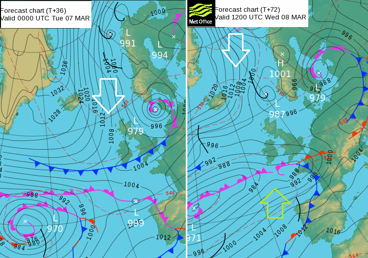
ECM model is keen on snow over SW Britain and southern counties of England for Tuesday night and Wednesday with “A period of snow is likely to cause some travel disruption “. The uncertainty is how the frontal boundary waves north. The UKV and GFS models have the precipitation skirting along the south coast, perhaps bringing a covering of snow to the South Downs and Dartmoor overnight then gathering itself later on Wednesday.
The ECM then has another pulse of snow across a thicker swathe of southern Britain during Wednesday evening and night. Other models keep a mix of rain, sleet, hill snow and the band just for southern counties. 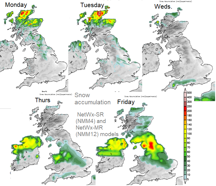
The frontal system for Thursday and Friday looks more forceful and pushes up from the southwest over N. Ireland and the Irish Sea. This could result in the highest totals for this week but the band may be further north or south, or that low might stay as a flatter wave. There could be mild air in the south by Friday, still the Arctic air over northern Scotland and a wintry mix with significant snowfall in-between.
Gfs 12z is getting might close to a call up from the banker... Deal or no deal......
14 minutes ago, cheshire snow said: So true I wait for our own @Day 10 superb analysis,there are a few knowledgeable posters in there but trying to find there posts in between all the rubbish is hard going. It's often mixed with the high chance...
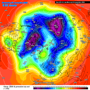
This might do,shame its late november not mid january
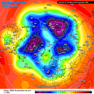
7 minutes ago, Mike Poole said: Models much better this afternoon, so far. I wonder if the morning runs were just suffering from a touch of noughtzeditus. Coldies live to fight another day. GFS now has this T240: Really need to the ECM to follow...
22 hours ago, andymusic said: Latest GFS 12Z RUN TODAY - flipping mega Scandanavian/Greenland blocking to the north of the UK, complete wind reversal, freezing cold temps and the potential for alot of snow, AN AMAZING BEAST FROM THE EAST, looks...
On 17/11/2026 at 15:14, SunnyG said: I take extreme mildness over the opposite. Looking at how heating bills are going to rise by a huge amount in the new year , A mild winter might not be a bad thing for the general public Cant see it being...