
Tropical Cyclone Freddy has moved right across the Southern Indian Ocean, over 5,000 thousand miles making landfall over Madagascar and forecast to hit Mozambique with devastating rains on Friday 24th
Cyclone Freddy struck Madagascar this week, its first landfall after a 17-day journey across the entire southern Indian Ocean. It brought heavy rain, wild winds, a storm surge to the east coast and large waves. It was named in the Australian area of responsibility but ended up in the southwest Indian Ocean after travelling more than 9,000km (5600 miles). It is rare for a cyclone to travel such a distance after forming so far east. Next will be landfall over Mozambique and further devastation.
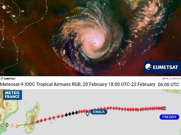
TC Freddy’s trek across Indian Ocean-Madagascar. Satellite: Meteosat-9 Product: GeoColor Timespan:13/02/2023 18:45 - 21/02/2023 20:45 UTC
Early warnings are hugely important for the island communities. The soil of Madagascar was already saturated inland from Cyclone Cheneso which stalled off the west coast with torrential rainfall in late January. 33 people were killed and 20 people are still missing with thousands still homeless before Cyclone Freddy turned up. Madagascar was hit by cyclones Batsirai and Emnati last year in February and although (at least) four people died in this event, Freddy was a smaller and faster moving cyclone and so didn’t bring as much rainfall or devastation as in 2022. It also missed La Reunion which Meteo France forecasts for, passing to the north.
Cyclone Freddy did weaken slightly before hitting Madagascar overnight Tues 21st to Weds 22nd February (from a Cat.4 to a Cat.3 storm). 7,000 people had been evacuated from coastal areas in a region that is prone to cyclones. However, as Freddy passes over the warm waters to the west of Madagascar it is intensifying once more before landfall on the coast of Mozambique, south of Beira.
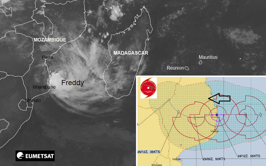
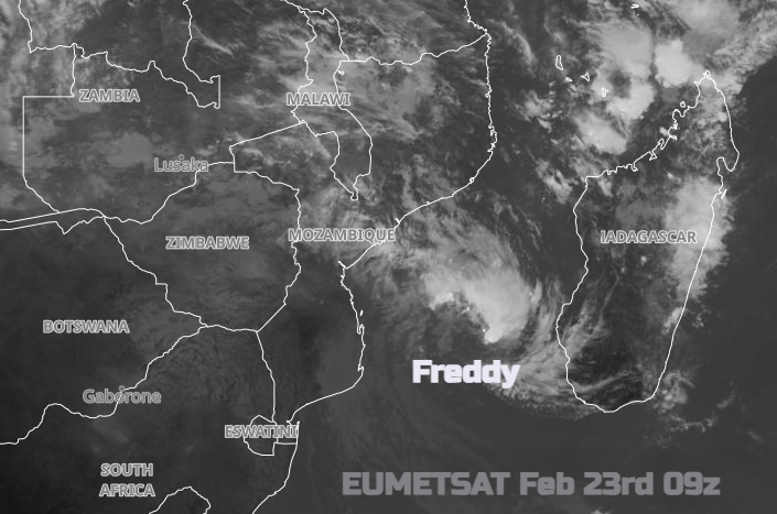
24/02/23 07Z EUMETSAT satellite and JTWC path
As Freddy continues westwards, strengthening over the Mozambique Channel and is forecast to make landfall over SE Africa on Friday 24th February. The area is already in a desperate situation with flooding in the rainy season, disease and damage. There is already a severe humanitarian situation in Mozambique before this Cyclone even arrives.
“There is a potential risk that months’ worth of rainfall may fall in the space of a few days, causing widespread flooding in an area which already has saturated soils and high river basin levels from unusually heavy seasonal rains.” WMO
There are also rainfall and flooding concerns for north-eastern South Africa, Zimbabwe, Eswatini and eastern Botswana for the end of the month.
It is its longevity and journey which made Cyclone Freddy stand out. It now holds the record for sustained strength over time in the Southern Hemisphere. It generated over 66 units of ACE, (Accumulated Cyclone Energy) which is a way of accounting for storm duration and intensity. This surpasses Cyclone Fantala in 2016 with records dating back to 1980.
There is an association between long-lived tropical cyclones in the South Indian Ocean and La Nina years (the cool phase of the El Nino Southern Oscillation cycle). TC Leon-Eline in 2000 was at the end of a very long La Nina and 2023 is also another La Nina year, like last year. Eline/Leon moved from near Indonesia right across to Madagascar, then Mozambique to Nambia.
As Tropical Cyclone Freddy made landfall and moved across the island of Madagascar it began to fall apart but recovered over open water, before its next landfall in the early hours of Friday 24th.
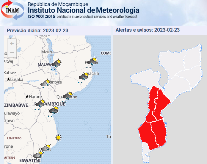
On 21 February, Mozambique and its national meteorological service INAM declared a red alert in order to accelerate response operations. This region sees too many devastating cyclones, such as TC Ida in March 2019
There will be strong, impactful winds and large waves with coastal flooding but it is the rainfall which brings the most threat. There will be flash flooding, river floods, landslides and damage. If Freddy’s progress slows, that will result in higher rainfall totals.
As Madagascar reopens its airports and schools and inspects damage to houses, people can leave the various shelters to seek food and aid. Mozambique and other parts of southern Africa await more heavy rain and more flooding.
The rainy season has run from October last year and impacted thousands of families across Mozambique. There have already been heavy rains in some provinces, over 200mm in 24 hours, with extensive flooding. Some of this is from neighbouring countries upstream but the ground is already saturated before Cyclone Freddy even arrives
“According to preliminary estimations, some 400,000 people are living in the areas of Freddy’s projected trajectory.” UN Office for the Coordination of Humanitarian Affairs
INGD (National Institute for Disaster Risk Management and Reduction) estimates that flooding in central and southern Mozambique – including following Cyclone Freddy’s landfall – might affect up to 1.75 million people.
Already there has been widespread flooding with houses damaged or destroyed. There is damage to power supplies, roads, health centres and schools with farmland also being impacted just in the rainy season. Flooding increases the risk of cholera, an ongoing lethal issue in Mozambique, along with conflict in parts of the country. It’s not just another cyclone, is another extreme event adding to an existing severe situation.
TC Freddy had a notable effect on the (sea) wave field in the southern Indian Ocean. Significant wave height (SWH) is measured by Sentinel altimeters, devices that measure altitude, the distance of a point above sea level. In order to improve future forecasts a lot of data is gathered and the forecasts are reviewed. Hindcasts are also run, so looking backwards rather than just ‘fore’cast models. Copernicus (EU’s Earth Observation Programme) has a Marine Service which uses altimetry data, such as from Freddy, along with information from multiple other sources. This showed that “the effect of the cyclone on the sea surface was relatively localised, but resulted in SWH of over 7m near the storm centre.” These waves were driven westward onto the coast of Madagascar. This research will help forecasts in the future and the modelling and then feeds into the early warning systems.


