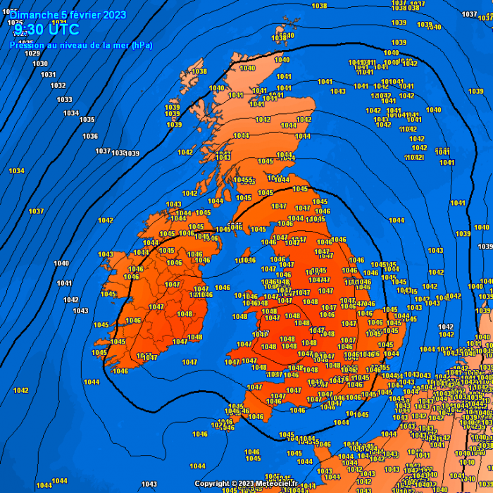
A look at weather extremes in February: today has seen atmospheric pressure reach 1048mb in Wales, likely breaking local records, but the blog will also look at the extremes of cold and warm in the last month of meteorological winter.
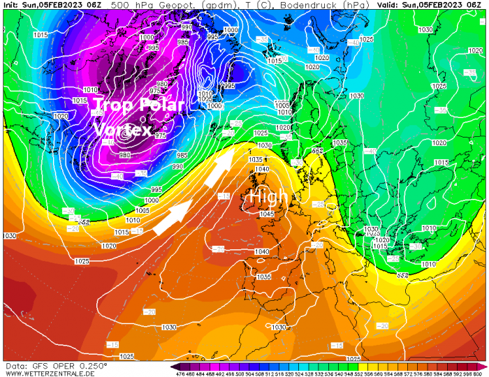
This blog will look at past weather extremes for February in the UK and to start, although not record-breaking, today atmospheric pressure across the UK is very high, 1048 hPa readings across Wales this morning in the centre of an anticyclone. Highest pressure for February in the UK, appears to be 1052.9 hPa recorded at Aberdeen on 1st Feb 1902. Probably be some individual weather station records being broken today, particularly Wales and parts of the southwest.The intense anticyclone is very likely linked to the intense tropospheric Polar Vortex that has brought very cold air to NE USA / eastern Canada and is now moving out over the far NW Atlantic - causing strong WAA aloft downstream.
The last month of meteorological winter can bring an early taste of spring or remind it is still truly a winter month with sub-zero temperatures and snow. The weather can be benign with high pressure in control, such as we are seeing at the moment and during the coming week or stormy, such as we saw in 2022 with Storm Dudley and Eunice.
The old saying ‘As the days grow longer the cold grows stronger’ may not hold sway every February, February 2022 was mild, as was 2020 and particularly 2019 – which was the mildest since 2002. But 2018, particularly late February and early March that year, made this cold saying ring true.
January is, on average, the coldest month of the year over a greater part of the British Isles, though February is not far behind and is on average colder than December. However, February, on average, is fractionally colder than January in some western and southwestern districts where maritime influences are dominant, which includes Devon, Cornwall, west Wales, Isle of Man and some of the Scottish Islands. This is because the North Atlantic is at its coldest in late February and early March.
Some of our coldest Februarys in living memory have featured easterly winds though, as deep cold has built up over the large landmass of Russia through the winter. February 1986 was the coldest in my lifetime, the second coldest February of the 20th century (after 1947) and the coldest month since January 1963, with a Central England Temperature (CET) of -1.1C. Like 1947, the weather patterns were completely blocked by high pressure over NW Russia bringing very cold air from the east, with easterly winds on 23 days of the month and the other days calm. There wasn’t really any widespread disruptive snow that month, snow was mostly light and generally in the east, the consistently low maxima were the most remarkable thing about the month, the temperature didn’t rise above 1C all month at Buxton in Derbyshire, while the highest value all month at Hampstead in North London was just 2.9C.
Another notable February cold spell since then occured in 1991, although only during the first half of that month, the second half was mild. A ten-day cold spell started on the 5th of that month, as northeast winds brought in very cold air from northern Russia leading to widespread snowfall, particularly in the east. Snowfall depths across NE England exceeded 30cm in places, with 50cm in Bradford. Even London saw 20cm of snow. With temperatures not rising above freezing for 5 days and maxima as low as -6C widespread, snow was of the dry and powdery variety, which lead to the infamous ‘wrong type of snow’ excuse for breakdowns and delays to trains from British Rail which was at the time the state-run railways.
Februarys since then haven’t really got as cold, probably because the months since then have seen a decline in the frequency of spells of cold easterly winds while seeing an increase in westerly or southwesterly winds. There were a few cold Februarys that stand out 1996, 2009 and 2010. But since then, 2018 only really stands out as being notably cold as in a departure of more than a few degrees from average, and that month it was only towards the end when it got really cold when the Beast from the East arrived tiggered by a Sudden Stratospheric Warming earlier in the month.
At the other end of the temperature scale for February’s past, we only have to go back to 2019 for the first time 20C has been breached. On 25th 20.6C was recorded in Trawsgoedd, north Wales, then on 26th Kew Gardens in west London reached 21.2C. This is exceptional warmth for February and one of the increasingly frequent warming signs that our climate is changing.
Looking ahead for this February, it’s looking like a rather dry first half for much of the UK, away from the far northwest, thanks to high pressure in charge. Signs from model ensemble means for a change by mid-month, with EPS and GEFS 500mb mean showing an upper trough close to the UK, meaning a cyclonic flow with low pressure in charge bringing unsettled and windy conditions. Depending on where the trough sets up, it may be mild or chilly, trough to the west = mild, trough over the UK = chilly.
.png?w=700)
Around mid-month too, 15-20th, GFS and it ensembles along with ECWMF extended ensembles have been increasing the probability of a Sudden Stratospheric Warming (SSW) around this time. This reversal of winds from westerly to easterly as the polar vortex is weakened and displaced from the pole could propagate towards the troposphere (where our weather happens) and trigger high latitude blocking which could bring cold and wintry weather to the UK at the end of the month and into early March. But no guarantee this may happen, even of there is a SSW.
Loading recent activity...