Every month of 2022, so far, has seen above average temperatures, this autumn has been notably warm on the back of an exceptionally hot summer. The period between mid-October to mid-November has been notably warm, the UK November mean temperature is currently 2.6C above the average. With 5 days left of the month, November will likely make the 11th month in a row with UK mean temperature above the 1991-2020 average.
After the anomalous warmth through much of the autumn right through to the middle of this month, temperatures have been a little closer to average over the last few days, though will turn a little milder over the weekend and into early next week.
However, there looks set to be a significant pattern change as we go into December. Weather models for a while now have indicated changes in the upper flow patterns which will lead to high pressure to the northeast to extend west, halting and pushing away the relentless unsettled conditions off the Atlantic and, instead, ushering in colder and drier conditions.
Watch upper level high pressure extend west over NE Europe - which will eventually push away the Atlantic low pressure systems and feed in colder air from the east

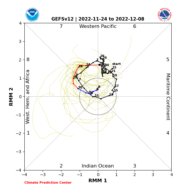
The changes are coming about from changes in the upper flow patterns upstream over the Pacific and North America. These changes are likely linked to a wave of enhanced tropical convection known as the Madden Julian Oscillation (MJO) moving into the tropical western Pacific. The energy released by this convection tends to be transported poleward and can cause changes in the jet stream causing it to buckle, with a more wavy configuration working downstream across North America, the North Atlantic and Europe. A bit like waving a rope up and down, it causes waves to work down it.
MJO currently moving through phase 7 (red line with dates)
Typical 500mb pattern +/- 10 day lag response in December following MJO moving through phase 7
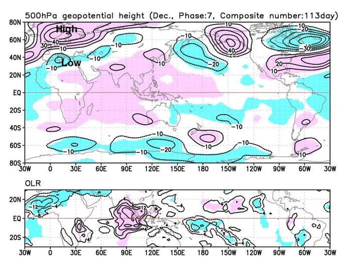
The changes to the upper patterns upstream over North America will manifest in an upper trough replacing the ridging over central and western USA / Canada. This will in turn pull the tropospheric polar vortex, that’s been over Greenland and far NW Atlantic driving our recent unsettled weather, further west across Canada. This will then allow a large area of high pressure that’s recently been building over the Urals and western Russia to extend westwards across Scandinavia and far NE Atlantic / Norwegian Sea.
So we’ll see an end to the prolonged often unsettled and mild spell of weather that’s dominated much of autumn, to be replaced by increasingly drier and colder conditions, as high pressure builds to the northeast to allow a colder continental flow from the east or southeast by the end of next week.
Watch mild conditions replaced by colder air spreading west from Russia through next week, as the high extends west over NE Europe / far NE Atlantic
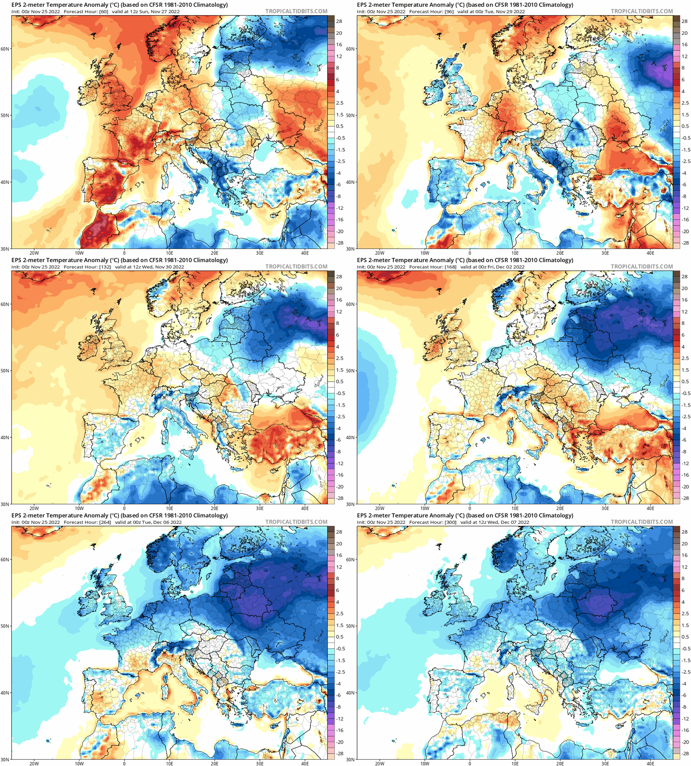
For now, the continental flow does not look to have enough depth of cold to bring any snow, so there is not Beast from the East showing at the moment, despite what some media maybe hyping. Compare what's typically currently modelled when the easterly sets in and what the 2018 Beast from the East brought from the east and you'd agree:
But, if the blocking to the northeast and perhaps north (if it continues to retrograde) holds long enough, we could eventually see deeper cold move in from the east or northeast in early December – which may generate snow showers off the North Sea or snow where Atlantic fronts try to move in from the west. But for now, expect some colder and drier conditions to develop later next week and weekend, with an increasing risk of widespread frost overnight under clear skies.
Next 7 days look very chilly on EC 18Z. Plenty of frosts ...
38 minutes ago, johncam said: GFS flipped again . Looked a lot more changeable and milder. Probably won't be the last time it will flip!
Personally it's too soon for significant cold , still think mid December , blocking to the North. Seeing plenty signs of PV instability, weakness. And those zonal wind forecasts are sugar candy as they hint at reversals early January. It's just a...
7 hours ago, Retron said: I took a particular interest in snowy winters as a kid in the 80s, and indeed once I became sentient every single winter had snow... until 87/8, that is, which is when I realised my gran wasn't going mad and indeed some...
GFS flipped again . Looked a lot more changeable and milder.
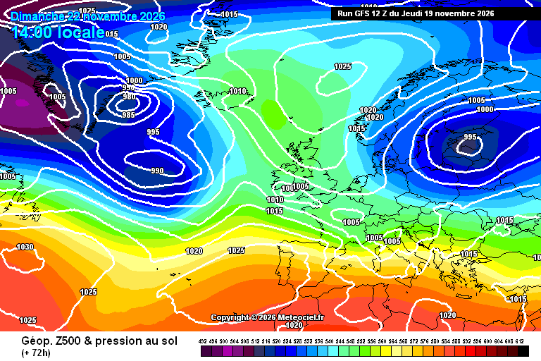
1 hour ago, SqueakheartLW said: Are we seeing the first signs of the winter pattern showing themselves. I've seen a lot of interesting charts just on the recent GFS run with blocking highs to our north or east and lows sliding underneath or...