Lively weather for midweek with line convection, lightning, heavy rain and gusty winds. Many low pressures are coming our way with gales tonight for western Scotland as the rain reaches SE England.
Atlantic low pressures will dominate our UK weather this week. During Wednesday, one low is moving past NW Scotland with active weather fronts, gales, thundery downpours and heavy rain. The trailing front from this midweek low will pester SE Britain into Thursday.
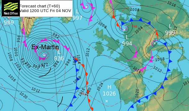
A smaller low pressure swings in from the northwest later on Thursday brushing western areas in a cooler flow. Next, the North Atlantic will be dominated by ex-hurricane Martin. This large deep low pressure will edge towards Iceland and throw its weather fronts over Ireland and western Britain by Saturday. This will bring blustery rain and a push of milder air from the southwest.
Another low pressure will sprint across the Atlantic at the weekend, to the south of ex-Martin and reach the UK later on Sunday with strong winds and showery rain for exposed areas. Mild air then follows for a potentially windy Monday.
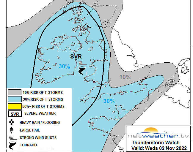
The setup very mobile and changeable. Some parts of the UK have now seen some decent rain and the ground is already wet. Leaf fall might cause drainage issues where there is further heavy rainfall. There is plenty of instability around midweek and a thunderstorm watch which includes the risk of severe weather and gusts over 65mph.
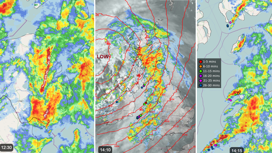
" squally linear convection along the rear of the rain band. Stronger convection may produce thunder and lightning… there is potential for one or two tornadoes where broken line segments develop rotation. Also, hail may accompany convection along with intense rain leading to localised flooding.
More details in the Convective forecast 2nd/3rd November.
During Wednesday lunchtime there was Line Convection moving NE over Northern Ireland. This meant a sudden spell of torrential rain, gusty winds and poor visibility. These squally bands continue to swing around the low pressure in the northwest with more wet and windy weather through the afternoon, extending over western & northern Britain.
New lines are developing over the Irish Sea with severe gales and these bands will bring difficult conditions on the roads for the evening rush hour.
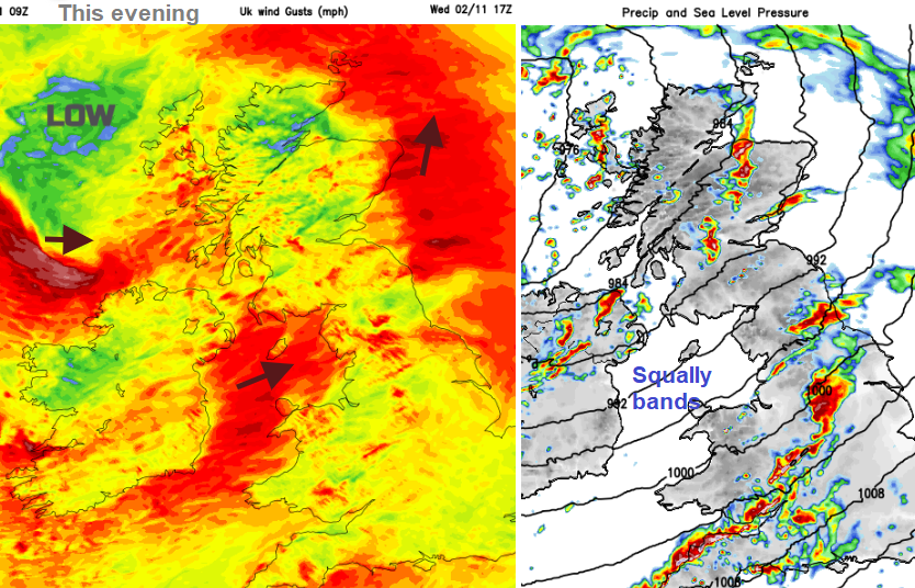
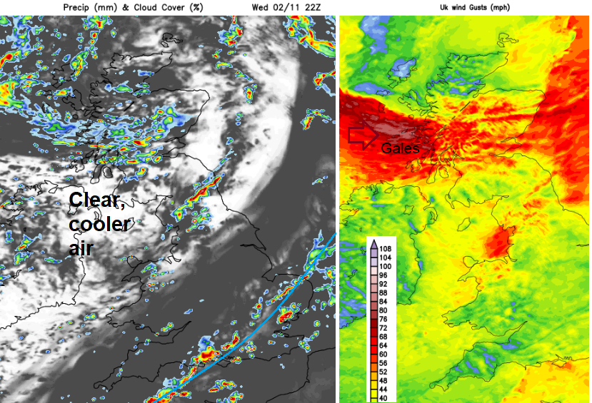
There are a few weather warnings from the Met Office, including a wind warning for western Scotland, the Western Isles and Orkney. The UKV model is still showing a vicious tuck of westerly gales around the low centre this evening. This is forecast to affect Argyll, the Inner Hebrides, Highland region including Skye and then reaching across to the Moray Firth, Inverness, Grampian and reaching the Western Isles in the small hours. Exposed areas could see Severe gales and gusts of 70 to 80mph tonight. Before dawn the strongest winds will be over the north of mainland Scotland and reaching Orkney.
Inshore waters Western Scotland (Mull of Kintyre to Ardnamurchan Point) "Wind - South veering west, 7 to severe gale 9, backing south or southwest 3 to 5 later. Sea state- Rough or very rough becoming moderate or rough later."
The cold front will continue to give showery rain over SE Britain during Wednesday night and then as the front begins to wave, even more rain pulses over SE England. There is a yellow rain warning for the area but with some uncertainty about where will see the highest totals. More of Greater London, even Suffolk could see heavy rain for a time on Thursday.
“20-30 mm of rain is expected fairly widely, with 40 mm in a few places near English Channel coasts. The ground is fairly wet, and recent fallen leaves may reduce drainage of surface water”
Thursday sees the winds almost drop out, light for most of the UK except the tip of Cornwall as that little low drops by. This low pressure will introduce more heavy showers to the Irish Sea and SW Britain later in the day. These showers will again include thunderstorms, hail and gusty winds.