Potentially lively autumn weather this week with heavy rain and strong winds. A midweek low pressure is being watched which could bring severe gales and cause disruption as the western rain continues.
We are into October now and it will feel even more like autumn this week with rain at times. There are brisk winds, even gales in the forecast. There will always be more rain for western areas, with several heavy bouts for western Scotland. A midweek deepening low pressure is being watched as that could bring severe gales and heavy, persistent rain but there is uncertainty about which areas will see the most impacts. Southeastern Britain misses much of the rain this week and there will be mild air allowing temperatures to stay in the mid to high teens.
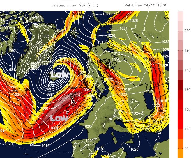
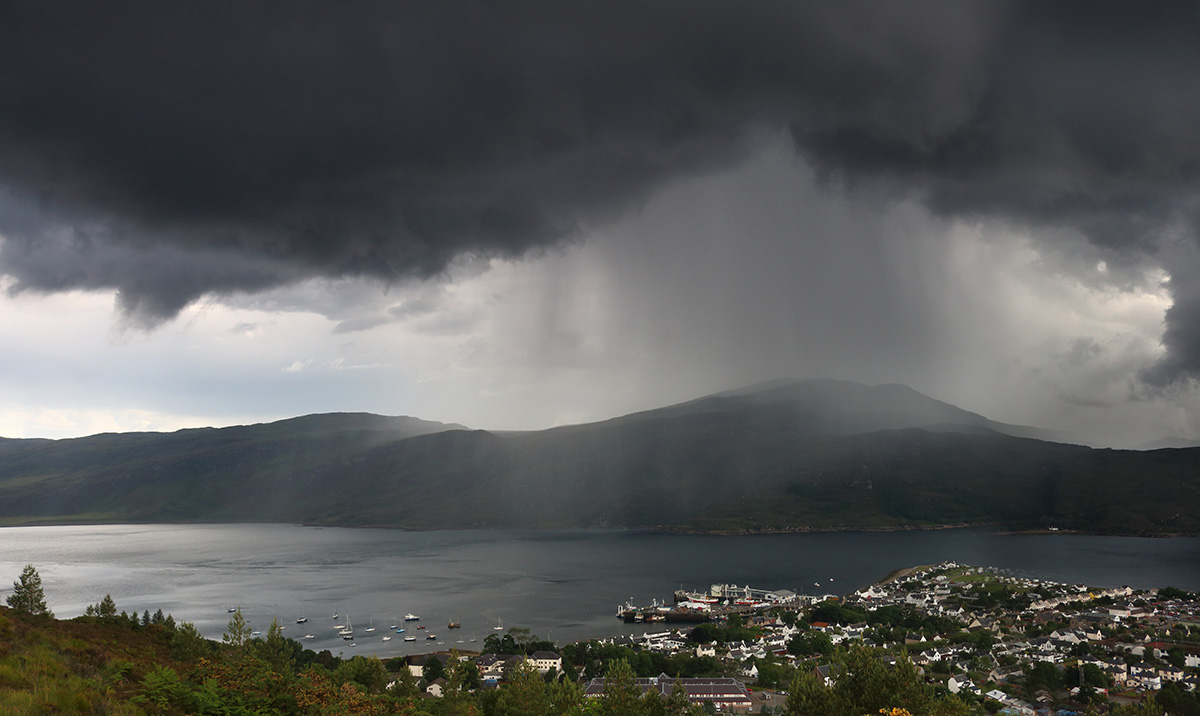
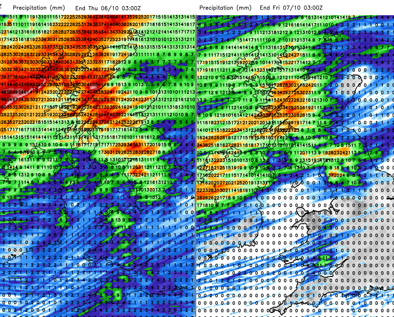
The Jetstream is ploughing straight across the northern Atlantic towards the UK. We are still seeing tropical cyclone developments in the Atlantic and eastern Pacific thanks to warm air and waters. The seasonal shift in the far north to colder air has begun which leads to contrasting air masses to feed the jet. The stronger jetstream develops various low pressures this week which then scoot past or over the UK. Trailing weather fronts will bring more cloud and further frontal rain and the UK Met Office had just issued a yellow rain warning for western Scotland. This highlights the risk of travel disruption on Tuesday morning as there have been problems with landslides and heavy rain damage to sections of railway tracks recently
“Widely 30 to 50 mm of rainfall is likely with perhaps 80 mm over some of the mountains.” MO
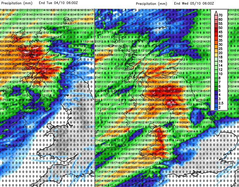 Heavy rain in the northwest but drier in the south and east
Waving frontal bands can edge further north or south which then affects the timing of rain and areas affected. Monday’s rain brushes the north coast of Northern Ireland and will mainly NW Scotland including the Islands. However, the same frontal band keeps feeding in from the Atlantic and edges down the west coast. This then brings the risk of disruption by early Tuesday to western Scotland as the heavier rain spreads to Glasgow and SW Scotland then NW England and Wales. Wales looks wet through Tuesday afternoon as skies brighten to the north of the front but stay cloudy to the south. Outbreaks of rain just continue to snake in from the west, through the Irish Sea and over Central Britain before the main development of the week takes place.
There is still uncertainty about how a low centre could develop and where will see the strongest winds, gales even severe gales through Tuesday night into Wednesday. There will be more heavy rain wrapped around the low centre. Heavy showers then follow in from the northwest. The UK is left in a blustery cooler flow with bands of heavy showers whistling in from the west. There will be hail and thunder for NW Britain on Thursday and then the heavier bands manage to swing across more of the UK on Friday.
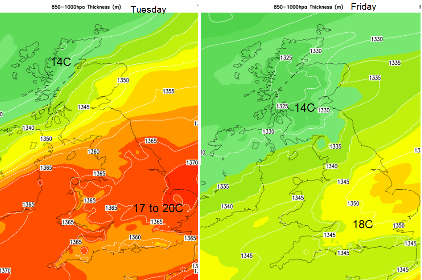
At times cool air tucks in from the northwest. Wednesday night will be nippy in the north early on and cool for SE Britain by dawn on Thursday. Early Saturday also looks cool but by day this week temperatures will be in the mid to high teens and south-eastern Britain continues to miss a lot of the rain.
The Met Office has also issued a rather wide wind warning for Tuesday night and Wednesday. It is over Scotland, Northern Ireland and much of Wales and northern England. This accommodates for the uncertainty in the forecast whilst still giving a heads up of the potential for severe weather.
“There is a chance of a deep low pressure system bringing gusts of 70 to 80 mph to northern parts of the UK on Wednesday. Should this develop disruption would be expected?” MO
For northern and western parts of the UK, it will be wet and feel cold with winds ranging from strong to gale force. Exposed areas could see severe gales, even storm force winds are being mentioned, but it will need another day for the details to firm up. The latest UKV model shows a tight curl of wild winds over the Scottish Islands on Wednesday morning with gusts in the southwestern quadrant over 80mph as the low centre moves by.
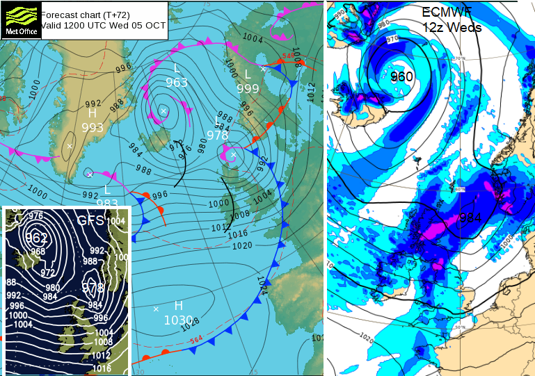 Three model outputs for 12Z Wednesday
The ECM model and Netwx MR model show a broader swathe of strong winds over Wales and England on Wednesday morning. With the low deepening more over the North Sea on its way to Norway later on Wednesday. There is low confidence for now around this middle of the week wet and windy weather, something to watch.
More discussion on the Netweather community forum. Storm names for the 2022/23 season