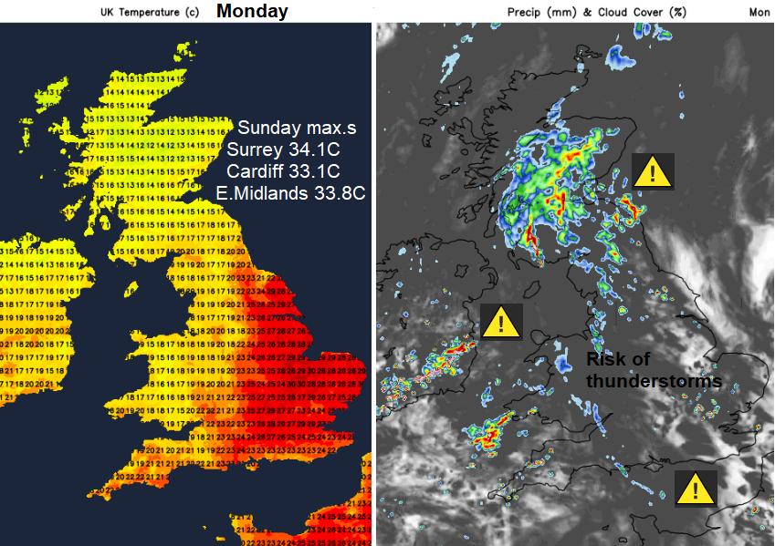
A change in our UK weather after the heat. Temperatures are coming down although another very warm day for parts of England. Flooding concerns from sudden downpours and thunderstorms.
The extreme heat event is now over but it will be another very warm day for central and eastern England with temperatures in the mid to high 20s Celsius and some places reaching 30C on Monday. For those finding the heat too much, things are turning cooler and fresher everywhere this week.
There is also rain in the forecast but it still could miss some areas and it’s not going to solve the drought conditions.
It will feel cooler and fresher for many, with more cloud and rain. Scotland and Northern Ireland have already seen rain to end the weekend with some torrential downpours and thunderstorms moving through. The main concern from any heavy rainfall is surface runoff issues, thanks to the hard, dry ground. The Vue cinema in Inverness saw water pouring in on Sunday evening as the roof of a nearby Tesco store collapsed under a slow-moving storm. There have been some stunning photos of lightning and Arcus clouds
Today, northern areas will see areas of rain, thunderstorms and the risk of disruption. There are several warnings from the Met Office, one continuing for Northern Ireland and Scotland from Sunday.
From today’s Netweather Convective forecast, Nick Finnis explains about the early elevated thunderstorms in the west and over Scotland.
“This corridor with pulses of elevated storms and showers moving NE will likely continue through much of the day across S and E. Scotland while edging slowly further east from the Irish Sea across NW England, Wales and SW England – but storm activity probably waning in southern extent.”
For England and Wales, “Hit-and-miss thunderstorms likely to develop through Monday, producing some torrential downpours for some spots, and possible disruption…slow-moving torrential downpours could produce 20-30 mm inside an hour, with 40-50 mm falling in around 2-3 hours in a few spots” Met Office
Although there is a widespread Met Office warning area, within that there will be a scattering of these storms. There are concerns about flash flooding but also the risk of hail and frequent lightning.
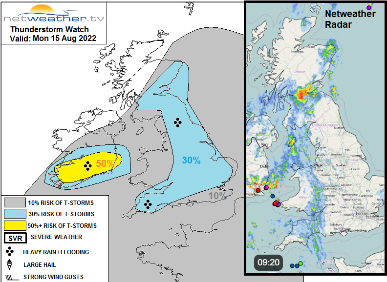
The highlighted area over southern Ireland is where a strong breeze convergence zone looks to develop, and lift along that convergence will likely support slow-moving thunderstorms.
Keep an eye on the Netweather Radar today to see developments and movement of the heavy showers and storms.
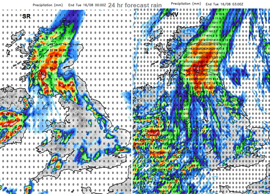
The forecast rain charts for 24 hrs on Monday show a distribution of the rain and heavy showers. (offset by 3 hrs, more showers for SW England overnight). This gives an idea of where might see the heaviest rain, or be more prone to downpours today and this evening. The overall drift is north/north-eastwards.
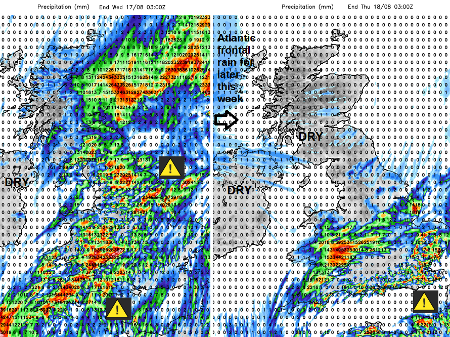
As the week progresses the chance of a shower, heavy downpour even thunderstorm increases over Wales and England, tipping towards the south/southeast of England by midweek. There are ongoing yellow warnings.
It’s another occasion when the output from a weather app could be quite frustrating. It might show rain symbols all day, which is actually the threat of heavy downpours in the area. Your location could miss them or get drenched and someone 2 miles down the road sees the opposite.
Over the next few days, it becomes drier for Northern Ireland and Scotland and cooler in a north wind. It’s back to school this week for some Scottish schools so the change in the weather could be seen as well timed. Usually, in September it seems like a fortnight of fine weather turns up as other UK school head back.
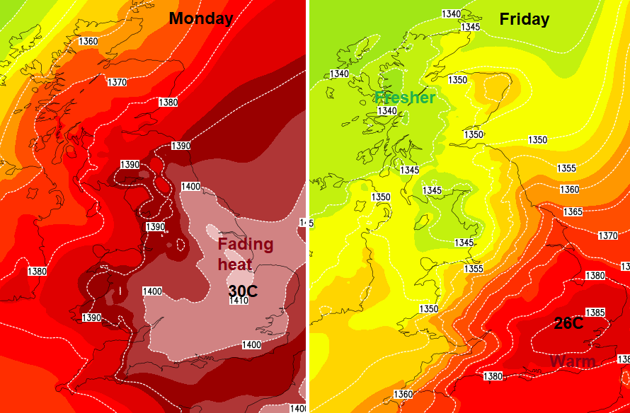
Temperatures that have been up into the mid-30s Celsius will drop to the mid 20sC. There will still be strong sunshine in the gaps in-between showers, brightness and fine weather at times. The air quality forecast is still for moderate pollution today with an alert yesterday for Ozone levels as parts of Britain moved into the high category. That should come down as we slowly move back to weather coming in from the Atlantic to end this week.