Thursday sees the start of the Commonwealth Games. A good deal of fair weather for the next few days in Birmingham. Looking warmer across the UK on Friday but weekend pulses of rain from the west
This evening sees the Opening Ceremony for the Commonwealth Games in Birmingham which will run until Monday 8th August. After the Queens Baton Relay, the athletes are waiting to start their competitions with many festival sites around the West Midlands holding public events and outdoor activities.
“A celebration of creativity across the West Midlands” Birmingham 2022
High pressure is slinking off over the North Sea today. There has been some significant rain (even thundery in the Irish Sea) from a feature marked as a trough in the southerly flow over northern England and the Isle of Man already this morning. The rain is extending into southern Scotland and Co. Down and becomes more showery through the day but still with some heavy downpours. Wales will see a few showers inland but it looks like the weather will be dry but rather cloudy for the West Midlands this afternoon and evening. With very light winds it will feel quite warm in Birmingham this evening at 20C
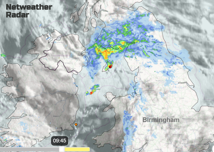
Many parts of the UK will have a fair day with a good deal of cloud about, some bright spells and light winds. Temperatures this afternoon from 15 to 23C with a light easterly breeze for North Sea coasts. The scattered heavy showers will linger into the night, focused over southern Scotland and the far north of England.
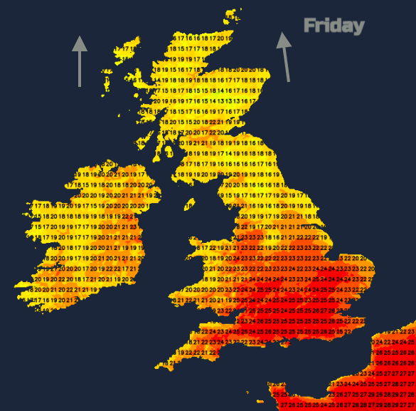
Friday looks much warmer for southern Britain with temperatures rising into the mid to high 20sC. Elsewhere it will feel warmer in the high teens and low twenties Celsius with a light southerly breeze. Again, there could be a scattering of showers up the spine of northern Britain by Friday lunchtime but fine and bright for most of the UK. The forecast for the next few days for Birmingham is for a lot of fine, bright weather. Temperatures staying in the low to mid-twenties Celsius with occasional spells of rain as Atlantic fronts wave in. The timings on these will vary.
One low pressure will be moving in later on Friday bringing more cloud from the west and eventually frontal rain to Northern Ireland and western Scotland.
The rain turns showery as it spread over more of northern Britain on Saturday morning. Much of Scotland brightens up but the cloud and patchy rain will wave over Northern Ireland and NW England by day. There is some uncertainty around the position of these bands so remember the overall picture rather than concentrating on Weather App for dry and wet timings
Another band of showery rain looks to move in further south on Sunday almost along the Bristol Channel across to The Thames, dry and brighter to the north. Then another band for Monday.
It’s quite a frustrating forecast to get the detail of the rain right. Many parts will see lengthy spells of fair weather, mostly dry, not hot but bright and warm with light winds. The weekend brings these spells of showery rain snaking eastwards but often missing large chunks of the UK.
Saturday looks very warm again for the SE half of Britain, well up into the 20sC and some warmth for eastern Scotland as the wind veers to a westerly. By Sunday there will be a dig of cooler air on a north-westerly wind which lasts into Monday.